Login
Register


HRJ
Harnett Regional Jetport Airport
Official FAA Data Effective 2024-04-18 0901Z
Chart Supplement

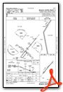
VFR Chart of KHRJ
Sectional Charts at SkyVector.com
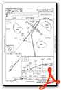
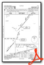
IFR Chart of KHRJ
Enroute Charts at SkyVector.com
Location Information for KHRJ
Coordinates: N35°22.81' / W78°43.93'Located 04 miles NW of Erwin, North Carolina on 152 acres of land. View all Airports in North Carolina.
Surveyed Elevation is 201 feet MSL.
Operations Data
|
|
Airport Communications
| AWOS-3: | 119.025 Tel. 910-814-3946 |
|---|---|
| FAYETTEVILLE APPROACH: | 125.175 285.575 |
| FAYETTEVILLE DEPARTURE: | 125.175 285.575 |
| UNICOM: | 122.700 |
| CLASS C: | 125.175 |
| CTAF: | 122.700 |
| ATIS at FBG (17.9 SW): | 139.25 |
| D-ATIS at POB (18.7 SW): | 132.3 |
| AWOS-3 at JNX (19.1 NE): | 120.225 919-934-3851 |
Nearby Navigation Aids
|
| ||||||||||||||||||||||||||||||||||||||||||||||||||||||||||||


Runway 05/23
| Dimensions: | 5005 x 75 feet / 1526 x 23 meters | |
|---|---|---|
| Surface: | Asphalt in Excellent Condition | |
| Weight Limits: | S-45, D-60 | |
| Edge Lighting: | Medium Intensity | |
| Runway 05 | Runway 23 | |
| Coordinates: | N35°22.49' / W78°44.26' | N35°23.13' / W78°43.61' |
| Elevation: | 187.9 | 201.7 |
| Runway Heading: | 40° True | 220° True |
| Markings: | Non-Precision Instrument in good condition. | Non-Precision Instrument in good condition. |
| Glide Slope Indicator | P2L (3.00° Glide Path Angle) | P2L (3.00° Glide Path Angle) |
| REIL: | Yes | Yes |
| Obstacles: | 96 ft Trees 2593 ft from runway, 172 ft right of center | |
Services Available
| Fuel: | 100LL (blue), Jet A-1+ |
|---|---|
| Transient Storage: | Hangars,Tiedowns |
| Airframe Repair: | MAJOR |
| Engine Repair: | MAJOR |
| Bottled Oxygen: | HIGH/LOW |
| Bulk Oxygen: | NONE |
| Other Services: | AIR AMBULANCE SERVICES,PILOT INSTRUCTION,AIRCRAFT RENTAL |
Ownership Information
| Ownership: | Publicly owned | |
|---|---|---|
| Owner: | HARNETT COUNTY | |
| 200 ALEXANDER DRIVE, 108 E. FRONT STREET | ||
| LILLINGTON, NC 27546 | ||
| 910-814-2740 | COLEY PRICE, ASST COUNTY MGR. | |
| Manager: | GREG FRANK | |
| 615 AIRPORT RD | ||
| ERWIN, NC 28339 | ||
| 910-814-2740 | ||
Operational Statistics
| Single Engine Aircraft Based on Field: | 32 | Statistics collected for 12 month period ending 2022-08-12 | |
|---|---|---|---|
| Multi-Engine Aircraft Based on Field: | 3 | Annual Commercial Operations: | none |
| Jet Aircraft Based on Field: | 1 | Annual Commuter Operations: | none |
| Helicopters Based on Field: | 1 | Annual Air Taxi Operations: | 300 |
| Military Aircraft Based on Field: | none | Annual Military Operations: | 7000 |
| Gliders Based on Field: | none | Annual GA Local Operations: | 30000 |
| Ultralights Based on Field: | 1 | Annual GA Itinerant Operations: | 14000 |
Other Remarks
- RWY 05, 60 FT DROP-OFF 350 FT FM THR & RWY 23, 25 FT DROP-OFF 70 FT LEFT OF CNTRLN.
- FOR CD CTC FAYETTEVILLE APCH AT 910-484-8012.
- SVC AVBL 24/7 WITH PRIOR ARNGMNTS. GPU AND BULK OIL AVBL.
- ARPT LOCATED 18 NM NE OF POPE ARMY AIRFIELD, LOW LEVEL MIL ACT INVOF ARPT.
- ROTG BCN OBSC BY TREES N & W OF ARPT.
- 0LL 100LL 24 HR. SELF SVC WITH CREDIT CARD.
- ACTVT REIL RWY 05 & RWY 23; MIRL RWY 05/23 - CTAF; PAPI RWY 05 & RWY 23 ON CONSLY.
Weather Minimums

Instrument Approach Procedure (IAP) Charts
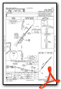
Nearby Airports with Instrument Procedures
| ID | Name | Heading / Distance | ||
|---|---|---|---|---|
 |
KPOB | Pope AAF Airport | 227° | 18.7 |
|
KJNX | Johnston Regional Airport | 060° | 19.3 |
|
KTTA | Raleigh Exec Jetport At Sanford-Lee County Airport | 303° | 21.8 |
|
KFAY | Fayetteville Regional/Grannis Field Airport | 197° | 24.4 |
|
KRDU | Raleigh-Durham International Airport | 354° | 29.9 |
|
KCTZ | Clinton-Sampson County Airport | 143° | 30.2 |
|
5W4 | P K Airpark Airport | 226° | 31.2 |
|
KSOP | Moore County Airport | 255° | 33.4 |
|
W40 | Mount Olive Municipal Airport | 105° | 35.4 |
|
KGWW | Wayne Exec Jetport Airport | 082° | 37.9 |
|
KGSB | Seymour Johnson AFB Airport | 093° | 37.9 |
|
KSCR | Siler City Municipal Airport | 297° | 42.5 |
Airport Images
Do you have a recent image of this airport? Upload it here!


