Login
Register


HRO
Boone County Airport
Official FAA Data Effective 2024-04-18 0901Z
Chart Supplement

VFR Chart of KHRO
Sectional Charts at SkyVector.com
IFR Chart of KHRO
Enroute Charts at SkyVector.com
Location Information for KHRO
Coordinates: N36°15.69' / W93°9.28'Located 03 miles NW of Harrison, Arkansas on 425 acres of land. View all Airports in Arkansas.
Surveyed Elevation is 1364 feet MSL.
Operations Data
|
|
Airport Communications
| ASOS: | 121.125 Tel. 870-365-8550 |
|---|---|
| CTAF: | 123.000 |
| UNICOM: | 123.000 |
| AWOS-3 at BBG (16.4 N): | 124.625 417-334-0218 |
| ATIS at BBG (16.4 N): | 124.625 |
| AWOS-3PT at FLP (27.6 E): | 132.075 870-453-2380 |
- APCH/DEP SVC PRVDD BY MEMPHIS ARTCC ON FREQS 126.85/281.55 (HARRISON RCAG).
Nearby Navigation Aids
|
| ||||||||||||||||||||||||||||||||||||||||||||||||||||||


Runway 18/36
| Dimensions: | 6161 x 150 feet / 1878 x 46 meters | |
|---|---|---|
| Surface: | Asphalt / Grooved in Good Condition | |
| Weight Limits: | S-38, D-53, ST-84 | |
| Edge Lighting: | High Intensity | |
| Runway 18 | Runway 36 | |
| Coordinates: | N36°16.20' / W93°9.22' | N36°15.19' / W93°9.34' |
| Elevation: | 1362.9 | 1351.3 |
| Traffic Pattern: | Left | Left |
| Runway Heading: | 186° True | 6° True |
| Markings: | Precision Instrument in good condition. | Precision Instrument in good condition. |
| Glide Slope Indicator | V4L (3.00° Glide Path Angle) | V4L (3.00° Glide Path Angle) |
| Approach Lights: | MALSR 1,400 Foot Medium-intensity Approach Lighting System with runway alignment indicator lights. | |
| REIL: | Yes | |
Services Available
| Fuel: | 100LL (blue), Jet-A |
|---|---|
| Transient Storage: | Hangars,Tiedowns |
| Airframe Repair: | MINOR |
| Engine Repair: | MINOR |
| Bottled Oxygen: | NONE |
| Bulk Oxygen: | NONE |
| Other Services: | AIR FREIGHT SERVICES,AIR AMBULANCE SERVICES,CHARTER SERVICE,PILOT INSTRUCTION,AIRCRAFT RENTAL |
Ownership Information
| Ownership: | Publicly owned | |
|---|---|---|
| Owner: | BOONE COUNTY | |
| 100 N MAIN SUITE 300 | ||
| HARRISON, AR 72601 | ||
| 870-741-5760 | ||
| Manager: | JUDY MC CUTCHEON | |
| PO BOX 1114 | ||
| HARRISON, AR 72601 | ||
| 870-741-6954 | ||
Operational Statistics
| Single Engine Aircraft Based on Field: | 31 | Statistics collected for 12 month period ending 2021-12-31 | |
|---|---|---|---|
| Multi-Engine Aircraft Based on Field: | 10 | Annual Commercial Operations: | 2100 |
| Jet Aircraft Based on Field: | 2 | Annual Commuter Operations: | none |
| Helicopters Based on Field: | none | Annual Air Taxi Operations: | 1150 |
| Military Aircraft Based on Field: | none | Annual Military Operations: | 100 |
| Gliders Based on Field: | none | Annual GA Local Operations: | 3400 |
| Ultralights Based on Field: | none | Annual GA Itinerant Operations: | 4000 |
Other Remarks
- THIS AIRPORT HAS BEEN SURVEYED BY THE NATIONAL GEODETIC SURVEY.
- DEER & BIRDS ON & INVOF ARPT.
- FOR CD CTC MEMPHIS ARTCC AT 901-368-8453/8449.
- 0LL 100LL AVBL 24 HRS SELF SERVE.
- ACTVT MALSR RWY 36, REIL RWY 18 & HIRL RWY 18/36 - CTAF.
Weather Minimums

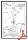
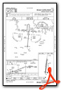
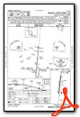
Instrument Approach Procedure (IAP) Charts
Nearby Airports with Instrument Procedures
| ID | Name | Heading / Distance | ||
|---|---|---|---|---|
 |
KBBG | Branson Airport | 352° | 16.4 |
|
KPLK | M Graham Clark Downtown Airport | 350° | 22.1 |
|
4M1 | Carroll County Airport | 287° | 23.9 |
|
KFLP | Marion County Regional Airport | 086° | 27.4 |
|
KFWB | Branson West Municipal - Emerson Field Airport | 335° | 28.8 |
|
H34 | Huntsville Municipal Airport | 249° | 31.1 |
|
4A5 | Searcy County Airport | 131° | 32.6 |
|
KBPK | Baxter County Airport | 078° | 33.8 |
|
94K | Cassville Municipal Airport | 306° | 44.5 |
|
KROG | Rogers Exec - Carter Field Airport | 278° | 46.6 |
|
KASG | Springdale Municipal Airport | 264° | 47.1 |
|
KAOV | Ava Bill Martin Memorial Airport | 028° | 48.3 |
Airport Images
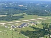
By: val.foreit


