Login
Register


HSA
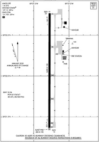
Stennis International Airport
Official FAA Data Effective 2024-04-18 0901Z
Chart Supplement

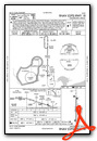
KHSA Airport Diagram
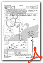
VFR Chart of KHSA
Sectional Charts at SkyVector.com
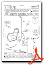
IFR Chart of KHSA
Enroute Charts at SkyVector.com
Location Information for KHSA
Coordinates: N30°22.07' / W89°27.28'Located 08 miles NW of Bay St Louis, Mississippi on 591 acres of land. View all Airports in Mississippi.
Surveyed Elevation is 22 feet MSL.
Operations Data
|
|
Airport Communications
| AWOS-3PT: | 118.375 Tel. 228-466-9320 |
|---|---|
| STENNIS TOWER: | 127.15 229.4 |
| STENNIS GROUND: | 121.725 229.4 |
| GULFPORT APPROACH: | 124.6 ;130-309 127.5 ;310-129 254.25 ;310-129 354.1 ;130-309 |
| GULFPORT DEPARTURE: | 124.6 ;130-309 127.5 ;310-129 254.25 ;310-129 354.1 ;130-309 |
| UNICOM: | 122.950 |
| CTAF: | 127.150 |
| AWOS-3PT at MJD (12.5 NW): | 119.075 601-798-4136 |
| ASOS at ASD (19.1 W): | 132.475 985-643-7263 |
| ASOS at GPT (19.5 E): | 119.45 228-867-9937 |
- APCH/DEP SVC PRVDD BY HOUSTON ARTCC (ZHU) ON FREQS 132.6/316.075 (MOBILE RCAG) WHEN GULFPORT APCH CTL (GPT) CLSD.
Nearby Navigation Aids
|
| ||||||||||||||||||||||||||||||||||||||||||||||||||||||||||||


Runway 18/36
| Dimensions: | 8498 x 150 feet / 2590 x 46 meters | |
|---|---|---|
| Surface: | Asphalt / Grooved in Good Condition | |
| Weight Limits: | 62 /F/B/X/T, ST-472, DT-955 | |
| Edge Lighting: | High Intensity | |
| Runway 18 | Runway 36 | |
| Coordinates: | N30°22.77' / W89°27.27' | N30°21.37' / W89°27.28' |
| Elevation: | 22.5 | 12.7 |
| Traffic Pattern: | Left | Left |
| Runway Heading: | 180° True | 0 |
| Declared Distances: | TORA:8498 TODA:8498 ASDA:8498 LDA:8498 | TORA:8498 TODA:8498 ASDA:8498 LDA:8498 |
| Markings: | Precision Instrument in poor condition. | Non-Precision Instrument in poor condition. |
| Glide Slope Indicator | P4L (3.00° Glide Path Angle) | P4L (3.00° Glide Path Angle) |
| Approach Lights: | MALSR 1,400 Foot Medium-intensity Approach Lighting System with runway alignment indicator lights. | |
| REIL: | Yes | |
| Obstacles: | 40 ft Tree 2100 ft from runway, 200 ft left of center | 55 ft Trees 2100 ft from runway |
Services Available
| Fuel: | 100LL (blue), Jet A+ |
|---|---|
| Transient Storage: | Hangars,Tiedowns |
| Airframe Repair: | MAJOR FOR ALL RPRS CALL 228-463-2389. |
| Engine Repair: | MAJOR |
| Bottled Oxygen: | NOT AVAILABLE |
| Bulk Oxygen: | NOT AVAILABLE |
| Other Services: | PILOT INSTRUCTION,AIRCRAFT RENTAL,AIRCRAFT SALES |
Ownership Information
| Ownership: | Publicly owned | |
|---|---|---|
| Owner: | HANCOCK CO PORT & HARBOR CMSN | |
| 14054 FRED & AL KEY RD | ||
| KILN, MS 39556 | ||
| 228-467-7070 | ||
| Manager: | JERRY ISLAND | |
| 7250 STENNIS AIRPORT RD | ||
| KILN, MS 39556 | ||
| 228-467-7070 | ||
Operational Statistics
| Single Engine Aircraft Based on Field: | 28 | Statistics collected for 12 month period ending 2023-04-30 | |
|---|---|---|---|
| Multi-Engine Aircraft Based on Field: | 4 | Annual Commercial Operations: | 10 |
| Jet Aircraft Based on Field: | 1 | Annual Commuter Operations: | none |
| Helicopters Based on Field: | none | Annual Air Taxi Operations: | 769 |
| Military Aircraft Based on Field: | none | Annual Military Operations: | 24515 |
| Gliders Based on Field: | none | Annual GA Local Operations: | 6354 |
| Ultralights Based on Field: | none | Annual GA Itinerant Operations: | 7886 |
Other Remarks
- WHEN ATCT CLSD, FOR CD CTC HOUSTON ARTCC AT 281-230-5622.
- AVOID OVERFLYING SCHOOLS .4 NM E OF RWY 18/36 WHEN POSS.
- FBO ATNDD MON-FRI 0700-2000, SAT-SUN 0800-1800.
- AFT HRS CALLOUT - 228-463-2389.
- NMRS LOW FLYING FISH SPOTTER ACFT OPS NEAR SHORELINE BTN GULFPORT & BAY ST. LOUIS.
- BIRDS ON & INVOF ARPT.
- 0LL FOR FUEL & FBO SVCS AFT HRS CALL 228-463-2389.
- ACTVT MALSR RWY 18; REIL RWY 36; PAPI RWY 18 & 36; HIRL RWY 18/36 - CTAF.
Weather Minimums
Instrument Approach Procedure (IAP) Charts
Nearby Airports with Instrument Procedures
| ID | Name | Heading / Distance | ||
|---|---|---|---|---|
 |
KMJD | Picayune Municipal Airport | 305° | 12.5 |
|
KASD | Slidell Airport | 266° | 19.1 |
|
KGPT | Gulfport-Biloxi International Airport | 083° | 20.1 |
|
M13 | Poplarville/Pearl River County Airport | 354° | 25.2 |
|
KBIX | Keesler AFB Airport | 084° | 27.6 |
|
M24 | Dean Griffin Memorial Airport | 028° | 32.2 |
|
KBXA | George R Carr Memorial Air Field Airport | 321° | 34.1 |
|
KNEW | Lakefront Airport | 236° | 35.6 |
|
KNBG | New Orleans NAS Jrb (Alvin Callender Field) Airport | 222° | 44.0 |
|
KMSY | Louis Armstrong New Orleans International Airport | 242° | 47.5 |
|
KPQL | Trent Lott International Airport | 083° | 48.3 |
|
KHDC | Hammond Northshore Regional Airport | 280° | 50.8 |
Airport Images
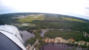
By: jtrolinger

By: jtrolinger


