Login
Register


HWV
Brookhaven Airport
Official FAA Data Effective 2024-04-18 0901Z
Chart Supplement

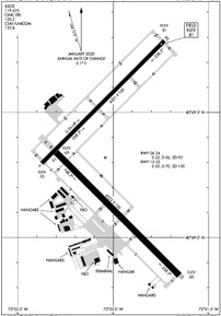
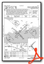
KHWV Airport Diagram
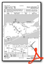
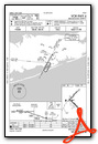
VFR Chart of KHWV
Sectional Charts at SkyVector.com
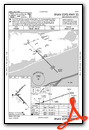
IFR Chart of KHWV
Enroute Charts at SkyVector.com
Location Information for KHWV
Coordinates: N40°49.32' / W72°52.01'Located 01 miles N of Shirley, New York on 630 acres of land. View all Airports in New York.
Surveyed Elevation is 81 feet MSL.
Operations Data
|
|
Airport Communications
| ASOS: | 119.625 Tel. 631-399-7095 |
|---|---|
| NEW YORK APPROACH: | 120.05 343.75 |
| NEW YORK DEPARTURE: | 120.05 343.75 |
| CLEARANCE DELIVERY: | 133.2 |
| UNICOM: | 122.800 |
| CTAF: | 122.800 |
| ATIS at ISP (10.7 W): | 120.725 |
| ASOS at ISP (10.8 W): | 120.725 631-471-0131 |
| ASOS at FOK (11.4 E): | 119.925 631-288-0588 |
Nearby Navigation Aids
|
| ||||||||||||||||||||||||||||||||||||||||||||||||||||||||||||


Runway 15/33
| Dimensions: | 4222 x 150 feet / 1287 x 46 meters | |
|---|---|---|
| Surface: | Asphalt-Concrete in Good Condition | |
| Weight Limits: | S-52, D-70, ST-120 | |
| Edge Lighting: | Medium Intensity | |
| Runway 15 | Runway 33 | |
| Coordinates: | N40°49.34' / W72°52.30' | N40°48.85' / W72°51.65' |
| Elevation: | 69.4 | 60.3 |
| Traffic Pattern: | Left | Left |
| Runway Heading: | 135° True | 315° True |
| Markings: | Basic in good condition. | Basic in good condition. |
| Glide Slope Indicator | P2L (3.00° Glide Path Angle) | P2L (3.00° Glide Path Angle) |
| REIL: | Yes | Yes |
| Obstacles: | 55 ft Trees 1375 ft from runway, 359 ft right of center | 59 ft Trees 987 ft from runway, 367 ft left of center |
Runway 06/24
| Dimensions: | 4201 x 100 feet / 1280 x 30 meters | |
|---|---|---|
| Surface: | Asphalt in Good Condition | |
| Weight Limits: | S-32, D-56, ST-93 | |
| Edge Lighting: | Medium Intensity | |
| Runway 06 | Runway 24 | |
| Coordinates: | N40°49.30' / W72°52.38' | N40°49.79' / W72°51.73' |
| Elevation: | 70.0 | 81.2 |
| Traffic Pattern: | Left | Left |
| Runway Heading: | 45° True | 225° True |
| Markings: | Precision Instrument in good condition. | Basic in good condition. |
| Glide Slope Indicator | V4L (3.00° Glide Path Angle) RWY 06 VGSI & GLIDEPATH NOT COINCIDENT. | |
| Approach Lights: | MALSR 1,400 Foot Medium-intensity Approach Lighting System with runway alignment indicator lights. | |
| REIL: | Yes | |
| Obstacles: | 77 ft Trees 1879 ft from runway, 611 ft right of center | 46 ft Trees 288 ft from runway, 328 ft right of center |
Services Available
| Fuel: | 100LL (blue), Jet-A |
|---|---|
| Transient Storage: | Hangars,Tiedowns |
| Airframe Repair: | MAJOR |
| Engine Repair: | MAJOR |
| Bottled Oxygen: | NONE |
| Bulk Oxygen: | NONE |
| Other Services: | CHARTER SERVICE,GLIDER SERVICE,PILOT INSTRUCTION,AIRCRAFT RENTAL,AIRCRAFT SALES,GLIDER TOWING SERVICES |
Ownership Information
| Ownership: | Publicly owned | |
|---|---|---|
| Owner: | TOWN OF BROOKHAVEN | |
| 135 DAWN DRIVE | ||
| SHIRLEY, NY 11967 | ||
| 631-451-5300 | ||
| Manager: | DAVID MORAN | |
| 135 DAWN DRIVE | ||
| SHIRLEY, NY 11967 | ||
| 631-451-6299 | ALTN PHONE 631-451-6291 OR 631-451-6299. | |
Operational Statistics
| Single Engine Aircraft Based on Field: | 165 | Statistics collected for 12 month period ending 2017-12-31 | |
|---|---|---|---|
| Multi-Engine Aircraft Based on Field: | 6 | Annual Commercial Operations: | none |
| Jet Aircraft Based on Field: | none | Annual Commuter Operations: | none |
| Helicopters Based on Field: | 1 | Annual Air Taxi Operations: | none |
| Military Aircraft Based on Field: | none | Annual Military Operations: | 66 |
| Gliders Based on Field: | 5 | Annual GA Local Operations: | 41779 |
| Ultralights Based on Field: | none | Annual GA Itinerant Operations: | 12539 |
Other Remarks
- GLIDER OPNS DALGT HOURS.
- OVERNIGHT RAMP PARKING $5.00.
- EXTENSIVE PARACHUTE JUMPING ACTIVITY INVOF ARPT.
- ALL TWY LIGHTS OPR.
- FOR CD CTC NEW YORK APCH AT 516-683-2449 OR 133.2
- TGL ON HOL, WKENDS & NON-DALGT HRS NOT RCMDD.
- RELOCATED THRESHOLD IS TAXIWAY Z1
- DINER/LUNCHEONETTE OPN 7 DAYS/WEEK 0700-1600.
- GLIDERS USE RIGHT TRAFFIC PATTERN FOR RYS 24 & 33; GLIDERS USE LEFT TRAFFIC PATTERN FOR RYS 06 & 15
- UPPER AIR OBSERVATION BALLOONS LAUNCHED 3 MI NORTH OF ARPT 0600 & 1800.
- PILOTS BE AWARE WHEN CONDUCTING PRACTICE ILS APCHS: EXTENSIVE LIGHT ACFT TRAINING ON & INVOF ARPT ALL HRS.
- DEER ALL AREAS OF ARPT ESPECIALLY AT NIGHT.
- ACTVT MALSR RWY 06; REIL RWYS 24, 15, & 33; PAPI RWYS 15 & 33; MIRL RWYS 06/24 & 15/33 - CTAF.
Weather Minimums
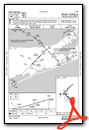
Instrument Approach Procedure (IAP) Charts
Nearby Airports with Instrument Procedures
| ID | Name | Heading / Distance | ||
|---|---|---|---|---|
 |
KISP | Long Island Mac Arthur Airport | 261° | 10.8 |
|
KFOK | Francis S Gabreski Airport | 083° | 10.8 |
 |
87N | Southampton Heliport | 085° | 18.3 |
|
KBDR | Bridgeport/Sikorsky Airport | 330° | 23.6 |
|
KFRG | Republic Airport | 257° | 25.5 |
|
KHVN | Tweed/New Haven Airport | 357° | 26.5 |
|
KJPX | East Hampton Town Airport | 073° | 29.2 |
|
KSNC | Chester Airport | 025° | 37.5 |
|
KHPN | Westchester County Airport | 291° | 40.9 |
|
KOXC | Waterbury-Oxford Airport | 342° | 41.2 |
|
KMMK | Meriden Markham Municipal Airport | 002° | 41.2 |
|
KJFK | John F Kennedy International Airport | 255° | 43.0 |
Airport Images

By: roadapple


