Login
Register


HZY
Northeast Ohio Regional Airport
Official FAA Data Effective 2024-04-18 0901Z
Chart Supplement

VFR Chart of KHZY
Sectional Charts at SkyVector.com
IFR Chart of KHZY
Enroute Charts at SkyVector.com
Location Information for KHZY
Coordinates: N41°46.67' / W80°41.81'Located 08 miles SE of Ashtabula, Ohio on 737 acres of land. View all Airports in Ohio.
Surveyed Elevation is 926 feet MSL.
Operations Data
|
|
Airport Communications
| ASOS: | 118.325 Tel. 440-576-0219 |
|---|---|
| BUFFALO APPROACH: | 121.0 |
| BUFFALO DEPARTURE: | 121.0 |
| CTAF: | 122.800 |
| UNICOM: | 122.800 |
| ASOS at GKJ (23.4 SE): | 121.425 814-337-2590 |
| ASOS at ERI (29.3 NE): | 120.35 814-835-7112 |
| ATIS at ERI (29.7 NE): | 120.35 |
- APCH/DEP SVC PRVDD BY BUFFALO APCH (BUF) ON 121.0 0600-0000 OR CALL 716-626-6920. APCH/DEP SVC PRVDD BY CLEVELAND ARTCC (ZOB) ON FREQS 127.075/292.175 (WATERFORD RCAG) 0000-0600.
Nearby Navigation Aids
|
| ||||||||||||||||||||||||||||||||||||||||||||||||||||||||||||


Runway 09/27
| Dimensions: | 5900 x 100 feet / 1798 x 30 meters | |
|---|---|---|
| Surface: | Asphalt / Grooved in Good Condition | |
| Weight Limits: | 42 /F/C/X/T, S-70, D-100, ST-150 | |
| Edge Lighting: | High Intensity | |
| Runway 09 | Runway 27 | |
| Coordinates: | N41°46.57' / W80°42.44' | N41°46.76' / W80°41.17' |
| Elevation: | 906.8 | 926.0 |
| Traffic Pattern: | Left | Left |
| Runway Heading: | 79° True | 259° True |
| Displaced Threshold: | 400 Feet | |
| Declared Distances: | TORA:5900 TODA:5900 ASDA:5100 LDA:5100 | TORA:5900 TODA:5900 ASDA:5500 LDA:5100 |
| Markings: | Non-Precision Instrument in fair condition. | Non-Precision Instrument in fair condition. |
| Glide Slope Indicator | P4L (3.00° Glide Path Angle) | P4L (3.00° Glide Path Angle) |
| REIL: | Yes | Yes |
Services Available
| Fuel: | 100LL (blue), Jet A+ |
|---|---|
| Transient Storage: | Hangars,Tiedowns PISTON ACFT MUST TIEDOWN USING APN ANCHOR POINTS WHEN UNATNDD - CALL FOR DTLS. |
| Airframe Repair: | NONE |
| Engine Repair: | NONE |
| Bottled Oxygen: | NONE |
| Bulk Oxygen: | NONE |
| Other Services: | PILOT INSTRUCTION,AIRCRAFT RENTAL |
Ownership Information
| Ownership: | Publicly owned | |
|---|---|---|
| Owner: | ASHTABULA CO ARPT AUTH | |
| PO BOX 379 | ||
| JEFFERSON, OH 44047-0379 | ||
| 440-576-9271 | ||
| Manager: | LANCE BUSHWEILER | |
| PO BOX 379 | ARPT PHYS ADS: 2382 AIRPORT RD, JEFFERSON, OH 44047-9491. | |
| JEFFERSON, OH 44047-0379 | ||
| 440-576-9271 | ||
Operational Statistics
| Single Engine Aircraft Based on Field: | 21 | Statistics collected for 12 month period ending 2021-10-12 | |
|---|---|---|---|
| Multi-Engine Aircraft Based on Field: | 1 | Annual Commercial Operations: | none |
| Jet Aircraft Based on Field: | 2 | Annual Commuter Operations: | none |
| Helicopters Based on Field: | none | Annual Air Taxi Operations: | 145 |
| Military Aircraft Based on Field: | none | Annual Military Operations: | 2 |
| Gliders Based on Field: | none | Annual GA Local Operations: | 528 |
| Ultralights Based on Field: | none | Annual GA Itinerant Operations: | 520 |
Other Remarks
- THIS AIRPORT HAS BEEN SURVEYED BY THE NATIONAL GEODETIC SURVEY.
- SNOW REMOVAL OPS DRG ATNDD HRS, MAY BE LTD HOLS & WKENDS.
- SER: ACFT DEICE - TYPE 1 & 4 FLUID, LAV CART, & GPU AVBL.
- FOR CD CTC BUFFALO APCH AT 716-626-6920, WHEN APCH CLSD CTC CLEVELAND ARTCC AT 440-774-0232.
- FLD CONDS UNMON AFT BUS HRS.
- DEER & BIRDS INVOF ARPT.
- FEE FOR SER AFT HRS & WKENDS CALL AHD 440-855-1126.
- RAMP FEE FOR TURBINE ACFT.
- 0LL 100LL AVBL H24 SELF SVC VIA CREDIT CARD.
- ACTVT REIL RWY 09 & 27; HIRL RWY 09/27 - 123.3. PAPI RWY 09 & 27 OPR CONSLY.
Weather Minimums

Instrument Approach Procedure (IAP) Charts
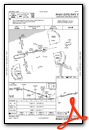
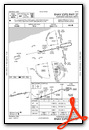
Nearby Airports with Instrument Procedures
| ID | Name | Heading / Distance | ||
|---|---|---|---|---|
 |
KGKJ | Port Meadville Airport | 112° | 23.5 |
|
4G1 | Greenville Municipal Airport | 145° | 24.1 |
|
7G8 | Geauga County Airport | 220° | 25.7 |
|
KERI | Erie International/Tom Ridge Field Airport | 051° | 29.7 |
|
KYNG | Youngstown/Warren Regional Airport | 178° | 31.0 |
|
KLNN | Lake County Exec Airport | 259° | 31.6 |
|
KCGF | Cuyahoga County Airport | 250° | 37.8 |
|
KPOV | Portage County Airport | 216° | 42.2 |
|
6G1 | Titusville Airport | 102° | 44.1 |
|
KFKL | Venango Regional Airport | 122° | 44.7 |
|
29D | Grove City Airport | 147° | 44.8 |
|
KBKL | Burke Lakefront Airport | 250° | 47.0 |


