Login
Register


I22
Randolph County Airport
Official FAA Data Effective 2024-04-18 0901Z
Chart Supplement

VFR Chart of I22
Sectional Charts at SkyVector.com
IFR Chart of I22
Enroute Charts at SkyVector.com
Location Information for I22
Coordinates: N40°10.06' / W84°55.76'Located 03 miles E of Winchester, Indiana on 70 acres of land. View all Airports in Indiana.
Surveyed Elevation is 1122 feet MSL.
Operations Data
|
|
Airport Communications
| COLUMBUS APPROACH: | 134.45 352.05 |
|---|---|
| COLUMBUS DEPARTURE: | 134.45 352.05 |
| IC: | 352.05 |
| UNICOM: | 123.000 |
| CTAF: | 123.000 |
| AWOS-3 at PLD (17.3 N): | 124.675 260-726-7882 |
| AWOS-3T at VES (18.3 E): | 125.9 937-526-3154 |
| ATIS at MIE (21.9 W): | 133.25 |
Nearby Navigation Aids
|
| ||||||||||||||||||||||||||||||||||||||||||||||||||||||||||||


Runway 08/26
| Dimensions: | 4300 x 75 feet / 1311 x 23 meters | |
|---|---|---|
| Surface: | Asphalt / Grooved in Excellent Condition | |
| Weight Limits: | 21 /F/A/X/T, S-64, D-90, ST-176 | |
| Edge Lighting: | Medium Intensity | |
| Runway 08 | Runway 26 | |
| Coordinates: | N40°9.98' / W84°56.21' | N40°10.14' / W84°55.31' |
| Elevation: | 1115.9 | 1122.8 |
| Traffic Pattern: | Left | Left |
| Runway Heading: | 77° True | 257° True |
| Markings: | Non-Precision Instrument in good condition. | Non-Precision Instrument in good condition. |
| Glide Slope Indicator | P2L (3.00° Glide Path Angle) | P2L (3.00° Glide Path Angle) |
| REIL: | Yes | Yes |
| Obstacles: | 17 ft Crops 780 ft from runway, 210 ft right of center | 13 ft Road 650 ft from runway |
Services Available
| Fuel: | 100LL (blue), Jet-A |
|---|---|
| Transient Storage: | Hangars,Tiedowns |
| Airframe Repair: | MINOR |
| Engine Repair: | MINOR |
| Bottled Oxygen: | NONE |
| Bulk Oxygen: | NONE |
| Other Services: | PILOT INSTRUCTION,AIRCRAFT RENTAL |
Ownership Information
| Ownership: | Publicly owned | |
|---|---|---|
| Owner: | RANDOLPH CO BOAC | |
| 2937 E STATE RD32 | ||
| WINCHESTER, IN 47394 | ||
| 765-584-3611 | ||
| Manager: | ERIC LIVINGSTON | |
| 2937 E STATE RD 32 | ||
| WINCHESTER, IN 47394 | ||
| 765-584-3611 | ||
Operational Statistics
| Single Engine Aircraft Based on Field: | 11 | Statistics collected for 12 month period ending 2019-12-31 | |
|---|---|---|---|
| Multi-Engine Aircraft Based on Field: | 1 | Annual Commercial Operations: | none |
| Jet Aircraft Based on Field: | none | Annual Commuter Operations: | none |
| Helicopters Based on Field: | none | Annual Air Taxi Operations: | 62 |
| Military Aircraft Based on Field: | none | Annual Military Operations: | none |
| Gliders Based on Field: | none | Annual GA Local Operations: | 977 |
| Ultralights Based on Field: | none | Annual GA Itinerant Operations: | 1039 |
Other Remarks
- COLUMBUS APCH CD (614) 338-8537.
- ACTVT MIRL RY 08/26; REIL RY 08/26; PAPI RY 08/26 - CTAF.
Weather Minimums

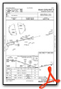
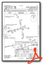
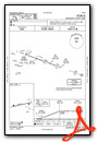
Instrument Approach Procedure (IAP) Charts
Nearby Airports with Instrument Procedures
| ID | Name | Heading / Distance | ||
|---|---|---|---|---|
 |
KPLD | Portland Municipal Airport | 350° | 17.3 |
|
KVES | Darke County Airport | 082° | 18.4 |
|
KMIE | Delaware County Regional Airport | 281° | 21.9 |
|
KRID | Richmond Municipal Airport | 170° | 25.0 |
|
KUWL | New Castle Henry County Marlatt Field Airport | 226° | 25.2 |
|
KCQA | Lakefield Airport | 041° | 25.5 |
|
I17 | Piqua/Hartzell Field Airport | 090° | 28.6 |
|
3I7 | Dayton/Phillipsburg Airport | 121° | 28.8 |
|
KCEV | Mettel Field Airport | 198° | 29.6 |
|
KAID | Anderson Municipal-Darlington Field Airport | 263° | 31.7 |
|
KAXV | Neil Armstrong Airport | 055° | 34.9 |
|
KSCA | Sidney Municipal Airport | 082° | 36.2 |
Airport Images
Do you have a recent image of this airport? Upload it here!


