Login
Register


I66
Clinton Field Airport
Official FAA Data Effective 2024-04-18 0901Z
Chart Supplement

VFR Chart of I66
Sectional Charts at SkyVector.com
IFR Chart of I66
Enroute Charts at SkyVector.com
Location Information for I66
Coordinates: N39°30.15' / W83°51.80'Located 04 miles NW of Wilmington, Ohio on 54 acres of land. View all Airports in Ohio.
Surveyed Elevation is 1033 feet MSL.
Operations Data
|
|
Airport Communications
| AWOS-3: | 124.175 Tel. 937-382-1376 |
|---|---|
| COLUMBUS APPROACH: | 118.85 269.275 |
| COLUMBUS DEPARTURE: | 118.85 269.275 |
| IC: | 269.275 |
| CTAF: | 122.725 |
| UNICOM: | 122.725 |
| D-ATIS at ILN (5.6 SE): | 124.925 |
| ASOS at ILN (5.6 SE): | 937-383-7334 |
| AWOS-3 at GDK (12.9 NW): | 118.525 937-372-4668 |
Nearby Navigation Aids
|
| ||||||||||||||||||||||||||||||||||||||||||||||||||||||||||||


Runway 03/21
| Dimensions: | 3579 x 60 feet / 1091 x 18 meters | |
|---|---|---|
| Surface: | Asphalt in Excellent Condition | |
| Weight Limits: | S-12 | |
| Edge Lighting: | Medium Intensity | |
| Runway 03 | Runway 21 | |
| Coordinates: | N39°29.89' / W83°51.98' | N39°30.41' / W83°51.62' |
| Elevation: | 1025.2 | 1030.7 |
| Traffic Pattern: | Left | Left |
| Runway Heading: | 28° True | 208° True |
| Markings: | Non-Precision Instrument in good condition. | Non-Precision Instrument in good condition. |
| Glide Slope Indicator | P2L (3.00° Glide Path Angle) | P2L (3.75° Glide Path Angle) PAPI UNUSBL BYD 5 DEGS RIGHT OF CNTRLN. |
| Obstacles: | 55 ft Trees 460 ft from runway, 256 ft right of center | 72 ft Trees 1121 ft from runway, 269 ft right of center +52 FT TREE, 94 FT DIST, 220 FT L. |
Services Available
| Fuel: | 100LL (blue) |
|---|---|
| Transient Storage: | Hangars,Tiedowns FOR AVBLTY CALL 937-382-2889. |
| Airframe Repair: | NONE |
| Engine Repair: | NONE |
| Bottled Oxygen: | NONE |
| Bulk Oxygen: | NONE |
| Other Services: | PILOT INSTRUCTION,AIRCRAFT RENTAL |
Ownership Information
| Ownership: | Publicly owned | |
|---|---|---|
| Owner: | CLINTON CO BOARD OF COMM | |
| 46 S SOUTH ST | ||
| WILMINGTON, OH 45177-2245 | ||
| 937-382-2103 | ||
| Manager: | MELODY WALDMANN | CLINTONCOUNTYAIRPORT@YAHOO.COM. |
| 1581 N CURRY RD | ||
| WILMINGTON, OH 45177-9048 | ||
| 937-382-4638 | CELL 937-725-1946. | |
Operational Statistics
| Single Engine Aircraft Based on Field: | 25 | Statistics collected for 12 month period ending 2022-08-24 | |
|---|---|---|---|
| Multi-Engine Aircraft Based on Field: | 2 | Annual Commercial Operations: | none |
| Jet Aircraft Based on Field: | none | Annual Commuter Operations: | none |
| Helicopters Based on Field: | none | Annual Air Taxi Operations: | 500 |
| Military Aircraft Based on Field: | none | Annual Military Operations: | 10 |
| Gliders Based on Field: | 1 | Annual GA Local Operations: | 19500 |
| Ultralights Based on Field: | none | Annual GA Itinerant Operations: | 7000 |
Other Remarks
- DEER & BIRDS ON & INVOF ARPT.
- FOR CD CTC COLUMBUS APCH AT 614-338-8537.
- 0LL AVBL SELF SVC VIA CREDIT CARD ONLY.
- ROPES NOT PRVDD.
- ACTVT MIRL RWY 03/21 - CTAF. PAPI RWY 03 & 21 OPR CONSLY.
Weather Minimums

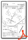
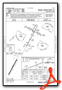
Instrument Approach Procedure (IAP) Charts
Nearby Airports with Instrument Procedures
| ID | Name | Heading / Distance | ||
|---|---|---|---|---|
 |
KILN | Wilmington Air Park Airport | 143° | 5.6 |
|
KGDK | Greene County/Lewis A Jackson Regional Airport | 332° | 12.8 |
|
KMGY | Dayton/Wright Brothers Airport | 287° | 17.6 |
|
I68 | Warren County/John Lane Field Airport | 262° | 18.2 |
|
KSGH | Springfield/Beckley Municipal Airport | 003° | 20.3 |
|
I73 | Moraine Air Park Airport | 301° | 20.5 |
|
I23 | Fayette County Airport | 078° | 21.0 |
|
KFFO | Wright-Patterson AFB Airport | 336° | 21.2 |
|
KHOC | Highland County Airport | 141° | 24.1 |
|
KMWO | Middletown Regional/Hook Field Airport | 274° | 24.8 |
|
KDAY | James M Cox Dayton International Airport | 325° | 29.1 |
|
I69 | Clermont County Airport | 212° | 30.1 |
Airport Images

By: Daun


