Login
Register


ICR
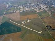
Winner Regional Airport
Official FAA Data Effective 2024-04-18 0901Z
Chart Supplement

VFR Chart of KICR
Sectional Charts at SkyVector.com
IFR Chart of KICR
Enroute Charts at SkyVector.com
Location Information for KICR
Coordinates: N43°23.37' / W99°50.47'Located 01 miles NE of Winner, South Dakota on 226 acres of land. View all Airports in South Dakota.
Estimated Elevation is 2032 feet MSL.
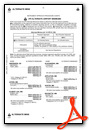
Operations Data
|
|
Airport Communications
| ASOS: | 126.775 Tel. 605-842-3989 |
|---|---|
| UNICOM: | 122.800 |
| CTAF: | 122.800 |
| AWOS-3P at 9V9 (32.0 NE): | 118.025 605-234-1437 |
| ASOS at VTN (44.5 SW): | 118.075 402-376-1673 |
| AWOS-3P at SUO (45.3 W): | 119.075 605-747-2392 |
- APCH/DEP SVC PRVDD BY MINNEAPOLIS ARTCC (ZMP) ON FREQ 125.1/269.1 (PIERRE RCAG).
Nearby Navigation Aids
|
| ||||||||||||||||||||||||||||||||||||||||||||||||


Runway 13/31
| Dimensions: | 5500 x 75 feet / 1676 x 23 meters | |
|---|---|---|
| Surface: | Concrete in Excellent Condition | |
| Weight Limits: | 17 /R/B/W/T, S-51, D-68 | |
| Edge Lighting: | Medium Intensity | |
| Runway 13 | Runway 31 | |
| Coordinates: | N43°23.65' / W99°50.84' | N43°23.01' / W99°49.96' |
| Elevation: | 2011.4 | 2024.7 |
| Traffic Pattern: | Left | Left |
| Runway Heading: | 135° True | 315° True |
| Markings: | Non-Precision Instrument in good condition. | Non-Precision Instrument in good condition. |
| Glide Slope Indicator | P2L (3.00° Glide Path Angle) | P2L (3.00° Glide Path Angle) |
Runway 03/21
CLSD WINTER MONTHS. | ||
| Dimensions: | 2751 x 150 feet / 839 x 46 meters | |
|---|---|---|
| Surface: | Turf in Good Condition | |
| Runway 03 | Runway 21 | |
| Coordinates: | N43°23.28' / W99°50.81' | N43°23.64' / W99°50.43' |
| Elevation: | 2032.3 | 2002.4 |
| Traffic Pattern: | Left | Left |
| Runway Heading: | 38° True | 218° True |
| Obstacles: | 5 ft Fence 100 ft from runway | |
Services Available
| Fuel: | 100LL (blue), Jet-A |
|---|---|
| Transient Storage: | Hangars,Tiedowns |
| Airframe Repair: | MAJOR |
| Engine Repair: | MAJOR |
| Bottled Oxygen: | NONE |
| Bulk Oxygen: | NONE |
| Other Services: | CROP DUSTING SERVICES,PILOT INSTRUCTION |
Ownership Information
| Ownership: | Publicly owned | |
|---|---|---|
| Owner: | CITY OF WINNER | |
| PO BOX 691 | ||
| WINNER, SD 57580 | ||
| 605-842-2606 | ||
| Manager: | DAVE HOWARD | |
| RR 2 BOX 100 | ||
| WINNER, SD 57580 | ||
| 605-842-0740 | ALT MGR PH# CELL-605-670-0234. | |
Operational Statistics
| Single Engine Aircraft Based on Field: | 16 | Statistics collected for 12 month period ending 2019-06-20 | |
|---|---|---|---|
| Multi-Engine Aircraft Based on Field: | 1 | Annual Commercial Operations: | none |
| Jet Aircraft Based on Field: | none | Annual Commuter Operations: | none |
| Helicopters Based on Field: | none | Annual Air Taxi Operations: | 60 |
| Military Aircraft Based on Field: | none | Annual Military Operations: | none |
| Gliders Based on Field: | none | Annual GA Local Operations: | 6800 |
| Ultralights Based on Field: | none | Annual GA Itinerant Operations: | 10000 |
Other Remarks
- HIGH AIR TFC OCT-NOV.
- GCO AVBL ON FREQ 121.725 (4 CLICKS TO MINNEAPOLIS CENTER)
- FOR CD IF UNA VIA GCO CTC MINNEAPOLIS ARTCC AT 651-463-5588.
- RWY 03/21 MARKED WITH BLACK AND WHITE CONES.
- ACTVT PAPI RY 13/31; MIRL RY 13/31 - CTAF.
Weather Minimums
Instrument Approach Procedure (IAP) Charts
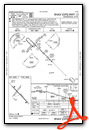
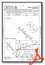
Nearby Airports with Instrument Procedures
| ID | Name | Heading / Distance | ||
|---|---|---|---|---|
 |
9D1 | Gregory Municipal - Flynn Field Airport | 117° | 21.7 |
|
9V9 | Chamberlain Municipal Airport | 044° | 32.0 |
|
KVTN | Miller Field Airport | 224° | 44.6 |
|
KSUO | Rosebud Sioux Tribal Airport | 260° | 45.3 |
|
KANW | Ainsworth Regional Airport | 187° | 49.1 |
|
KRBE | Rock County Airport | 166° | 50.5 |
|
8V2 | Stuart-Atkinson Municipal Airport | 144° | 60.9 |
|
KPIR | Pierre Regional Airport | 342° | 62.6 |
|
4X4 | Wessington Springs Airport | 054° | 69.8 |
|
KAGZ | Wagner Municipal Airport | 105° | 70.5 |
|
9D0 | Highmore Municipal Airport | 013° | 71.1 |
|
KONL | The O'Neill Municipal-John L Baker Field Airport | 136° | 75.0 |
Airport Images
By: jcbecker@pie.mi...


