Login
Register


IGM
Kingman Airport
Official FAA Data Effective 2024-03-21 0901Z
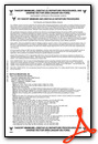
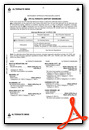
Chart Supplement

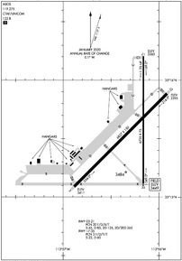
KIGM Airport Diagram
VFR Chart of KIGM
Sectional Charts at SkyVector.com
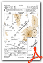
IFR Chart of KIGM
Enroute Charts at SkyVector.com
Location Information for KIGM
Coordinates: N35°15.57' / W113°56.28'Located 08 miles NE of Kingman, Arizona on 4200 acres of land. View all Airports in Arizona.
Surveyed Elevation is 3448 feet MSL.
Operations Data
|
|
Airport Communications
| ASOS: | 119.275 Tel. 928-692-8104 |
|---|---|
| CTAF: | 122.800 |
| UNICOM: | 122.800 |
| ATIS at IFP (31.1 W): | 119.825 |
| AWOS-3PT at IFP (31.3 W): | 119.825 928-754-4462 |
| AWOS-3PT at 1G4 (44.2 N): | 119.425 928-237-1354 |
- COMMUNICATIONS PRVDD BY PRESCOTT RADIO ON FREQ 122.1R (KINGMAN RCO).
- APCH/DEP CTL SVC PRVDD BY LOS ANGELES ARTCC (ZLC) ON 124.85/319.2 (SELIGMAN RCAG).
Nearby Navigation Aids
|
| ||||||||||||||||||||||||||||||||||||


Runway 03/21
| Dimensions: | 6827 x 150 feet / 2081 x 46 meters | |
|---|---|---|
| Surface: | Asphalt in Good Condition | |
| Weight Limits: | 20 /F/D/X/T, S-45, D-85, ST-125, DT-265 | |
| Edge Lighting: | Medium Intensity | |
| Runway 03 | Runway 21 | |
| Coordinates: | N35°15.09' / W113°56.89' | N35°15.88' / W113°55.92' |
| Elevation: | 3411.4 | 3394.6 |
| Traffic Pattern: | Left | Left |
| Runway Heading: | 45° True | 225° True |
| Declared Distances: | TORA:6827 TODA:6827 ASDA:6827 LDA:6827 | TORA:6827 TODA:6827 ASDA:6827 LDA:6827 |
| Markings: | Non-Precision Instrument in good condition. | Non-Precision Instrument in good condition. |
| Glide Slope Indicator | P4L (3.00° Glide Path Angle) | P4L (3.00° Glide Path Angle) |
| REIL: | Yes | Yes |
Runway 17/35
| Dimensions: | 6725 x 75 feet / 2050 x 23 meters | |
|---|---|---|
| Surface: | Asphalt in Good Condition | |
| Weight Limits: | 3 /F/D/Y/T, S-22, D-60 | |
| Edge Lighting: | Medium Intensity | |
| Runway 17 | Runway 35 | |
| Coordinates: | N35°16.21' / W113°56.16' | N35°15.10' / W113°56.16' |
| Elevation: | 3360.0 | 3448.8 |
| Traffic Pattern: | Left | Left |
| Runway Heading: | 180° True | 0 |
| Declared Distances: | TORA:6725 TODA:6725 ASDA:6725 LDA:6725 | TORA:6725 TODA:6725 ASDA:6725 LDA:6725 |
| Markings: | Basic in good condition. | Basic in good condition. |
| Glide Slope Indicator | P2L (3.00° Glide Path Angle) | P2L (3.00° Glide Path Angle) |
Services Available
| Fuel: | 100LL (blue), Jet-A |
|---|---|
| Transient Storage: | Tiedowns |
| Airframe Repair: | MAJOR |
| Engine Repair: | MAJOR |
| Bottled Oxygen: | NONE |
| Bulk Oxygen: | HIGH/LOW |
| Other Services: | AIR FREIGHT SERVICES,AIR AMBULANCE SERVICES,AIRCRAFT RENTAL |
Ownership Information
| Ownership: | Publicly owned | |
|---|---|---|
| Owner: | CITY OF KINGMAN | |
| 7000 FLIGHTLINE DR | ||
| KINGMAN, AZ 86401 | ||
| 928-757-2134 | ||
| Manager: | DOUG BRECKENRIDGE | |
| 7000 FLIGHTLINE DR. | ||
| KINGMAN, AZ 86401 | ||
| 928-757-2134 | FAX: 928-757-9871. | |
Operational Statistics
| Single Engine Aircraft Based on Field: | 65 | Statistics collected for 12 month period ending 2016-01-31 | |
|---|---|---|---|
| Multi-Engine Aircraft Based on Field: | 12 | Annual Commercial Operations: | 1358 |
| Jet Aircraft Based on Field: | none | Annual Commuter Operations: | none |
| Helicopters Based on Field: | 1 | Annual Air Taxi Operations: | 1100 |
| Military Aircraft Based on Field: | none | Annual Military Operations: | 20 |
| Gliders Based on Field: | 2 | Annual GA Local Operations: | 14000 |
| Ultralights Based on Field: | none | Annual GA Itinerant Operations: | 12000 |
Other Remarks
- RWY 21 CALM WIND RWY.
- DISTANCE REMAINING SIGNS RIGHT SIDE RWY 03, LEFT SIDE RWY 21.
- ULTRALIGHT & MODEL AIRPLANE ACTVT NW OF ARPT.
- FOR CD IF UNA TO CTC ON FSS FREQ, CTC LOS ANGELES ARTCC AT 661-575-2079.
- VEHICLE AND PEDESTRIAN GATE CODE IS THE PUBLISHED LENGTH OF RWY 03/21.
- ACTVT REIL RWY 03 & 21; PAPI RWY 03 & 21; MIRL RWY 03/21 & 17/35; TWY LGTS - CTAF.
Weather Minimums
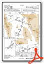
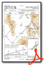
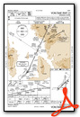
Instrument Approach Procedure (IAP) Charts
Nearby Airports with Instrument Procedures
| ID | Name | Heading / Distance | ||
|---|---|---|---|---|
 |
KIFP | Laughlin/Bullhead International Airport | 258° | 31.2 |
|
KEED | Needles Airport | 229° | 44.9 |
|
KHII | Lake Havasu City Airport | 206° | 46.2 |
|
KBVU | Boulder City Municipal Airport | 312° | 61.1 |
|
P20 | Avi Suquilla Airport | 193° | 68.4 |
|
KHND | Henderson Exec Airport | 306° | 72.5 |
|
KLAS | Harry Reid International Airport | 309° | 77.1 |
|
KLSV | Nellis AFB Airport | 317° | 79.3 |
|
KPRC | Prescott Regional - Ernest A Love Field Airport | 115° | 83.2 |
|
KVGT | North Las Vegas Airport | 313° | 83.7 |
|
KCMR | H A Clark Memorial Field Airport | 087° | 85.7 |
|
40G | Valle Airport | 074° | 90.8 |
Airport Images
Do you have a recent image of this airport? Upload it here!


