Login
Register


IKW
Jack Barstow Airport
Official FAA Data Effective 2024-04-18 0901Z
Chart Supplement

VFR Chart of KIKW
Sectional Charts at SkyVector.com
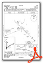
IFR Chart of KIKW
Enroute Charts at SkyVector.com
Location Information for KIKW
Coordinates: N43°39.78' / W84°15.68'Located 03 miles NW of Midland, Michigan on 512 acres of land. View all Airports in Michigan.
Surveyed Elevation is 634 feet MSL.
Operations Data
|
|
Airport Communications
| AWOS-3: | 119.525 Tel. 989-835-5841 |
|---|---|
| GREAT LAKES APPROACH: | 126.45 235.625 |
| GREAT LAKES DEPARTURE: | 126.45 235.625 |
| UNICOM: | 122.800 |
| CTAF: | 122.800 |
| ASOS at MBS (11.1 SE): | 989-695-2488 |
| ATIS at MBS (11.1 SE): | 125.925 |
| AWOS-3 at MOP (20.8 W): | 133.025 989-773-2885 |
- APCH/DEP SVC PRVDD BY CLEVELAND ARTCC (ZOB) ON FREQS 127.7/290.425 (FREELAND RCAG) WHEN GREAT LAKES APCH CTL CLSD.
Nearby Navigation Aids
|
| ||||||||||||||||||||||||||||||||||||||||||||||||||||||||||||


Runway 06/24
| Dimensions: | 3801 x 75 feet / 1159 x 23 meters | |
|---|---|---|
| Surface: | Asphalt in Good Condition | |
| Weight Limits: | S-24 | |
| Edge Lighting: | Medium Intensity | |
| Runway 06 | Runway 24 | |
| Coordinates: | N43°39.61' / W84°15.92' | N43°39.93' / W84°15.17' |
| Elevation: | 621.2 | 634.7 |
| Traffic Pattern: | Left | Left |
| Runway Heading: | 60° True | 240° True |
| Markings: | Non-Precision Instrument in fair condition. | Non-Precision Instrument in fair condition. |
| Glide Slope Indicator | P2L (3.00° Glide Path Angle) | P2L (3.00° Glide Path Angle) |
| REIL: | Yes | Yes |
| Obstacles: | 42 ft Tree 715 ft from runway, 110 ft left of center | 65 ft Tree 1276 ft from runway, 75 ft left of center |
Runway 18/36
| Dimensions: | 3001 x 75 feet / 915 x 23 meters | |
|---|---|---|
| Surface: | Asphalt in Good Condition | |
| Weight Limits: | S-24 | |
| Edge Lighting: | Medium Intensity | |
| Runway 18 | Runway 36 | |
| Coordinates: | N43°40.03' / W84°15.85' | N43°39.54' / W84°15.85' |
| Elevation: | 627.8 | 621.1 |
| Traffic Pattern: | Left | Left |
| Runway Heading: | 180° True | 0 |
| Markings: | Non-Precision Instrument in fair condition. | Non-Precision Instrument in fair condition. |
| Glide Slope Indicator | P2L (3.30° Glide Path Angle) | P2L (3.30° Glide Path Angle) |
| REIL: | Yes | Yes |
| Obstacles: | 70 ft Tree 1393 ft from runway, 80 ft left of center | 58 ft Tree 1226 ft from runway, 125 ft right of center |
Services Available
| Fuel: | 100LL (blue), Jet A+ |
|---|---|
| Transient Storage: | Hangars,Tiedowns FOR TSNT HNGR CALL AMGR. |
| Airframe Repair: | NONE |
| Engine Repair: | NONE |
| Bottled Oxygen: | NONE |
| Bulk Oxygen: | NONE |
| Other Services: | PILOT INSTRUCTION,AIRCRAFT RENTAL |
Ownership Information
| Ownership: | Publicly owned | |
|---|---|---|
| Owner: | CITY OF MIDLAND | |
| 333 W ELLSWORTH ST | ||
| MIDLAND, MI 48640-5132 | ||
| 989-837-3300 | ||
| Manager: | SARAH PAGANO | |
| 6603 BARSTOW DR | ||
| MIDLAND, MI 48642-7783 | ||
| 989-835-3231 | CELL 989-525-5206. | |
Operational Statistics
| Single Engine Aircraft Based on Field: | 44 | Statistics collected for 12 month period ending 2020-12-31 | |
|---|---|---|---|
| Multi-Engine Aircraft Based on Field: | 4 | Annual Commercial Operations: | none |
| Jet Aircraft Based on Field: | 1 | Annual Commuter Operations: | none |
| Helicopters Based on Field: | 2 | Annual Air Taxi Operations: | none |
| Military Aircraft Based on Field: | none | Annual Military Operations: | none |
| Gliders Based on Field: | none | Annual GA Local Operations: | 8000 |
| Ultralights Based on Field: | none | Annual GA Itinerant Operations: | 8000 |
Other Remarks
- DEER & LRG BIRDS ON & INVOF ARPT.
- OCNL ULTRALIGHT ACT.
- NOISE SENSITIVE AREA SOUTH OF ARPT, USE PREFERRED RWY 06/24.
- FOR CD CTC GREAT LAKES APCH AT 269-459-3345, WHEN APCH CLSD CTC CLEVELAND ARTCC AT 440-774-0224/0490.
- FLD CONDS UNMON WKDAYS 1800-0800 & WKENDS 1600-0800.
- 0LL 100LL & JET A+ SELF SVC; JET A+ AVBL FULL SVC BY PRIOR ARNGMT.
- ACTVT REIL RWY 06, 24, 18, & 36; PAPI RWY 06, 24, 18, & 36; MIRL RWY 06/24 & 18/36 - CTAF.
Weather Minimums
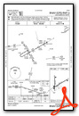
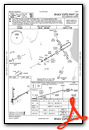
Instrument Approach Procedure (IAP) Charts
Nearby Airports with Instrument Procedures
| ID | Name | Heading / Distance | ||
|---|---|---|---|---|
 |
KMBS | Mbs International Airport | 134° | 11.1 |
|
3CM | James Clements Municipal Airport | 113° | 17.4 |
|
KGDW | Gladwin Zettel Memorial Airport | 333° | 20.7 |
|
KMOP | Mount Pleasant Municipal Airport | 263° | 20.9 |
|
KHYX | Saginaw County/H W Browne Airport | 128° | 22.2 |
|
48D | Clare Municipal Airport | 296° | 23.2 |
|
KAMN | Gratiot Community Airport | 222° | 27.7 |
|
Y31 | West Branch Community Airport | 005° | 35.1 |
|
KCFS | Tuscola Area Airport | 108° | 37.6 |
|
KRNP | Owosso Community Airport | 172° | 40.5 |
|
KHTL | Roscommon County/Blodgett Memorial Airport | 337° | 45.4 |
|
13C | Lakeview/Griffith Field Airport | 254° | 45.6 |
Airport Images

By: sunmanav8


