Login
Register


ILN
Wilmington Air Park Airport
Official FAA Data Effective 2024-04-18 0901Z
Chart Supplement

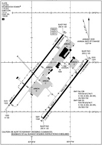
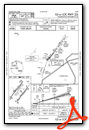
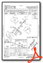
KILN Airport Diagram
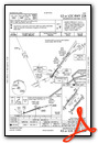
VFR Chart of KILN
Sectional Charts at SkyVector.com
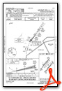
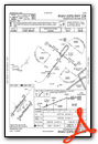
IFR Chart of KILN
Enroute Charts at SkyVector.com
Location Information for KILN
Coordinates: N39°25.68' / W83°47.53'Located 02 miles SE of Wilmington, Ohio on 2000 acres of land. View all Airports in Ohio.
Surveyed Elevation is 1076 feet MSL.
Operations Data
|
|
Airport Communications
| D-ATIS: | 124.925 |
|---|---|
| ASOS: | Tel. 937-383-7334 |
| WILMINGTON TOWER: | 119.475 |
| WILMINGTON GROUND: | 121.6 |
| COLUMBUS APPROACH: | 118.85 269.275 |
| COLUMBUS DEPARTURE: | 118.85 269.275 |
| IC: | 269.275 |
| CLEARANCE DELIVERY: | 128.85 |
| AWOS-3 at I66 (5.6 NW): | 124.175 937-382-1376 |
| AWOS-3 at GDK (18.4 NW): | 118.525 937-372-4668 |
| AWOS-3 at HOC (18.6 SE): | 118.175 937-393-9038 |
- NO EMERG FREQ
- SURFACE MOVEMENT GUIDANCE AND CONTROL SYSTEM NOT AVBL.
- ATCT OWNED & OPERATED BY AIRBORNE EXPRESS INC
Nearby Navigation Aids
|
| ||||||||||||||||||||||||||||||||||||||||||||||||||||||||||||


Runway 04L/22R
| Dimensions: | 10701 x 150 feet / 3262 x 46 meters HAS 1000 FT PAVED AREA ON SW END AND 200 FT PAVED AREA ON NE END. | |
|---|---|---|
| Surface: | Concrete / Grooved in Fair Condition | |
| Weight Limits: | 84 /R/C/W/T, S-100, D-200, ST-390, DT-750 | |
| Edge Lighting: | High Intensity | |
| Runway 04L | Runway 22R | |
| Coordinates: | N39°25.16' / W83°48.56' | N39°26.56' / W83°47.18' |
| Elevation: | 1053.0 | 1076.7 |
| Traffic Pattern: | Left | Left |
| Runway Heading: | 37° True | 217° True |
| Declared Distances: | TORA:10701 TODA:10701 ASDA:10701 LDA:10701 | TORA:10701 TODA:10701 ASDA:10701 LDA:10701 |
| Markings: | Precision Instrument in good condition. | Precision Instrument in good condition. |
| Glide Slope Indicator | P4L (3.00° Glide Path Angle) RY 04L PAPI RESTRICTED BYD 8 DEG LEFT & RIGHT OF CNTRLN. | P4L (3.00° Glide Path Angle) RY 22R PAPI-4L, RESTRICTED BYD 8 DEGS LEFT AND RIGHT OF CENTERLINE. |
| RVR Equipment | Touchdown Midfield Rollout | Touchdown Midfield Rollout |
| Approach Lights: | MALSR 1,400 Foot Medium-intensity Approach Lighting System with runway alignment indicator lights. | ALSF2 Standard 2,400 Foot High-intensity Approach Lighting System with sequenced flashers, CATEGORY II or III Configuration. |
| Centerline Lights: | Yes | Yes |
Runway 04R/22L
RY 04R/22L CLOSED UFN. | ||
| Dimensions: | 9000 x 150 feet / 2743 x 46 meters HAS 200 FT PAVED AREA EACH END. | |
|---|---|---|
| Surface: | Concrete / Grooved in Fair Condition | |
| Weight Limits: | 98 /R/B/W/T, S-100, D-200, ST-390, DT-750 | |
| Edge Lighting: | High Intensity | |
| Runway 04R | Runway 22L | |
| Coordinates: | N39°24.86' / W83°47.70' | N39°26.04' / W83°46.54' |
| Elevation: | 1042.5 | 1076.5 |
| Runway Heading: | 37° True | 217° True |
| Declared Distances: | TORA:9000 TODA:9000 ASDA:9000 LDA:9000 | TORA:9000 TODA:9000 ASDA:9000 LDA:9000 |
| Markings: | Precision Instrument in good condition. | Precision Instrument in good condition. |
| Glide Slope Indicator | P4L (3.00° Glide Path Angle) | P4L (3.00° Glide Path Angle) |
| RVR Equipment | Touchdown Midfield Rollout | Touchdown Midfield Rollout |
| Approach Lights: | MALSR 1,400 Foot Medium-intensity Approach Lighting System with runway alignment indicator lights. | ALSF2 Standard 2,400 Foot High-intensity Approach Lighting System with sequenced flashers, CATEGORY II or III Configuration. |
| Centerline Lights: | Yes | Yes |
Services Available
| Fuel: | Jet-A |
|---|---|
| Transient Storage: | NONE |
| Airframe Repair: | MAJOR |
| Engine Repair: | MAJOR |
| Bottled Oxygen: | NONE |
| Bulk Oxygen: | HIGH/LOW |
Ownership Information
| Ownership: | Publicly owned | |
|---|---|---|
| Owner: | CLINTON COUNTY PORT AUTHORITY | |
| 1113 AIRPORT RD | ||
| WILMINGTON, OH 45177-8904 | ||
| 937-536-1776 | ||
| Manager: | JEREMY HEARD | |
| 145 HUNTER DR | ||
| WILMINGTON, OH 45177-9550 | ||
| 937-366-2114 | ||
Operational Statistics
| Single Engine Aircraft Based on Field: | none | Statistics collected for 12 month period ending 2016-01-01 | |
|---|---|---|---|
| Multi-Engine Aircraft Based on Field: | none | Annual Commercial Operations: | 100 |
| Jet Aircraft Based on Field: | none | Annual Commuter Operations: | none |
| Helicopters Based on Field: | none | Annual Air Taxi Operations: | 900 |
| Military Aircraft Based on Field: | none | Annual Military Operations: | none |
| Gliders Based on Field: | none | Annual GA Local Operations: | none |
| Ultralights Based on Field: | none | Annual GA Itinerant Operations: | none |
Other Remarks
- 4 HR PPR FOR ALL TSNT ACFT DURG OPRG HRS & AFT HRS - CALL 866-931-2337.
- FOR CD CTC COLUMBUS APCH AT 614-338-8537.
- PAPI RWY 04L & 22R OPR CONSLY SS-SR. ALL RWY 04R/22L LGTS OTS INDEFLY.
Weather Minimums

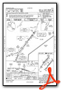
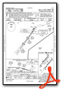
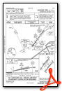
Instrument Approach Procedure (IAP) Charts


Nearby Airports with Instrument Procedures
| ID | Name | Heading / Distance | ||
|---|---|---|---|---|
 |
I66 | Clinton Field Airport | 323° | 5.6 |
|
KGDK | Greene County/Lewis A Jackson Regional Airport | 329° | 18.3 |
|
KHOC | Highland County Airport | 140° | 18.6 |
|
I23 | Fayette County Airport | 063° | 19.3 |
|
I68 | Warren County/John Lane Field Airport | 275° | 21.5 |
|
KMGY | Dayton/Wright Brothers Airport | 295° | 22.3 |
|
KSGH | Springfield/Beckley Municipal Airport | 354° | 24.8 |
|
I73 | Moraine Air Park Airport | 306° | 25.8 |
|
KFFO | Wright-Patterson AFB Airport | 333° | 26.6 |
|
I69 | Clermont County Airport | 223° | 28.6 |
|
KMWO | Middletown Regional/Hook Field Airport | 282° | 28.8 |
|
KGEO | Brown County Airport | 187° | 33.0 |
Airport Images
Do you have a recent image of this airport? Upload it here!


