Login
Register


IRK
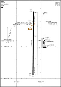
Kirksville Regional Airport
Official FAA Data Effective 2024-04-18 0901Z
Chart Supplement

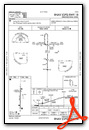
KIRK Airport Diagram
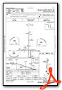
VFR Chart of KIRK
Sectional Charts at SkyVector.com
IFR Chart of KIRK
Enroute Charts at SkyVector.com
Location Information for KIRK
Coordinates: N40°5.61' / W92°32.70'Located 06 miles SE of Kirksville, Missouri on 476 acres of land. View all Airports in Missouri.
Surveyed Elevation is 966 feet MSL.
Operations Data
|
|
Airport Communications
| ASOS: | 121.125 Tel. 660-627-6059 |
|---|---|
| CTAF: | 122.800 |
| UNICOM: | 122.800 |
| AWOS-2 at MO8 (29.0 SW): | 118.425 660-258-2151 |
| AWOS-3PT at MBY (38.2 S): | 120.025 660-269-8028 |
| AWOS-3 at TVK (38.9 NW): | 123.775 641-437-1213 |
- COMMUNICATIONS PRVDD BY COLUMBIA RADIO ON FREQ 122.2 (KIRKSVILLE RCO).
- APCH/DEP SVC PRVDD BY KANSAS CITY ARTCC ON FREQS 132.6/370.9 (KIRKSVILLE RCAG).
Nearby Navigation Aids
|
| ||||||||||||||||||||||||||||||||||||||||||||||||||||||


Runway 18/36
| Dimensions: | 6005 x 100 feet / 1830 x 30 meters | |
|---|---|---|
| Surface: | Concrete in Fair Condition | |
| Weight Limits: | 10 /R/D/W/T, S-30, D-48, ST-85 | |
| Edge Lighting: | High Intensity | |
| Runway 18 | Runway 36 | |
| Coordinates: | N40°6.04' / W92°32.65' | N40°5.06' / W92°32.66' |
| Elevation: | 966.2 | 963.7 |
| Traffic Pattern: | Left | Left |
| Runway Heading: | 180° True | 0 |
| Declared Distances: | TORA:6005 TODA:6005 ASDA:6005 LDA:6005 | TORA:6005 TODA:6005 ASDA:6005 LDA:6005 |
| Markings: | Non-Precision Instrument in fair condition. | Precision Instrument in fair condition. |
| Glide Slope Indicator | V4L (3.00° Glide Path Angle) | V4L (3.00° Glide Path Angle) |
| Approach Lights: | MALSR 1,400 Foot Medium-intensity Approach Lighting System with runway alignment indicator lights. | |
| REIL: | Yes | |
Runway 09/27
| Dimensions: | 1370 x 100 feet / 418 x 30 meters | |
|---|---|---|
| Surface: | Turf in Good Condition | |
| Runway 09 | Runway 27 | |
| Coordinates: | N40°5.87' / W92°33.00' | N40°5.87' / W92°32.71' |
| Elevation: | 959.0 | 964.2 |
| Traffic Pattern: | Left | Left |
| Runway Heading: | 91° True | 271° True |
| Obstacles: | 72 ft Trees 1440 ft from runway | 47 ft Trees 1240 ft from runway |
Services Available
| Fuel: | 100LL (blue), Jet-A |
|---|---|
| Transient Storage: | Hangars,Tiedowns |
| Airframe Repair: | MAJOR |
| Engine Repair: | MAJOR |
| Bottled Oxygen: | NONE |
| Bulk Oxygen: | NONE |
| Other Services: | AIR FREIGHT SERVICES,AVIONICS,CARGO HANDLING SERVICES,CHARTER SERVICE,PILOT INSTRUCTION,AIRCRAFT RENTAL,AIRCRAFT SALES |
Ownership Information
| Ownership: | Publicly owned | |
|---|---|---|
| Owner: | CITY OF KIRKSVILLE | |
| CITY HALL, 201 SOUTH FRANKLIN | ||
| KIRKSVILLE, MO 63501 | ||
| 660-627-1225 | ||
| Manager: | JEFFERY LAFOUNTAIN | AIRPORT DIRECTOR |
| 27161 DAVID HALL TRAIL | ||
| KIRKSVILLE, MO 63501 | ||
| 660-665-5020 | ||
Operational Statistics
| Single Engine Aircraft Based on Field: | 16 | Statistics collected for 12 month period ending 2023-04-30 | |
|---|---|---|---|
| Multi-Engine Aircraft Based on Field: | none | Annual Commercial Operations: | 2190 |
| Jet Aircraft Based on Field: | 1 | Annual Commuter Operations: | none |
| Helicopters Based on Field: | none | Annual Air Taxi Operations: | 730 |
| Military Aircraft Based on Field: | none | Annual Military Operations: | 48 |
| Gliders Based on Field: | none | Annual GA Local Operations: | 920 |
| Ultralights Based on Field: | none | Annual GA Itinerant Operations: | 2000 |
Other Remarks
- FOR CD IF UNA TO CTC ON FSS FREQ, CTC KANSAS CITY ARTCC AT 913-254-8508.
- 09/27 MARKED WITH YELLOW CONES.
- ACTVT HIRL RY 18/36; VASI RYS 18 & 36; REIL RY 18 & MALSR RY 36 - CTAF.
Weather Minimums
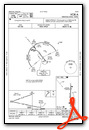
Instrument Approach Procedure (IAP) Charts
Nearby Airports with Instrument Procedures
| ID | Name | Heading / Distance | ||
|---|---|---|---|---|
 |
K89 | Macon-Fower Memorial Airport | 169° | 22.2 |
|
03D | Memphis Memorial Airport | 034° | 25.8 |
|
MO8 | North Central Missouri Regional Airport | 228° | 29.0 |
|
KMBY | Omar N Bradley Airport | 171° | 38.2 |
|
4K6 | Bloomfield Municipal Airport | 007° | 38.7 |
|
KTVK | Centerville Municipal Airport | 335° | 39.0 |
|
6M6 | Lewis County Regional Airport | 086° | 40.0 |
|
K52 | Cpt Ben Smith Airfield - Monroe City Airport | 125° | 46.7 |
|
KCHT | Chillicothe Municipal Airport | 247° | 47.7 |
|
KTRX | Trenton Municipal Airport | 269° | 48.2 |
|
4C8 | Albia Municipal Airport | 349° | 55.1 |
|
KHAE | Hannibal Regional Airport | 113° | 55.4 |
Airport Images
Do you have a recent image of this airport? Upload it here!


