Login
Register


ITR
Kit Carson County Airport
Official FAA Data Effective 2024-04-18 0901Z
Chart Supplement

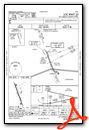
VFR Chart of KITR
Sectional Charts at SkyVector.com
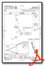
IFR Chart of KITR
Enroute Charts at SkyVector.com
Location Information for KITR
Coordinates: N39°14.55' / W102°17.12'Located 03 miles S of Burlington, Colorado on 684 acres of land. View all Airports in Colorado.
Surveyed Elevation is 4218 feet MSL.
Operations Data
|
|
Airport Communications
| ASOS: | 135.225 Tel. 719-346-7036 |
|---|---|
| UNICOM: | 122.800 |
| CTAF: | 122.800 |
| ASOS at GLD (28.5 E): | 121.025 785-899-6591 |
| AWOS-3 at SYF (38.5 NE): | 118.925 785-772-1411 |
| AWOS-3 at 2V5 (51.5 N): | 118.250 970-332-5930 |
- APCH/DEP CTL SVC PRVDD BY DENVER ARTCC (ZDV) ON FREQS 132.7/226.675 (GOODLAND RCAG).
Nearby Navigation Aids
|
| ||||||||||||||||||||||||||||||||||||||||||||||||||||||||||||


Runway 15/33
| Dimensions: | 5199 x 75 feet / 1585 x 23 meters | |
|---|---|---|
| Surface: | Asphalt in Good Condition | |
| Weight Limits: | S-17, D-17 | |
| Edge Lighting: | Medium Intensity | |
| Runway 15 | Runway 33 | |
| Coordinates: | N39°14.95' / W102°17.31' | N39°14.15' / W102°16.93' |
| Elevation: | 4218.3 | 4201.5 |
| Runway Heading: | 160° True | 340° True |
| Markings: | Non-Precision Instrument in good condition. | Non-Precision Instrument in good condition. |
| Glide Slope Indicator | P4L (3.00° Glide Path Angle) | P4L (3.00° Glide Path Angle) |
| REIL: | Yes | Yes |
Services Available
| Fuel: | 100LL (blue), Jet A-1+ |
|---|---|
| Transient Storage: | Hangars,Tiedowns |
| Airframe Repair: | MAJOR |
| Engine Repair: | MAJOR |
| Bottled Oxygen: | NONE |
| Bulk Oxygen: | NONE |
| Other Services: | CROP DUSTING SERVICES |
Ownership Information
| Ownership: | Publicly owned | |
|---|---|---|
| Owner: | CITY OF BURLINGTON | |
| 415 15TH STREET | ||
| BURLINGTON, CO 80807 | ||
| 719-346-8652 | ||
| Manager: | DANIEL MELIA | |
| 14111 HWY 385 | ||
| BURLINGTON, CO 80807 | ||
| 719-346-5352 | ||
Operational Statistics
| Single Engine Aircraft Based on Field: | 20 | Statistics collected for 12 month period ending 2016-12-31 | |
|---|---|---|---|
| Multi-Engine Aircraft Based on Field: | none | Annual Commercial Operations: | none |
| Jet Aircraft Based on Field: | none | Annual Commuter Operations: | none |
| Helicopters Based on Field: | none | Annual Air Taxi Operations: | none |
| Military Aircraft Based on Field: | none | Annual Military Operations: | 87 |
| Gliders Based on Field: | none | Annual GA Local Operations: | 3200 |
| Ultralights Based on Field: | none | Annual GA Itinerant Operations: | 4713 |
Other Remarks
- BE ALERT; INTENSIVE USAF STUDENT TRAINING IN VICINITY OF COLORADO SPRINGS & PUEBLO COLORADO.
- TXY MARKED WITH BLUE REFLECTORS.
- FOR CD CTC DENVER ARTCC AT 303-651-4257.
- 0LL 24 HR SELF SERVE FUEL AVBL.
- ACTVT MIRL RY 15/33; PAPI AND REIL RYS 15 & 33 - CTAF.
Weather Minimums
Instrument Approach Procedure (IAP) Charts
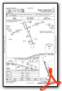
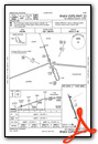
Nearby Airports with Instrument Procedures
| ID | Name | Heading / Distance | ||
|---|---|---|---|---|
 |
KGLD | Renner Field/Goodland Municipal Airport | 074° | 28.4 |
|
KSYF | Cheyenne County Municipal Airport | 036° | 38.5 |
|
2V5 | Wray Municipal Airport | 002° | 51.5 |
|
5K2 | Tribune Municipal Airport | 151° | 53.6 |
|
2V6 | Yuma Municipal Airport | 339° | 55.4 |
|
KCBK | Shalz Field Airport | 078° | 58.7 |
|
KLIC | Limon Municipal Airport | 272° | 64.4 |
|
3K7 | Mark Hoard Memorial Airport | 136° | 64.3 |
|
KADT | Atwood-Rawlins County City-County Airport | 057° | 67.9 |
|
KOEL | Oakley Municipal Airport | 096° | 69.0 |
|
KAKO | Colorado Plains Regional Airport | 322° | 70.8 |
|
KLAA | Southeast Colorado Regional Airport | 195° | 72.8 |
Airport Images
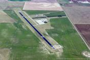
By: dmelia

By: brb


Comments
Great Fuel Stop
Good runway and ramp. Fuel is available at a competitive price. There is a nice pilot's lounge and courtesy car available. The facility was unmanned during my visit.