Login
Register


IXD
New Century Aircenter Airport
Official FAA Data Effective 2024-04-18 0901Z
From the Flight Deck
Chart Supplement

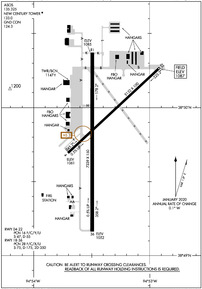
KIXD Airport Diagram
VFR Chart of KIXD
Sectional Charts at SkyVector.com
IFR Chart of KIXD
Enroute Charts at SkyVector.com
Location Information for KIXD
Coordinates: N38°49.86' / W94°53.42'Located 04 miles SW of Olathe, Kansas on 2600 acres of land. View all Airports in Kansas.
Surveyed Elevation is 1087 feet MSL.
Operations Data
|
|
Airport Communications
| ASOS: | 135.325 Tel. 913-780-6987 |
|---|---|
| NEW CENTURY TOWER: | 133.0 |
| NEW CENTURY GROUND: | 124.3 |
| KANSAS CITY APPROACH: | 118.9 251.075 |
| KANSAS CITY DEPARTURE: | 118.9 251.075 |
| ARMY OPS: | 347.5 46.9FM |
| UNICOM: | 122.950 |
| BRAYMER STAR: | 120.95 318.1 |
| JHAWK STAR: | 120.95 318.1 |
| CTAF: | 133.000 |
| TYGER STAR: | 120.95 318.1 |
| ASOS at OJC (7.2 E): | 913-780-6969 |
| ATIS at OJC (7.2 E): | 119.35 |
| ASOS at LWC (18.7 NW): | 121.225 785-749-1309 |
Nearby Navigation Aids
|
| ||||||||||||||||||||||||||||||||||||||||||||||||||||||||||||


Runway 18/36
| Dimensions: | 7339 x 150 feet / 2237 x 46 meters | |
|---|---|---|
| Surface: | Asphalt in Good Condition | |
| Weight Limits: | 28 /F/C/X/U, S-75, D-175, ST-350 | |
| Edge Lighting: | High Intensity | |
| Runway 18 | Runway 36 | |
| Coordinates: | N38°50.37' / W94°53.49' | N38°49.16' / W94°53.50' |
| Elevation: | 1084.9 | 1051.5 |
| Traffic Pattern: | Left | Right |
| Runway Heading: | 180° True | 0 |
| Markings: | Precision Instrument in good condition. | Precision Instrument in good condition. |
| Glide Slope Indicator | V2L (3.00° Glide Path Angle) | |
| Approach Lights: | MALSR 1,400 Foot Medium-intensity Approach Lighting System with runway alignment indicator lights. | |
| REIL: | Yes | |
Runway 04/22
| Dimensions: | 5132 x 100 feet / 1564 x 30 meters | |
|---|---|---|
| Surface: | Asphalt in Fair Condition | |
| Weight Limits: | 16 /F/C/Y/U, S-47, D-55 | |
| Edge Lighting: | Medium Intensity | |
| Runway 04 | Runway 22 | |
| Coordinates: | N38°49.69' / W94°53.70' | N38°50.27' / W94°52.91' |
| Elevation: | 1061.1 | 1087.2 |
| Traffic Pattern: | Right | Left |
| Runway Heading: | 47° True | 227° True |
| Markings: | Non-Precision Instrument in good condition. | Non-Precision Instrument in good condition. |
| Glide Slope Indicator | P4L (3.00° Glide Path Angle) | P4L (3.00° Glide Path Angle) |
Services Available
| Fuel: | 100LL (blue), Jet-A |
|---|---|
| Transient Storage: | Hangars,Tiedowns |
| Airframe Repair: | MAJOR |
| Engine Repair: | MAJOR |
| Bottled Oxygen: | HIGH/LOW |
| Bulk Oxygen: | HIGH/LOW |
| Other Services: | AVIONICS,CHARTER SERVICE,PILOT INSTRUCTION,AIRCRAFT RENTAL,AIRCRAFT SALES,ANNUAL SURVEYING |
Ownership Information
| Ownership: | Publicly owned | |
|---|---|---|
| Owner: | JOHNSON CO | |
| ONE NEW CENTURY PARKWAY | ||
| NEW CENTURY, KS 66031 | ||
| 913-715-6000 | ||
| Manager: | BRYAN JOHNSON | |
| ONE NEW CENTURY PARKWAY | ||
| NEW CENTURY, KS 66031 | ||
| 913-715-6002 | ||
Operational Statistics
| Single Engine Aircraft Based on Field: | 103 | Statistics collected for 12 month period ending 2019-07-31 | |
|---|---|---|---|
| Multi-Engine Aircraft Based on Field: | 25 | Annual Commercial Operations: | 1 |
| Jet Aircraft Based on Field: | 38 | Annual Commuter Operations: | none |
| Helicopters Based on Field: | 1 | Annual Air Taxi Operations: | 2760 |
| Military Aircraft Based on Field: | 16 | Annual Military Operations: | 1924 |
| Gliders Based on Field: | none | Annual GA Local Operations: | 24680 |
| Ultralights Based on Field: | none | Annual GA Itinerant Operations: | 24313 |
Other Remarks
- BIRDS & WATERFOWL ON & INVOF ARPT.
- ATCT VIEW OF SW END OF TWY 'F' & RY 04/22 IS OBSCURED.
- LOW SUN ANGLES REDUCE VISIBILITY WHEN CROSSING RY 18/36 FM TWYS 'A' OR 'B'.
- ARMY OPS: DSN 552-6994/5, C913-782-1077.
- TO CONFIRM SNOW REMOVAL AND WINTER CONDITIONS NOV-APR CALL 913-715-6005.
- FOR CD WHEN ATCT IS CLSD CTC MCI APCH AT 118.90.
- WHEN TWR CLSD ACTVT HIRL RY 18-36, MIRL RY 4-22, MALSR RY 36, REIL RY 18, TWY LGTS, AND WIND CONE - CTAF. VASI RY 18, PAPI RY 4-22 OPR CONTINUOUSLY.
Weather Minimums
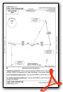
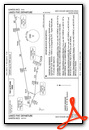
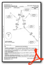
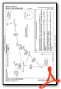
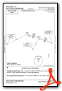
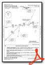
Standard Terminal Arrival (STAR) Charts
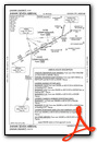
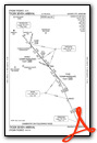
Instrument Approach Procedure (IAP) Charts
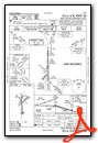
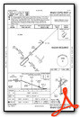
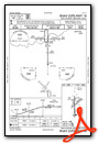
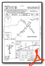
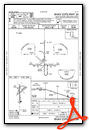
Departure Procedure (DP) Charts
Nearby Airports with Instrument Procedures
| ID | Name | Heading / Distance | ||
|---|---|---|---|---|
 |
KOJC | Johnson County Exec Airport | 082° | 7.2 |
|
K81 | Miami County Airport | 184° | 17.5 |
|
KLWC | Lawrence Regional Airport | 305° | 18.7 |
|
KMKC | Charles B Wheeler Downtown Airport | 038° | 22.4 |
|
KOWI | Ottawa Municipal Airport | 224° | 24.4 |
|
KLXT | Lee's Summit Municipal Airport | 072° | 25.5 |
|
KLRY | Lawrence Smith Memorial Airport | 117° | 28.9 |
|
KMCI | Kansas City International Airport | 016° | 29.2 |
|
KFLV | Sherman AAF Airport | 358° | 32.2 |
|
3GV | East Kansas City Airport | 070° | 33.5 |
|
KFOE | Topeka Regional Airport | 281° | 36.9 |
|
KTOP | Philip Billard Municipal Airport | 292° | 37.1 |
Fuel Providers

Airport Images
Do you have a recent image of this airport? Upload it here!


