Login
Register


K62
Gene Snyder Airport
Official FAA Data Effective 2024-04-18 0901Z
Chart Supplement

VFR Chart of K62
Sectional Charts at SkyVector.com
IFR Chart of K62
Enroute Charts at SkyVector.com
Location Information for K62
Coordinates: N38°42.24' / W84°23.51'Located 04 miles NW of Falmouth, Kentucky on 127 acres of land. View all Airports in Kentucky.
Estimated Elevation is 899 feet MSL.
Operations Data
|
|
Airport Communications
| AWOS-3: | 123.825 Tel. 859-654-1345 |
|---|---|
| CINCINNATI APPROACH: | 121.0 254.25 |
| CINCINNATI DEPARTURE: | 121.0 254.25 |
| UNICOM: | 122.700 |
| HEDEE STAR: | 121.0 254.25 |
| CTAF: | 122.700 |
| CINCE STAR: | 254.25 |
| HARDU STAR: | 119.7 ;090-269 123.875 ;270-089 363.15 |
| SHELBYVILLE STAR: | 119.7 ;090-269 123.875 ;270-089 363.15 |
| ATIS at LUK (24.0 N): | 123.6 |
| AWOS-3 at I69 (24.0 N): | 127.275 513-732-6978 |
| ASOS at LUK (24.2 N): | 513-321-6291 |
Nearby Navigation Aids
|
| ||||||||||||||||||||||||||||||||||||||||||||||||||||||||||||


Runway 03/21
| Dimensions: | 3994 x 75 feet / 1217 x 23 meters | |
|---|---|---|
| Surface: | Asphalt in Good Condition | |
| Weight Limits: | S-12 | |
| Edge Lighting: | Medium Intensity | |
| Runway 03 | Runway 21 | |
| Coordinates: | N38°41.95' / W84°23.69' | N38°42.54' / W84°23.33' |
| Elevation: | 899.2 | 884.7 |
| Runway Heading: | 25° True | 205° True |
| Displaced Threshold: | 100 Feet | |
| Declared Distances: | TORA:3994 TODA:3994 ASDA:3994 LDA:3894 | TORA:3994 TODA:3994 ASDA:3894 LDA:3894 |
| Markings: | Non-Precision Instrument in good condition. | Non-Precision Instrument in good condition. |
| Glide Slope Indicator | P4L (3.50° Glide Path Angle) PAPI UNUSBL BYD 8 DEGS LEFT & 6 DEGS RIGHT OF CNTRLN. | |
| REIL: | Yes | Yes |
| Obstacles: | 65 ft Trees 673 ft from runway, 265 ft right of center | 18 ft Trees 354 ft from runway, 234 ft left of center +8 TREES AT RWY END 155 FT R OF CNTRLN. |
Services Available
| Fuel: | 100LL (blue) |
|---|---|
| Transient Storage: | Tiedowns |
| Airframe Repair: | NOT AVAILABLE |
| Engine Repair: | NOT AVAILABLE |
| Bottled Oxygen: | NOT AVAILABLE |
| Bulk Oxygen: | NOT AVAILABLE |
Ownership Information
| Ownership: | Publicly owned | |
|---|---|---|
| Owner: | DAN BELL, ARPT BOARD CHAIRMAN | |
| 400 GENE SNYDER AIRPORT DRIVE | ||
| FALMOUTH, KY 41040 | ||
| 859-654-1200 | ||
| Manager: | DAN BELL | |
| 400 GENE SNYDER AIRPORT DRIVE | ||
| FALMOUTH, KY 41040 | ||
| 859-654-1200 | ||
Operational Statistics
| Single Engine Aircraft Based on Field: | 12 | Statistics collected for 12 month period ending 2022-06-24 | |
|---|---|---|---|
| Multi-Engine Aircraft Based on Field: | 1 | Annual Commercial Operations: | none |
| Jet Aircraft Based on Field: | none | Annual Commuter Operations: | none |
| Helicopters Based on Field: | 2 | Annual Air Taxi Operations: | 200 |
| Military Aircraft Based on Field: | none | Annual Military Operations: | 150 |
| Gliders Based on Field: | none | Annual GA Local Operations: | 1800 |
| Ultralights Based on Field: | none | Annual GA Itinerant Operations: | 2640 |
Other Remarks
- FOR CD CTC CINCINNATI APCH AT 859-372-6440
- ACTVT REIL RWY 03 & 21; PAPI RWY 03 & 21; MIRL RWY 03/21 - CTAF.
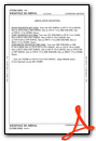
Weather Minimums
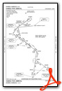
Standard Terminal Arrival (STAR) Charts

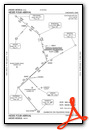
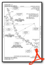
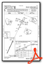
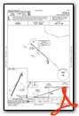
Instrument Approach Procedure (IAP) Charts
Nearby Airports with Instrument Procedures
| ID | Name | Heading / Distance | ||
|---|---|---|---|---|
 |
0I8 | Cynthiana-Harrison County Airport | 165° | 20.9 |
|
KLUK | Cincinnati Municipal/Lunken Field Airport | 357° | 24.0 |
|
I69 | Clermont County Airport | 020° | 24.0 |
|
KCVG | Cincinnati/Northern Kentucky International Airport | 328° | 24.4 |
|
KGEO | Brown County Airport | 065° | 26.2 |
|
27K | Georgetown-Scott County Regional Airport | 184° | 28.2 |
|
KFGX | Fleming-Mason Airport | 107° | 32.0 |
|
I67 | Cincinnati West Airport | 331° | 37.8 |
|
KFFT | Capital City Airport | 217° | 39.6 |
|
KAMT | Alexander Salamon Airport | 076° | 39.7 |
|
KHAO | Butler County Regional/Hogan Field Airport | 351° | 40.0 |
|
KLEX | Blue Grass Airport | 194° | 41.3 |
Airport Images
Do you have a recent image of this airport? Upload it here!


Comments
K62 Fuel is Self Serve. 1/19/2013 $5.31 Per Gal 100LL only
K62 Fuel is Self Serve. There is no FBO
Charlie Pyles
Secretary
K62 Fuel Lowered today
K62 100LL is lowered to $4.25 today.
Charlie Pyles
Secretary