Login
Register


L71
California City Municipal Airport
Official FAA Data Effective 2024-04-18 0901Z
Chart Supplement

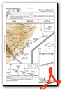
VFR Chart of L71
Sectional Charts at SkyVector.com
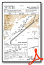
IFR Chart of L71
Enroute Charts at SkyVector.com
Location Information for L71
Coordinates: N35°9.07' / W118°1.00'Located 02 miles NW of California City, California on 245 acres of land. View all Airports in California.
Surveyed Elevation is 2453 feet MSL.
Operations Data
|
|
Airport Communications
| AWOS-1: | 120.875 Tel. 760-373-7670 |
|---|---|
| JOSHUA APPROACH: | 133.65 348.7 |
| JOSHUA DEPARTURE: | 133.65 348.7 |
| CTAF: | 122.700 |
| UNICOM: | 122.700 |
| AWOS-3 at MHV (8.7 SW): | 132.225 661-824-5218 |
| ATIS at EDW (16.0 SE): | 269.9 |
| AWOS-3P at TSP (20.9 W): | 120.025 661-823-0473 |
Nearby Navigation Aids
|
| ||||||||||||||||||||||||||||||||||||||||||


Runway 06/24
| Dimensions: | 6027 x 60 feet / 1837 x 18 meters | |
|---|---|---|
| Surface: | Asphalt in Good Condition | |
| Weight Limits: | S-26 | |
| Edge Lighting: | Medium Intensity | |
| Runway 06 | Runway 24 | |
| Coordinates: | N35°8.95' / W118°1.59' | N35°9.20' / W118°0.41' |
| Elevation: | 2453.5 | 2401.4 |
| Traffic Pattern: | Left | Right |
| Runway Heading: | 76° True | 256° True |
| Markings: | Basic in poor condition. | Basic in poor condition. |
| Glide Slope Indicator | P2L (3.00° Glide Path Angle) | |
| REIL: | Yes | |
Services Available
| Fuel: | 100LL (blue), Jet-A |
|---|---|
| Transient Storage: | Tiedowns |
| Airframe Repair: | MINOR |
| Engine Repair: | MINOR |
| Bottled Oxygen: | LOW |
| Bulk Oxygen: | NOT AVAILABLE |
| Other Services: | GLIDER SERVICE,PILOT INSTRUCTION,PARACHUTE JUMP ACTIVITY,AIRCRAFT RENTAL,GLIDER TOWING SERVICES |
Ownership Information
| Ownership: | Publicly owned | |
|---|---|---|
| Owner: | CITY OF CALIFORNIA CITY | |
| 21000 HACIENDA BLVD | ||
| CALIFORNIA CITY, CA 93505 | ||
| (760) 559-3628 | ||
| Manager: | ROBERT KING | |
| 21000 HACIENDA BOULEVARD | ||
| CALIFORNIA CITY, CA 93505 | ||
| (760) 559-3628 | ||
Operational Statistics
| Single Engine Aircraft Based on Field: | 3 | Statistics collected for 12 month period ending 2023-05-25 | |
|---|---|---|---|
| Multi-Engine Aircraft Based on Field: | none | Annual Commercial Operations: | none |
| Jet Aircraft Based on Field: | 2 | Annual Commuter Operations: | none |
| Helicopters Based on Field: | none | Annual Air Taxi Operations: | none |
| Military Aircraft Based on Field: | none | Annual Military Operations: | 200 |
| Gliders Based on Field: | 3 | Annual GA Local Operations: | 1850 |
| Ultralights Based on Field: | none | Annual GA Itinerant Operations: | 1500 |
Other Remarks
- THIS AIRPORT HAS BEEN SURVEYED BY THE NATIONAL GEODETIC SURVEY.
- RY 06/24 PAEW ADJ RY 0700-1500 DLY.
- FOR CD CTC JOSHUA APCH AT 661-277-3843.
- NO RWY CTRLN. THLD & RWY NR BARELY VSB.
- NO RWY CTRLN. THLD & RWY NR BARELY VSB.
- ACTVT REIL RWY 24, MIRL RWY 06/24 - CTAF. PAPI RWY 24 OPER CONT.
Weather Minimums
Instrument Approach Procedure (IAP) Charts
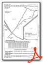
Departure Procedure Obstacles (DPO) Charts
Nearby Airports with Instrument Procedures
| ID | Name | Heading / Distance | ||
|---|---|---|---|---|
 |
KMHV | Mojave Air & Space Port/Rutan Field Airport | 230° | 8.6 |
|
KEDW | Edwards AFB Airport | 156° | 15.9 |
|
KWJF | General Wm J Fox Airfield Airport | 202° | 26.5 |
|
KPMD | Palmdale Usaf Plant 42 Airport | 186° | 31.4 |
|
KIYK | Inyokern Airport | 016° | 31.8 |
|
KVCV | Southern California Logistics Airport | 136° | 45.7 |
|
L45 | Bakersfield Municipal Airport | 282° | 49.2 |
|
KAPV | Apple Valley Airport | 129° | 53.6 |
|
KBFL | Meadows Field Airport | 288° | 53.9 |
|
KWHP | Whiteman Airport | 200° | 56.9 |
|
KBUR | Bob Hope Airport | 196° | 59.4 |
|
KVNY | Van Nuys Airport | 202° | 61.1 |
Airport Images
Do you have a recent image of this airport? Upload it here!


