Login
Register


LAR
Laramie Regional Airport
Official FAA Data Effective 2024-04-18 0901Z
Chart Supplement

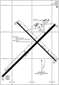
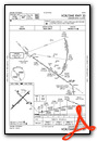
KLAR Airport Diagram
VFR Chart of KLAR
Sectional Charts at SkyVector.com
IFR Chart of KLAR
Enroute Charts at SkyVector.com
Location Information for KLAR
Coordinates: N41°18.72' / W105°40.50'Located 03 miles W of Laramie, Wyoming on 1580 acres of land. View all Airports in Wyoming.
Surveyed Elevation is 7283 feet MSL.
Operations Data
|
|
Airport Communications
| ASOS: | 135.475 Tel. 307-742-6398 |
|---|---|
| CTAF: | 123.050 |
| UNICOM: | 123.050 |
| ASOS at CYS (40.1 E): | 307-632-7680 |
| ATIS at CYS (40.1 E): | 134.425 |
| AWOS-3 at EHY (43.1 NW): | 118.8 307-348-7320 |
- APCH/DEP CTL SVC PRVDD BY DENVER ARTCC (ZDV) ON FREQS 125.9/284.7 (CHEYENNE RCAG).
Nearby Navigation Aids
|
| ||||||||||||||||||||||||||||||||||||||||||||||||||||||


Runway 03/21
| Dimensions: | 8503 x 150 feet / 2592 x 46 meters | |
|---|---|---|
| Surface: | Asphalt / Grooved in Good Condition | |
| Weight Limits: | 50 /F/B/X/T, S-86, D-105, ST-160 | |
| Edge Lighting: | Medium Intensity | |
| Runway 03 | Runway 21 | |
| Coordinates: | N41°18.16' / W105°41.24' | N41°19.14' / W105°39.92' |
| Elevation: | 7283.4 | 7271.6 |
| Traffic Pattern: | Left | Left |
| Runway Heading: | 46° True | 226° True |
| Declared Distances: | TORA:8503 TODA:8503 ASDA:8503 LDA:8503 | TORA:8503 TODA:8503 ASDA:8503 LDA:8503 |
| Markings: | Non-Precision Instrument in good condition. | Non-Precision Instrument in good condition. |
| Glide Slope Indicator | P4L (3.00° Glide Path Angle) | P4L (3.00° Glide Path Angle) |
| REIL: | Yes | Yes |
Runway 12/30
| Dimensions: | 6301 x 100 feet / 1921 x 30 meters | |
|---|---|---|
| Surface: | Asphalt / Grooved in Good Condition | |
| Weight Limits: | S-86, D-105, ST-160 | |
| Edge Lighting: | Medium Intensity | |
| Runway 12 | Runway 30 | |
| Coordinates: | N41°19.18' / W105°40.88' | N41°18.46' / W105°39.90' |
| Elevation: | 7273.4 | 7274.8 |
| Traffic Pattern: | Left | Left |
| Runway Heading: | 135° True | 315° True |
| Declared Distances: | TORA:6301 TODA:6301 ASDA:6301 LDA:6301 | TORA:6301 TODA:6301 ASDA:6301 LDA:6301 |
| Markings: | Non-Precision Instrument in good condition. | Non-Precision Instrument in good condition. |
| Glide Slope Indicator | P4L (3.00° Glide Path Angle) | P4L (3.00° Glide Path Angle) |
| Approach Lights: | ODALS Omnidirectional Approach Lighting System | |
| REIL: | Yes | |
Services Available
| Fuel: | 100LL (blue), Jet-A |
|---|---|
| Transient Storage: | Hangars,Tiedowns |
| Airframe Repair: | NONE |
| Engine Repair: | NONE |
| Bottled Oxygen: | NONE |
| Bulk Oxygen: | NONE |
| Other Services: | AIR FREIGHT SERVICES,CHARTER SERVICE,PILOT INSTRUCTION,AIRCRAFT RENTAL |
Ownership Information
| Ownership: | Publicly owned | |
|---|---|---|
| Owner: | LARAMIE REGIONAL AIRPORT BOARD | |
| 555 GENERAL BREES RD | ||
| LARAMIE, WY 82070 | ||
| 307-742-4164 | ||
| Manager: | AMY TERRELL | |
| 555 GENERAL BREES RD | ||
| LARAMIE, WY 82070 | ||
| 307-742-4164 | ||
Operational Statistics
| Single Engine Aircraft Based on Field: | 29 | Statistics collected for 12 month period ending 2018-12-30 | |
|---|---|---|---|
| Multi-Engine Aircraft Based on Field: | 9 | Annual Commercial Operations: | 36 |
| Jet Aircraft Based on Field: | none | Annual Commuter Operations: | none |
| Helicopters Based on Field: | none | Annual Air Taxi Operations: | 1520 |
| Military Aircraft Based on Field: | none | Annual Military Operations: | 480 |
| Gliders Based on Field: | none | Annual GA Local Operations: | 3190 |
| Ultralights Based on Field: | none | Annual GA Itinerant Operations: | 5260 |
Other Remarks
- AFLD SFC COND UNMNTD 2200-0500.
- FOR CD CTC DENVER ARTCC ON FREQ. IF UNA, CTC FSS ON FREQ VIA RCO. IF UNA, CTC DENVER ARTCC AT 303-651-4257.
- ACTVT ODALS RWY 30; REIL RWY 03, 21 & 12; PAPI RWY 03, 12, 21, & 30; MIRL RWY 03/21 & RWY 12/30 - CTAF.
Weather Minimums
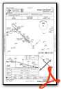
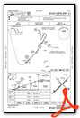
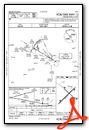
Instrument Approach Procedure (IAP) Charts
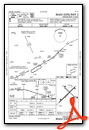
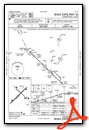
Departure Procedure Obstacles (DPO) Charts
Nearby Airports with Instrument Procedures
| ID | Name | Heading / Distance | ||
|---|---|---|---|---|
 |
KCYS | Cheyenne Regional/Jerry Olson Field Airport | 103° | 40.2 |
|
33V | Walden-Jackson County Airport | 219° | 43.2 |
|
KSAA | Shively Field Airport | 278° | 52.7 |
|
KEAN | Phifer Airfield Airport | 036° | 55.8 |
|
KFNL | Northern Colorado Regional Airport | 149° | 59.8 |
|
KGXY | Greeley-Weld County Airport | 137° | 70.7 |
|
KGUR | Camp Guernsey Airport | 036° | 71.0 |
|
KSBS | Steamboat Springs/Bob Adams Field Airport | 229° | 72.2 |
|
KLMO | Vance Brand Airport | 161° | 72.7 |
|
KGNB | Granby-Grand County Airport | 188° | 74.1 |
|
KRWL | Rawlins Municipal/Harvey Field Airport | 293° | 74.8 |
|
KTOR | Torrington Municipal Airport | 056° | 82.0 |
Airport Images
Do you have a recent image of this airport? Upload it here!


