Login
Register


LEB
Lebanon Municipal Airport
Official FAA Data Effective 2024-04-18 0901Z
Chart Supplement

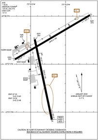
KLEB Airport Diagram
VFR Chart of KLEB
Sectional Charts at SkyVector.com
IFR Chart of KLEB
Enroute Charts at SkyVector.com
Location Information for KLEB
Coordinates: N43°37.57' / W72°18.25'Located 03 miles W of Lebanon, New Hampshire on 563 acres of land. View all Airports in New Hampshire.
Surveyed Elevation is 603 feet MSL.
Operations Data
|
|
Airport Communications
| ATIS: | 118.65 |
|---|---|
| ASOS: | 118.65 Tel. 603-298-8780 |
| LEBANON TOWER: | 125.95 235.775 |
| LEBANON GROUND: | 121.6 |
| UNICOM: | 122.950 |
| CTAF: | 125.950 |
| ASOS at VSF (19.3 SW): | 121.425 802-886-6006 |
| AWOS-3 at 1P1 (25.5 E): | 118.45 603-536-1698 |
| AWOS-3PT at RUT (28.7 W): | 118.375 802-747-3044 |
- APCH/DEP SVC PRVDD BY BOSTON ARTCC ON FREQS 134.7/269.475 (LEBANON RCAG).
Nearby Navigation Aids
|
| ||||||||||||||||||||||||||||||||||||||||||||||||||||||||||||


Runway 07/25
| Dimensions: | 5496 x 100 feet / 1675 x 30 meters | |
|---|---|---|
| Surface: | Asphalt / Grooved in Good Condition | |
| Weight Limits: | S-42, D-60 | |
| Edge Lighting: | Medium Intensity | |
| Runway 07 | Runway 25 | |
| Coordinates: | N43°37.55' / W72°18.72' | N43°38.01' / W72°17.65' |
| Elevation: | 562.5 | 573.8 |
| Traffic Pattern: | Left | Left |
| Runway Heading: | 59° True | 239° True |
| Markings: | Non-Precision Instrument in good condition. | Non-Precision Instrument in good condition. |
| Glide Slope Indicator | P4L (4.00° Glide Path Angle) | P4R (4.00° Glide Path Angle) |
| REIL: | Yes | Yes |
Runway 18/36
| Dimensions: | 5200 x 100 feet / 1585 x 30 meters | |
|---|---|---|
| Surface: | Asphalt / Grooved in Good Condition | |
| Weight Limits: | S-42, D-48 | |
| Edge Lighting: | High Intensity | |
| Runway 18 | Runway 36 | |
| Coordinates: | N43°37.76' / W72°18.44' | N43°36.92' / W72°18.20' |
| Elevation: | 563.5 | 603.3 |
| Traffic Pattern: | Left | Left |
| Runway Heading: | 168° True | 348° True |
| Markings: | Precision Instrument in good condition. | Precision Instrument in good condition. |
| Glide Slope Indicator | P4L (3.75° Glide Path Angle) | |
| REIL: | Yes | |
| Obstacles: | 14 ft Trees 287 ft from runway, 287 ft right of center FENCE 125 FT FM RWY END, 425 FT R. |
TREES 4000 FT W OF EOR, 970 FT MSL, OBST LGTD. TREES 1500 FT SW OF EOR, 800 FT MSL, OBST LGTD. |
Services Available
| Fuel: | 100LL (blue), Jet-A |
|---|---|
| Transient Storage: | Hangars,Tiedowns |
| Airframe Repair: | MAJOR |
| Engine Repair: | MAJOR |
| Bottled Oxygen: | NOT AVAILABLE |
| Bulk Oxygen: | HIGH |
| Other Services: | AIR AMBULANCE SERVICES,CHARTER SERVICE,PILOT INSTRUCTION,ANNUAL SURVEYING |
Ownership Information
| Ownership: | Publicly owned | |
|---|---|---|
| Owner: | CITY OF LEBANON | |
| 51 N PARK ST | ||
| LEBANON, NH 03766 | ||
| 603-298-8878 | ||
| Manager: | CARL GROSS | |
| 5 AIRPARK RD | ||
| WEST LEBANON, NH 03784 | ||
| 603-298-8878 | ||
Operational Statistics
| Single Engine Aircraft Based on Field: | 28 | Statistics collected for 12 month period ending 2018-09-01 | |
|---|---|---|---|
| Multi-Engine Aircraft Based on Field: | 5 | Annual Commercial Operations: | none |
| Jet Aircraft Based on Field: | 3 | Annual Commuter Operations: | none |
| Helicopters Based on Field: | 5 | Annual Air Taxi Operations: | 8034 |
| Military Aircraft Based on Field: | none | Annual Military Operations: | 307 |
| Gliders Based on Field: | none | Annual GA Local Operations: | 7013 |
| Ultralights Based on Field: | none | Annual GA Itinerant Operations: | 10769 |
Other Remarks
- THIS AIRPORT HAS BEEN SURVEYED BY THE NATIONAL GEODETIC SURVEY.
- TREES 5600 FT E OF ARPT, ELEV 1253 FT; TREES 6700 FT E OF ARPT, ELEV 1275 FT; TREES INDCD ARE OBSTN LGTD.
- OCNL WILDLIFE ACT ON & NR ARPT.
- HANG GLDR OPS INVOF MT ASCUTNEY, VT 20 MI SW LEB SFC-8000 FT DAYS.
- NO PLAS OR TGLS 0000-0700.
- NOISE ABATEMENT PROCS IN EFCT, CTC AMGR. ALL ARR/DEP ACFT FLW MANUFACTURER'S RCMDD PROC FOR QUIET OPN & MNM NOISE.
- COLD TEMPERATURE AIRPORT. ALTITUDE CORRECTION REQUIRED AT OR BELOW -20C.
- FOR CD IF TWR CLSD & UNA TO CTC FSS FREQ, CTC BOSTON ARTCC AT 603-879-6859.
- HOT AIR BALLOON ACT 8.6 NM W OF ARPT.
- 0LL FOR FUEL AFT HRS CALL 603-298-6555.
- ACTVT REIL RWY 07 & 25; PAPI RWY 07, 25 & 36; MIRL RWY 07/25; HIRL RWY 18/36 - CTAF.
Weather Minimums
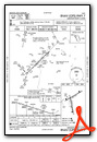
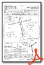
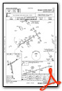
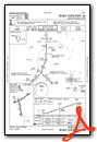
Instrument Approach Procedure (IAP) Charts
Nearby Airports with Instrument Procedures
| ID | Name | Heading / Distance | ||
|---|---|---|---|---|
 |
2B3 | Parlin Field Airport | 160° | 15.2 |
|
KCNH | Claremont Municipal Airport | 190° | 15.6 |
|
KVSF | Hartness State (Springfield) Airport | 208° | 19.3 |
|
KRUT | Rutland/Southern Vermont Regional Airport | 258° | 28.7 |
|
5B9 | Dean Memorial Airport | 025° | 30.1 |
|
KMPV | Edward F Knapp State Airport | 342° | 36.4 |
|
KLCI | Laconia Municipal Airport | 094° | 38.8 |
|
KCON | Concord Municipal Airport | 125° | 43.3 |
|
KEEN | Dillant/Hopkins Airport | 178° | 43.7 |
|
4B6 | Ticonderoga Municipal Airport | 287° | 50.5 |
|
KAFN | Jaffrey Airfield Silver Ranch Airport | 164° | 51.0 |
|
KHIE | Mount Washington Regional Airport | 036° | 55.3 |


