Login
Register


LKV
Lake County Airport
Official FAA Data Effective 2024-04-18 0901Z
Chart Supplement

VFR Chart of KLKV
Sectional Charts at SkyVector.com
IFR Chart of KLKV
Enroute Charts at SkyVector.com
Location Information for KLKV
Coordinates: N42°9.67' / W120°23.94'Located 03 miles SW of Lakeview, Oregon on 1000 acres of land. View all Airports in Oregon.
Surveyed Elevation is 4734 feet MSL.
Operations Data
|
|
Airport Communications
| AWOS-3PT: | 135.525 Tel. 541-947-5069 |
|---|---|
| CTAF: | 122.800 |
| UNICOM: | 122.800 |
| ASOS at AAT (41.3 S): | 124.175 530-233-7171 |
| ASOS at LMT (59.0 W): | 541-883-8127 |
| ATIS at LMT (59.4 W): | 263.0 |
- APCH/DEP CTL SVC PRVDD BY SEATTLE ARTCC (ZSE) ON FREQS 127.6/346.35 (KLAMATH FALLS RCAG).
Nearby Navigation Aids
|
| ||||||||||||||||||||||||||||||


Runway 17/35
| Dimensions: | 5318 x 100 feet / 1621 x 30 meters | |
|---|---|---|
| Surface: | Asphalt in Good Condition | |
| Weight Limits: | S-74, D-86 | |
| Edge Lighting: | Medium Intensity | |
| Runway 17 | Runway 35 | |
| Coordinates: | N42°10.10' / W120°23.94' | N42°9.23' / W120°23.95' |
| Elevation: | 4734.1 | 4725.1 |
| Traffic Pattern: | Left | Left |
| Runway Heading: | 180° True | 0 |
| Markings: | Non-Precision Instrument in good condition. | Non-Precision Instrument in good condition. |
| Glide Slope Indicator | P4R (3.00° Glide Path Angle) | P4L (3.00° Glide Path Angle) |
| REIL: | Yes | Yes |
Services Available
| Fuel: | 100LL (blue), Jet-A |
|---|---|
| Transient Storage: | Tiedowns |
| Airframe Repair: | MAJOR |
| Engine Repair: | MAJOR |
| Bottled Oxygen: | NONE |
| Bulk Oxygen: | NONE |
Ownership Information
| Ownership: | Publicly owned | |
|---|---|---|
| Owner: | LAKE COUNTY | |
| LAKE COUNTY COURTHOUSE, 513 CENTER STREET | ||
| LAKEVIEW, OR 97630 | ||
| 541-947-6003 | ||
| Manager: | TRISTAN WITHAM | |
| 17819 AIRPORT ROAD | ||
| LAKE VIEW, OR 97630 | ||
| 541-947-4222 | ||
Operational Statistics
| Single Engine Aircraft Based on Field: | 15 | Statistics collected for 12 month period ending 2019-06-09 | |
|---|---|---|---|
| Multi-Engine Aircraft Based on Field: | 2 | Annual Commercial Operations: | none |
| Jet Aircraft Based on Field: | none | Annual Commuter Operations: | none |
| Helicopters Based on Field: | none | Annual Air Taxi Operations: | 1200 |
| Military Aircraft Based on Field: | none | Annual Military Operations: | none |
| Gliders Based on Field: | none | Annual GA Local Operations: | 1500 |
| Ultralights Based on Field: | none | Annual GA Itinerant Operations: | 3300 |
Other Remarks
- FLOCKS OF LARGE WATERFOWL IN VICINITY NOV-MAY.
- EXTENSIVE AIRTANKER OPNS IN FIRE SEASON.
- DRAG STRIP ORIENTED NW-SE LOCATED 3000 FT SW OF RY 35.
- POSSIBLE GLIDER OPERATIONS ON TWY.
- TWY NE/SW USED FOR STRONG CROSS WIND LNDG.
- WILDLIFE ON AND INVOF ARPT.
- FOR CD IF UNA TO CTC ON FSS FREQ, CTC SEATTLE ARTCC AT 253-351-3694.
- ACTVT MIRL RWY 17/35, PAPI 17 & 35; REIL RWY 17 & 35 - CTAF.
Weather Minimums
Instrument Approach Procedure (IAP) Charts
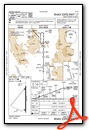
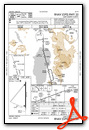
Nearby Airports with Instrument Procedures
| ID | Name | Heading / Distance | ||
|---|---|---|---|---|
 |
KAAT | Alturas Municipal Airport | 190° | 41.4 |
|
KLMT | Crater Lake/Klamath Regional Airport | 270° | 59.5 |
|
62S | Christmas Valley Airport | 349° | 65.6 |
|
O46 | Weed Airport | 246° | 100.8 |
|
KBNO | Burns Municipal Airport | 036° | 106.9 |
|
KSVE | Susanville Municipal Airport | 184° | 107.4 |
|
KMFR | Rogue Valley International - Medford Airport | 277° | 111.0 |
|
S21 | Sunriver Airport | 336° | 112.9 |
|
KBDN | Bend Municipal Airport | 343° | 121.2 |
|
KRDD | Redding Regional Airport | 221° | 130.9 |
|
O85 | Benton Field Airport | 224° | 131.5 |
|
3S8 | Grants Pass Airport | 279° | 134.6 |
Airport Images
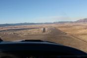
By: skitheo


