Login
Register


LLQ
Monticello Municipal/Ellis Field Airport
Official FAA Data Effective 2024-03-21 0901Z
Chart Supplement

VFR Chart of KLLQ
Sectional Charts at SkyVector.com
IFR Chart of KLLQ
Enroute Charts at SkyVector.com
Location Information for KLLQ
Coordinates: N33°38.31' / W91°45.06'Located 02 miles E of Monticello, Arkansas on 385 acres of land. View all Airports in Arkansas.
Surveyed Elevation is 267 feet MSL.
Operations Data
|
|
Airport Communications
| ASOS: | 133.325 Tel. 870-367-1019 |
|---|---|
| CTAF: | 122.800 |
| UNICOM: | 122.800 |
| ASOS at PBF (33.5 N): | 120.775 870-536-0228 |
| ASOS at GLH (39.4 E): | 125.525 662-332-0863 |
| AWOS-3PT at RNV (50.1 E): | 124.175 662-843-3021 |
- APCH/DEP SVC PRVDD BY MEMPHIS ARTCC ON FREQS 135.875/269.35 (GREENVILLE RCAG & PINE BLUFF RCAG).
Nearby Navigation Aids
|
| ||||||||||||||||||||||||||||||||||||||||||||||||||||||||||||


Runway 03/21
| Dimensions: | 5020 x 75 feet / 1530 x 23 meters | |
|---|---|---|
| Surface: | Asphalt in Good Condition | |
| Weight Limits: | S-17 | |
| Edge Lighting: | Medium Intensity | |
| Runway 03 | Runway 21 | |
| Coordinates: | N33°37.96' / W91°45.32' | N33°38.66' / W91°44.80' |
| Elevation: | 267.4 | 233.8 |
| Traffic Pattern: | Left | Left |
| Runway Heading: | 32° True | 212° True |
| Markings: | Non-Precision Instrument in good condition. | Non-Precision Instrument in good condition. |
| Glide Slope Indicator | P2L (3.00° Glide Path Angle) | P2L (3.00° Glide Path Angle) |
| REIL: | Yes | Yes |
| Obstacles: | 35 ft Power Line 1400 ft from runway | 15 ft Road 540 ft from runway, 150 ft left of center |
Services Available
| Fuel: | 100LL (blue), Jet-A |
|---|---|
| Transient Storage: | Hangars,Tiedowns |
| Airframe Repair: | MINOR |
| Engine Repair: | MINOR |
| Bottled Oxygen: | NONE |
| Bulk Oxygen: | NONE |
| Other Services: | AIR AMBULANCE SERVICES,ANNUAL SURVEYING |
Ownership Information
| Ownership: | Publicly owned | |
|---|---|---|
| Owner: | CITY OF MONTICELLO | |
| PO BOX 505 | ||
| MONTICELLO, AR 71657 | ||
| 870-367-4400 | ||
| Manager: | CARL CHAPPELL | |
| 390 AIRPORT RD. | ||
| MONTICELLO, AR 71655 | ||
| 870-367-4450 | ||
Operational Statistics
| Single Engine Aircraft Based on Field: | 16 | Statistics collected for 12 month period ending 2021-08-31 | |
|---|---|---|---|
| Multi-Engine Aircraft Based on Field: | 3 | Annual Commercial Operations: | none |
| Jet Aircraft Based on Field: | 1 | Annual Commuter Operations: | none |
| Helicopters Based on Field: | 1 | Annual Air Taxi Operations: | none |
| Military Aircraft Based on Field: | none | Annual Military Operations: | 600 |
| Gliders Based on Field: | none | Annual GA Local Operations: | 7200 |
| Ultralights Based on Field: | none | Annual GA Itinerant Operations: | 6000 |
Other Remarks
- FOR CD CTC MEMPHIS ARTCC AT 901-368-8453/8449.
- 0LL SELF SVC FUEL AVBL 24 HRS WITH CREDIT CARD (100LL & JET A)
- ACTVT MIRL RY 03/21, PAPI RYS 03 & 21 & REIL RYS 03 & 21 - CTAF.
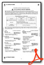
Weather Minimums
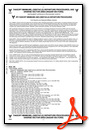
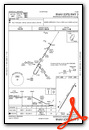
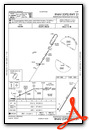
Instrument Approach Procedure (IAP) Charts
Nearby Airports with Instrument Procedures
| ID | Name | Heading / Distance | ||
|---|---|---|---|---|
 |
3M9 | Warren Municipal Airport | 254° | 17.4 |
|
0M0 | Billy Free Municipal Airport | 036° | 18.3 |
|
7M1 | Mc Gehee Municipal Airport | 093° | 19.4 |
|
M32 | Lake Village Municipal Airport | 128° | 28.0 |
|
KCRT | Z M Jack Stell Field Airport | 193° | 28.3 |
|
KPBF | Pinebluff Regional/Grider Field Airport | 344° | 33.4 |
|
KGLH | Greenville Mid-Delta Airport | 103° | 39.5 |
|
5M1 | Dewitt Municipal/Whitcomb Field Airport | 030° | 43.4 |
|
M73 | Almyra Municipal Airport | 017° | 48.5 |
|
KRNV | Cleveland Municipal Airport | 081° | 50.3 |
|
KCDH | Harrell Field Airport | 269° | 50.7 |
|
9M8 | Sheridan-Grant County Regional Airport | 324° | 51.0 |
Airport Images
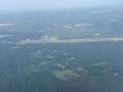
By: Big Orange Bird

By: Airport1228


