Login
Register


LUD
Decatur Municipal Airport
Official FAA Data Effective 2024-04-18 0901Z
Chart Supplement

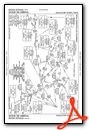
VFR Chart of KLUD
Sectional Charts at SkyVector.com
IFR Chart of KLUD
Enroute Charts at SkyVector.com
Location Information for KLUD
Coordinates: N33°15.25' / W97°34.83'Located 02 miles N of Decatur, Texas on 205 acres of land. View all Airports in Texas.
Surveyed Elevation is 1046 feet MSL.
Operations Data
|
|
Airport Communications
| AWOS-3: | 118.225 Tel. 940-627-2365 |
|---|---|
| REGIONAL APPROACH: | 118.1 306.95 |
| REGIONAL DEPARTURE: | 118.1 306.95 |
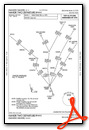
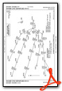
| SASIE STAR: | 124.3 282.275 |
| UNICOM: | 122.800 |
| LIKES STAR: | 125.8 ;SOUTH 135.975 ;NORTH 257.95 |
| TRUUK RNAV STAR: | 118.1 306.95 |
| WESAT STAR: | 118.1 ;SOUTH 125.8 ;NORTH 306.95 |
| GARLAND DP: | 118.1 306.95 |
| DODJE STAR: | 125.2 125.9 343.65 |
| REEKO STAR: | 125.2 343.65 |
| CTAF: | 122.800 |
| MOTZA STAR: | 118.1 ;SOUTH 125.8 ;NORTH 306.95 |
| AWOS-3PT at XBP (13.3 W): | 119.225 940-683-8027 |
| ASOS at DTO (19.3 E): | 119.325 940-383-8457 |
| ATIS at DTO (19.4 E): | 119.325 |
Nearby Navigation Aids
|
| ||||||||||||||||||||||||||||||||||||||||||||||||||||||||||||


Runway 17/35
| Dimensions: | 4200 x 60 feet / 1280 x 18 meters | |
|---|---|---|
| Surface: | Asphalt in Good Condition | |
| Weight Limits: | S-12, D-17 | |
| Edge Lighting: | Medium Intensity | |
| Runway 17 | Runway 35 | |
| Coordinates: | N33°15.60' / W97°34.88' | N33°14.91' / W97°34.78' |
| Elevation: | 1041.2 | 1036.9 |
| Traffic Pattern: | Left | Right |
| Runway Heading: | 172° True | 352° True |
| Markings: | Non-Precision Instrument in fair condition. | Non-Precision Instrument in fair condition. |
| Glide Slope Indicator | P2L (3.50° Glide Path Angle) | P2L (3.50° Glide Path Angle) |
| REIL: | Yes | |
| Obstacles: | 10 ft Tree 243 ft from runway, 125 ft right of center ALSO 30 FT MKD PLINE, 770 FT DSTC, ACRS APCH. 6 FT BRUSH 50 FT FM THR TO 200 FT FM THR, 240-250 FT R. |
15 ft Trees 201 ft from runway, 230 ft right of center 20 FT TREES, 140-199 FT DSTC, 150-250 FT R. |
Services Available
| Fuel: | 100LL (blue), Jet-A |
|---|---|
| Transient Storage: | Hangars,Tiedowns |
| Airframe Repair: | MAJOR |
| Engine Repair: | MAJOR |
| Bottled Oxygen: | NOT AVAILABLE |
| Bulk Oxygen: | NONE |
| Other Services: | PILOT INSTRUCTION,AIRCRAFT RENTAL,AIRCRAFT SALES |
Ownership Information
| Ownership: | Publicly owned | |
|---|---|---|
| Owner: | CITY OF DECATUR | |
| PO BOX 1299 | ||
| DECATUR, TX 76234 | ||
| 940-393-0200 | ||
| Manager: | GREG HALL | |
| 351 AIRPORT ROAD | ||
| DECATUR, TX 76234 | ||
| 940-627-2855 | DIR OF PUBLIC WORKS/AMGR ADDNL PHONE: 940-393-0262. | |
Operational Statistics
| Single Engine Aircraft Based on Field: | 28 | Statistics collected for 12 month period ending 2022-09-19 | |
|---|---|---|---|
| Multi-Engine Aircraft Based on Field: | 3 | Annual Commercial Operations: | none |
| Jet Aircraft Based on Field: | none | Annual Commuter Operations: | none |
| Helicopters Based on Field: | 8 | Annual Air Taxi Operations: | none |
| Military Aircraft Based on Field: | none | Annual Military Operations: | none |
| Gliders Based on Field: | 2 | Annual GA Local Operations: | 9125 |
| Ultralights Based on Field: | none | Annual GA Itinerant Operations: | 27375 |
Other Remarks
- GND DROPS SHARPLY 160 FT NORTH OF RWY 17 THR.
- DEER AND WILDLIFE ON & INVOF ARPT.
- FOR CD CTC REGIONAL APCH AT 972-615-2799.
- DUE TO RWY ELEV CHG, ACFT NOT VSB AT OPPOSITE END.
- DUSK-DAWN. MIRL RWY 17/35 PRESET LOW INTST; TO INCR INTST ACTVT - CTAF.
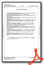
Weather Minimums
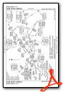
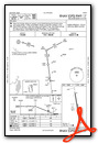
Standard Terminal Arrival (STAR) Charts
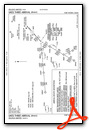
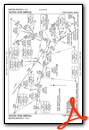
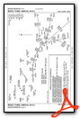
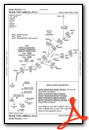
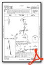
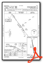
Instrument Approach Procedure (IAP) Charts
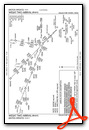
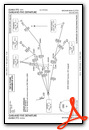
Departure Procedure (DP) Charts
Nearby Airports with Instrument Procedures
| ID | Name | Heading / Distance | ||
|---|---|---|---|---|
 |
KXBP | Bridgeport Municipal Airport | 248° | 13.4 |
|
4T2 | Kenneth Copeland Airport | 164° | 17.2 |
|
KDTO | Denton Enterprise Airport | 099° | 19.4 |
|
KAFW | Perot Field/Fort Worth Alliance Airport | 140° | 20.6 |
|
0F2 | Bowie Municipal Airport | 334° | 23.0 |
|
KFTW | Fort Worth Meacham International Airport | 157° | 28.2 |
|
KNFW | Fort Worth NAS Jrb (Carswell Field) Airport | 166° | 29.9 |
|
KGLE | Gainesville Municipal Airport | 038° | 30.6 |
|
KWEA | Parker County Airport | 189° | 30.9 |
|
KDFW | Dallas-Fort Worth International Airport | 127° | 34.7 |
|
KMWL | Mineral Wells Regional Airport | 220° | 37.2 |
|
50F | Bourland Field Airport | 180° | 40.3 |
Airport Images

By: SamCom


