Login
Register


LYV
Quentin Aanenson Field Airport
Official FAA Data Effective 2024-04-18 0901Z
Chart Supplement

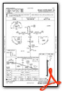
VFR Chart of KLYV
Sectional Charts at SkyVector.com
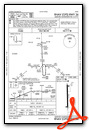
IFR Chart of KLYV
Enroute Charts at SkyVector.com
Location Information for KLYV
Coordinates: N43°37.01' / W96°13.06'Located 02 miles S of Luverne, Minnesota on 85 acres of land. View all Airports in Minnesota.
Surveyed Elevation is 1435 feet MSL.
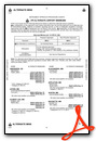
Operations Data
|
|
Airport Communications
| AWOS-3: | 119.825 Tel. 507-283-5027 |
|---|---|
| SIOUX FALLS APPROACH: | 125.8 284.725 |
| SIOUX FALLS DEPARTURE: | 125.8 284.725 |
| CTAF: | 122.700 |
| UNICOM: | 122.700 |
| AWOS-3PT at PQN (22.2 N): | 118.375 507-825-6895 |
| ATIS at FSD (22.9 W): | 126.6 |
| ASOS at FSD (23.4 W): | 605-331-7833 |
- APCH/DEP SVC PRVDD BY MINNEAPOLIS ARTCC ON FREQS 132.05/317.4 (SIOUX FALLS RCAG) WHEN SIOUX FALLS APCH CTL IS CLSD.
Nearby Navigation Aids
|
| ||||||||||||||||||||||||||||||||||||||||||||||||||||||||||||


Runway 18/36
| Dimensions: | 4200 x 75 feet / 1280 x 23 meters | |
|---|---|---|
| Surface: | Asphalt in Fair Condition | |
| Weight Limits: | S-17, D-23 | |
| Edge Lighting: | Medium Intensity | |
| Runway 18 | Runway 36 | |
| Coordinates: | N43°37.35' / W96°13.08' | N43°36.66' / W96°13.05' |
| Elevation: | 1435.0 | 1428.4 |
| Traffic Pattern: | Left | Left |
| Runway Heading: | 178° True | 358° True |
| Markings: | Non-Precision Instrument in good condition. | Non-Precision Instrument in good condition. |
| Glide Slope Indicator | P4L (3.00° Glide Path Angle) | P4L (3.00° Glide Path Angle) |
| REIL: | Yes | Yes |
Services Available
| Fuel: | 100LL (blue), Jet-A |
|---|---|
| Transient Storage: | Tiedowns |
| Airframe Repair: | MAJOR |
| Engine Repair: | MAJOR |
| Bottled Oxygen: | NONE |
| Bulk Oxygen: | NONE |
| Other Services: | CROP DUSTING SERVICES |
Ownership Information
| Ownership: | Publicly owned | |
|---|---|---|
| Owner: | CITY OF LUVERNE | |
| 305 E LUVERNE ST, PO BOX 659 | ||
| LUVERNE, MN 56156-1611 | ||
| 507-449-2388 | ||
| Manager: | BEN BAUM | |
| 941 US HIGHWAY 75, PO BOX 659 | ||
| LUVERNE, MN 56156-4197 | ||
| 507-283-5041 | ARPT FONE. | |
Operational Statistics
| Single Engine Aircraft Based on Field: | 15 | Statistics collected for 12 month period ending 2019-07-31 | |
|---|---|---|---|
| Multi-Engine Aircraft Based on Field: | none | Annual Commercial Operations: | none |
| Jet Aircraft Based on Field: | none | Annual Commuter Operations: | none |
| Helicopters Based on Field: | none | Annual Air Taxi Operations: | none |
| Military Aircraft Based on Field: | none | Annual Military Operations: | none |
| Gliders Based on Field: | none | Annual GA Local Operations: | 3925 |
| Ultralights Based on Field: | none | Annual GA Itinerant Operations: | 4475 |
Other Remarks
- LRG WATERFOWL INVOF ARPT.
- FOR CD CTC SIOUX FALLS APCH AT 605-336-8651, WHEN APCH CLSD CTC MINNEAPOLIS ARTCC AT 651-463-5588.
- 0LL FUEL AVBL H24 SELF SVC VIA CREDIT CARD.
- ACTVT OR INCR INTST REIL RWY 18 & 36; PAPI RWY 18 & 36; MIRL RWY 18/36 - CTAF. RWY LGT PRESET LOW INTST DUSK-DAWN.
Weather Minimums
Instrument Approach Procedure (IAP) Charts
Nearby Airports with Instrument Procedures
| ID | Name | Heading / Distance | ||
|---|---|---|---|---|
 |
KRRQ | Rock Rapids Municipal Airport | 170° | 10.0 |
|
KPQN | Pipestone Municipal Airport | 350° | 22.2 |
|
KFSD | Joe Foss Field Airport | 264° | 22.9 |
|
KISB | Sibley Municipal Airport | 126° | 24.9 |
|
KOTG | Worthington Municipal Airport | 085° | 27.9 |
|
KDVP | Slayton Municipal Airport | 040° | 29.2 |
|
KSHL | Sheldon Regional Airport | 145° | 29.7 |
|
KSXK | Sioux County Regional Airport | 176° | 37.9 |
|
KMDS | Madison Municipal Airport | 302° | 44.7 |
|
KTKC | Tracy Municipal Airport | 034° | 46.3 |
|
KBKX | Brookings Regional Airport | 327° | 48.8 |
|
4D8 | Fuller Airport | 109° | 49.3 |
Airport Images
Do you have a recent image of this airport? Upload it here!


