Login
Register


M18
Hope Municipal Airport
Official FAA Data Effective 2024-04-18 0901Z
Chart Supplement

VFR Chart of M18
Sectional Charts at SkyVector.com
IFR Chart of M18
Enroute Charts at SkyVector.com
Location Information for M18
Coordinates: N33°43.20' / W93°39.53'Located 04 miles NW of Hope, Arkansas on 1575 acres of land. View all Airports in Arkansas.
Surveyed Elevation is 359 feet MSL.
Operations Data
|
|
Airport Communications
| CTAF: | 122.800 |
|---|---|
| UNICOM: | 122.800 |
| ASOS at TXK (22.8 SW): | 120.2 870-774-0404 |
| ATIS at TXK (23.1 SW): | 120.2 |
| AWOS-3 at AGO (37.0 SE): | 118.05 870-901-3532 |
- APCH/DEP CTL SVC PRVDD BY FORT WORTH ARTCC (ZFW) ON FREQS 123.925/269.475 (TEXARKANA RCAG).
Nearby Navigation Aids
|
| ||||||||||||||||||||||||||||||||||||||||||||||||||||||||||||


Runway 16/34
| Dimensions: | 5501 x 100 feet / 1677 x 30 meters | |
|---|---|---|
| Surface: | Concrete in Good Condition | |
| Weight Limits: | S-40, D-55, ST-105 | |
| Edge Lighting: | Medium Intensity NSTD MIRL - LGTS LCTD APRXLY 35 FT FM MARKED RY EDGE. | |
| Runway 16 | Runway 34 | |
| Coordinates: | N33°43.66' / W93°39.41' | N33°42.77' / W93°39.18' |
| Elevation: | 359.2 | 340.4 |
| Traffic Pattern: | Left | Left |
| Runway Heading: | 167° True | 347° True |
| Markings: | Non-Precision Instrument in good condition. | Numbers Only in good condition. |
| Glide Slope Indicator | P2L (3.00° Glide Path Angle) | P2L (3.00° Glide Path Angle) |
| REIL: | Yes | Yes |
| Obstacles: | 32 ft Tree 1300 ft from runway, 330 ft left of center | 29 ft Trees 1200 ft from runway |
Runway 04/22
| Dimensions: | 5301 x 100 feet / 1616 x 30 meters | |
|---|---|---|
| Surface: | Concrete in Fair Condition | |
| Weight Limits: | S-40, D-55, ST-105 | |
| Runway 04 | Runway 22 | |
| Coordinates: | N33°42.89' / W93°40.17' | N33°43.47' / W93°39.40' |
| Elevation: | 330.0 | 351.0 |
| Traffic Pattern: | Left | Left |
| Runway Heading: | 48° True | 228° True |
| Displaced Threshold: | 1190 Feet | 344 Feet |
| Markings: | Non-Precision Instrument in poor condition. | Non-Precision Instrument in poor condition. |
| Obstacles: | 50 ft Trees 250 ft from runway APCH RATIO FROM DSPLCD THR 28:1. |
|
Services Available
| Fuel: | 100LL (blue), Jet-A |
|---|---|
| Transient Storage: | Hangars,Tiedowns |
| Airframe Repair: | NONE |
| Engine Repair: | NONE |
| Bottled Oxygen: | NOT AVAILABLE |
| Bulk Oxygen: | NOT AVAILABLE |
Ownership Information
| Ownership: | Publicly owned | |
|---|---|---|
| Owner: | CITY OF HOPE | |
| PO BOX 667 | ||
| HOPE, AR 71802 | ||
| 870-777-6701 | ||
| Manager: | DARRELL ALLEN | |
| PO BOX 667 | ||
| HOPE, AR 71802 | ||
| 870-777-3444 | ||
Operational Statistics
| Single Engine Aircraft Based on Field: | 17 | Statistics collected for 12 month period ending 2023-11-30 | |
|---|---|---|---|
| Multi-Engine Aircraft Based on Field: | 1 | Annual Commercial Operations: | none |
| Jet Aircraft Based on Field: | none | Annual Commuter Operations: | none |
| Helicopters Based on Field: | none | Annual Air Taxi Operations: | none |
| Military Aircraft Based on Field: | none | Annual Military Operations: | 500 |
| Gliders Based on Field: | none | Annual GA Local Operations: | 2500 |
| Ultralights Based on Field: | none | Annual GA Itinerant Operations: | 5000 |
Other Remarks
- FOR CD CTC FORT WORTH ARTCC AT 817-858-7584.
- DEER ON & INVOF ARPT.
- CNTRLN AND THR MKGS FADED.
- CNTRLN AND THR MKGS FADED.
- CNTRLN AND THR MKGS FADED.
- CNTRLN AND THR MKGS FADED.
- 0LL SELF-SERVE FUEL AVBL 24 HRS (100LL & JET A)
- DUSK-DAWN. REIL & MIRL RY 16/34 OPER DUSK-2200; AFT 2200 ACTVT - CTAF.
Weather Minimums

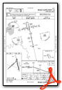
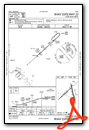
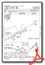
Instrument Approach Procedure (IAP) Charts

Nearby Airports with Instrument Procedures
| ID | Name | Heading / Distance | ||
|---|---|---|---|---|
 |
M77 | Howard County Airport | 331° | 18.9 |
|
KTXK | Texarkana Regional-Webb Field Airport | 226° | 23.1 |
|
KAGO | Ralph C Weiser Field Airport | 142° | 36.9 |
|
KADF | Dexter B Florence Memorial Field Airport | 052° | 37.3 |
|
KDEQ | J Lynn Helms Sevier County Airport | 298° | 41.9 |
|
KCDH | Harrell Field Airport | 097° | 45.2 |
|
KATA | Hall-Miller Municipal Airport | 216° | 45.7 |
|
KSPH | Springhill Airport | 164° | 45.8 |
|
KELD | South Arkansas Regional At Goodwin Field Airport | 124° | 52.0 |
|
KHOT | Memorial Field Airport | 031° | 53.4 |
|
3F4 | Vivian Airport | 199° | 54.4 |
|
KMEZ | Mena Intermountain Municipal Airport | 331° | 56.4 |
Airport Images
Do you have a recent image of this airport? Upload it here!


