Login
Register


M36
Frank Federer Memorial Airport
Official FAA Data Effective 2024-04-18 0901Z
Chart Supplement

VFR Chart of M36
Sectional Charts at SkyVector.com
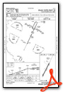
IFR Chart of M36
Enroute Charts at SkyVector.com
Location Information for M36
Coordinates: N34°52.82' / W91°10.59'Located 00 miles SE of Brinkley, Arkansas on 166 acres of land. View all Airports in Arkansas.
Surveyed Elevation is 195 feet MSL.
Operations Data
|
|
Airport Communications
| CTAF: | 122.800 |
|---|---|
| UNICOM: | 122.800 |
| AWOS-3 at DRP (22.6 NE): | 120.0 870-630-8144 |
| AWOS-3PT at SGT (25.8 SW): | 119.025 870-673-1884 |
| AWOS-2 at 4M3 (26.6 W): | 119.275 870-552-1445 |
- APCH/DEP SVC PRVDD BY MEMPHIS ARTCC ON FREQS 135.3/335.8(BRINKLEY RCAG).
Nearby Navigation Aids
|
| ||||||||||||||||||||||||||||||||||||||||||||||||||||||||||||


Runway 02/20
| Dimensions: | 4002 x 75 feet / 1220 x 23 meters | |
|---|---|---|
| Surface: | Asphalt in Good Condition | |
| Weight Limits: | S-12 | |
| Edge Lighting: | Medium Intensity | |
| Runway 02 | Runway 20 | |
| Coordinates: | N34°52.52' / W91°10.76' | N34°53.11' / W91°10.41' |
| Elevation: | 195.1 | 190.6 |
| Traffic Pattern: | Right | Left |
| Runway Heading: | 26° True | 206° True |
| Displaced Threshold: | 248 Feet | 150 Feet |
| Markings: | Non-Precision Instrument in good condition. | Non-Precision Instrument in good condition. |
| Glide Slope Indicator | P2L (3.00° Glide Path Angle) PAPI UNUSBL BYD 5 DEGS LEFT OF CNTRLN. | P2L (3.00° Glide Path Angle) PAPI UNUSBL BYD 4 DEGS LEFT OF CNTRLN AND BYD 7 DEGS RIGHT OF CNTRLN. |
| Obstacles: | 25 ft Pole 525 ft from runway, 200 ft left of center APCH SLOPE 30:1 TO DSPLCD THLD. ROAD & BRIDGE SIGNS AT 180 FT FM THR XNG CNTRLN. |
50 ft Tree 1250 ft from runway, 130 ft right of center APCH SLOPE 32:1 TO DSPLCD THLD. |
Services Available
| Fuel: | 100LL (blue) |
|---|---|
| Transient Storage: | Hangars,Tiedowns |
| Airframe Repair: | MAJOR |
| Engine Repair: | MAJOR |
| Bottled Oxygen: | NOT AVAILABLE |
| Bulk Oxygen: | NOT AVAILABLE |
| Other Services: | CROP DUSTING SERVICES |
Ownership Information
| Ownership: | Publicly owned | |
|---|---|---|
| Owner: | CITY OF BRINKLEY | |
| 233 WEST CEDAR | ||
| BRINKLEY, AR 72021 | ||
| 870-734-1382 | ||
| Manager: | TERRY BURNETT | |
| 233 WEST CEDAR | ||
| BRINKLEY, AR 72021 | ||
| 870-734-5059 | ||
Operational Statistics
| Single Engine Aircraft Based on Field: | 12 | Statistics collected for 12 month period ending 2022-01-31 | |
|---|---|---|---|
| Multi-Engine Aircraft Based on Field: | none | Annual Commercial Operations: | none |
| Jet Aircraft Based on Field: | none | Annual Commuter Operations: | none |
| Helicopters Based on Field: | none | Annual Air Taxi Operations: | none |
| Military Aircraft Based on Field: | none | Annual Military Operations: | 100 |
| Gliders Based on Field: | none | Annual GA Local Operations: | 20000 |
| Ultralights Based on Field: | none | Annual GA Itinerant Operations: | 2000 |
Other Remarks
- WATER-TANK NW.
- NUMEROUS AGRICULTURAL ACFT OPNS FM FEB-NOV 500 FT AGL AND BELOW.
- FOR CD CTC MEMPHIS ARTCC AT 901-368-8453/8449.
- MIGRATORY BIRDS ON & INVOF ARPT
- 0LL FUEL AVBL 24 HRS SELF SVC WITH CREDIT CARD.
- ACTVT MIRL RWY 02/20 - CTAF.
Weather Minimums

Instrument Approach Procedure (IAP) Charts
Nearby Airports with Instrument Procedures
| ID | Name | Heading / Distance | ||
|---|---|---|---|---|
 |
6M7 | Marianna/Lee County-Steve Edwards Field Airport | 107° | 19.0 |
|
KDRP | Delta Regional Airport | 050° | 22.4 |
|
M60 | Woodruff County Airport | 348° | 23.9 |
|
KSGT | Stuttgart Municipal Carl Humphrey Field Airport | 229° | 25.9 |
|
4M3 | Carlisle Municipal Airport | 260° | 26.8 |
|
KHEE | Thompson-Robbins Airport | 126° | 30.7 |
|
M73 | Almyra Municipal Airport | 207° | 31.5 |
|
KSRC | Searcy Regional Airport | 305° | 34.0 |
|
5M1 | Dewitt Municipal/Whitcomb Field Airport | 189° | 37.6 |
|
KUTA | Tunica Municipal Airport | 105° | 42.6 |
|
M19 | Newport Regional Airport | 000° | 45.4 |
|
KLRF | Little Rock AFB Airport | 272° | 47.9 |
Airport Images
Do you have a recent image of this airport? Upload it here!


