Login
Register


M60
Woodruff County Airport
Official FAA Data Effective 2024-04-18 0901Z
Chart Supplement

VFR Chart of M60
Sectional Charts at SkyVector.com
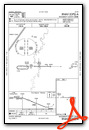
IFR Chart of M60
Enroute Charts at SkyVector.com
Location Information for M60
Coordinates: N35°16.31' / W91°16.22'Located 04 miles E of Augusta, Arkansas on 100 acres of land. View all Airports in Arkansas.
Surveyed Elevation is 200 feet MSL.
Operations Data
|
|
Airport Communications
| CTAF: | 122.900 |
|---|---|
| AWOS-3PT at M19 (22.4 N): | 118.15 870-523-2189 |
| AWOS-3PT at SRC (23.2 W): | 128.325 501-268-4280 |
| AWOS-3 at DRP (23.7 SE): | 120.0 870-630-8144 |
- APCH/DEP SVC PRVDD BY MEMPHIS ARTCC (ZME) ON 135.3/335.8 (BRINKLEY RCAG).
Nearby Navigation Aids
|
| ||||||||||||||||||||||||||||||||||||||||||||||||||||||||||||


Runway 09/27
| Dimensions: | 3797 x 75 feet / 1157 x 23 meters | |
|---|---|---|
| Surface: | Asphalt in Good Condition | |
| Edge Lighting: | Medium Intensity | |
| Runway 09 | Runway 27 | |
| Coordinates: | N35°16.32' / W91°16.60' | N35°16.31' / W91°15.84' |
| Elevation: | 197.8 | 198.1 |
| Markings: | Non-Precision Instrument in good condition. | Non-Precision Instrument in good condition. |
| Glide Slope Indicator | P2L (3.00° Glide Path Angle) | P2L (3.04° Glide Path Angle) |
| Obstacles: | 4 ft Road 300 ft from runway | 30 ft Trees 850 ft from runway, 75 ft right of center |
Services Available
| Fuel: | NONE |
|---|---|
| Transient Storage: | Tiedowns |
| Airframe Repair: | NONE |
| Engine Repair: | NONE |
| Bottled Oxygen: | NOT AVAILABLE |
| Bulk Oxygen: | NOT AVAILABLE |
| Other Services: | CROP DUSTING SERVICES |
Ownership Information
| Ownership: | Publicly owned | |
|---|---|---|
| Owner: | WOODRUFF COUNTY | |
| P.O. BOX 300 | ||
| AUGUSTA, AR 72006 | ||
| 870-347-5206 | ||
| Manager: | MICHAEL-JOHN GRAY - CO. JUDGE | |
| P.O. BOX 300 | ||
| AUGUSTA, AR 72006 | ||
| 870-731-5516 | ||
Operational Statistics
| Single Engine Aircraft Based on Field: | none | Statistics collected for 12 month period ending 2023-02-28 | |
|---|---|---|---|
| Multi-Engine Aircraft Based on Field: | none | Annual Commercial Operations: | none |
| Jet Aircraft Based on Field: | none | Annual Commuter Operations: | none |
| Helicopters Based on Field: | none | Annual Air Taxi Operations: | none |
| Military Aircraft Based on Field: | none | Annual Military Operations: | none |
| Gliders Based on Field: | none | Annual GA Local Operations: | 5000 |
| Ultralights Based on Field: | none | Annual GA Itinerant Operations: | 500 |
Other Remarks
- DEER ON & INVOF ARPT.
- FOR CD CTC MEMPHIS ARTCC AT 901-368-8453/8449.
- ACTVT MIRL RY 09/27 - CTAF.
Weather Minimums

Instrument Approach Procedure (IAP) Charts
Nearby Airports with Instrument Procedures
| ID | Name | Heading / Distance | ||
|---|---|---|---|---|
 |
M19 | Newport Regional Airport | 011° | 22.4 |
|
KSRC | Searcy Regional Airport | 261° | 23.3 |
|
KDRP | Delta Regional Airport | 112° | 23.6 |
|
M36 | Frank Federer Memorial Airport | 168° | 23.9 |
|
KBVX | Batesville Regional Airport | 325° | 32.9 |
|
4M3 | Carlisle Municipal Airport | 218° | 35.3 |
|
6M7 | Marianna/Lee County-Steve Edwards Field Airport | 142° | 37.1 |
|
KHBZ | Heber Springs Municipal Airport | 291° | 39.2 |
|
KSGT | Stuttgart Municipal Carl Humphrey Field Airport | 200° | 43.0 |
|
KJBR | Jonesboro Municipal Airport | 042° | 45.4 |
|
KLRF | Little Rock AFB Airport | 244° | 48.0 |
|
KHEE | Thompson-Robbins Airport | 144° | 50.9 |
Airport Images
Do you have a recent image of this airport? Upload it here!


