Login
Register


M73
Almyra Municipal Airport
Official FAA Data Effective 2024-04-18 0901Z
Chart Supplement

VFR Chart of M73
Sectional Charts at SkyVector.com
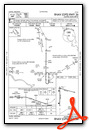
IFR Chart of M73
Enroute Charts at SkyVector.com
Location Information for M73
Coordinates: N34°24.75' / W91°27.92'Located 03 miles W of Almyra, Arkansas on 640 acres of land. View all Airports in Arkansas.
Surveyed Elevation is 210 feet MSL.
Operations Data
|
|
Airport Communications
| LITTLE ROCK APPROACH: | 119.85 353.6 |
|---|---|
| LITTLE ROCK DEPARTURE: | 119.85 353.6 |
| CLEARANCE DELIVERY: | 119.85 |
| UNICOM: | 123.000 |
| CTAF: | 123.000 |
| AWOS-3PT at SGT (12.5 NW): | 119.025 870-673-1884 |
| AWOS-2 at 4M3 (26.4 NW): | 119.275 870-552-1445 |
| ASOS at PBF (27.4 SW): | 120.775 870-536-0228 |
Nearby Navigation Aids
|
| ||||||||||||||||||||||||||||||||||||||||||||||||||||||||||||


Runway 18/36
| Dimensions: | 3494 x 60 feet / 1065 x 18 meters | |
|---|---|---|
| Surface: | Asphalt in Fair Condition | |
| Weight Limits: | S-4 | |
| Edge Lighting: | Medium Intensity | |
| Runway 18 | Runway 36 | |
| Coordinates: | N34°24.94' / W91°28.05' | N34°24.37' / W91°28.05' |
| Elevation: | 208.8 | 203.1 |
| Traffic Pattern: | Left | Left |
| Runway Heading: | 181° True | 1° True |
| Displaced Threshold: | 38 Feet | |
| Markings: | Basic in poor condition. | Non-Precision Instrument in fair condition. |
| Glide Slope Indicator | P2R (3.00° Glide Path Angle) | P2L (3.00° Glide Path Angle) |
| Obstacles: | 15 ft Road 450 ft from runway RWY 18 APCH RATIO FROM DSPLCD THLD 32:1 |
|
Runway 10/28
| Dimensions: | 3000 x 50 feet / 914 x 15 meters | |
|---|---|---|
| Surface: | Asphalt in Fair Condition | |
| Weight Limits: | S-4 | |
| Runway 10 | Runway 28 | |
| Coordinates: | N34°24.93' / W91°28.05' | N34°24.79' / W91°27.48' |
| Elevation: | 208.9 | 204.1 |
| Traffic Pattern: | Left | Left |
| Runway Heading: | 106° True | 286° True |
| Markings: | Basic in fair condition. | Basic in fair condition. |
| Obstacles: | 10 FT GRVL ROAD 0 FT FM THLD. |
20 ft Trees 540 ft from runway, 115 ft right of center |
Services Available
| Fuel: | 100LL (blue) |
|---|---|
| Transient Storage: | Tiedowns |
| Airframe Repair: | MINOR |
| Engine Repair: | MINOR |
| Bottled Oxygen: | NONE |
| Bulk Oxygen: | NONE |
| Other Services: | CROP DUSTING SERVICES |
Ownership Information
| Ownership: | Publicly owned | |
|---|---|---|
| Owner: | CITY OF ALMYRA | |
| P O BOX 213 | ||
| ALMYRA, AR 72003 | ||
| 870-673-1591 | ||
| Manager: | MARK HARTZ | |
| 275 ALMYRA AIRPORT ROAD | ||
| ALMYRA, AR 72003 | ||
| (870) 830-1231 | ||
Operational Statistics
| Single Engine Aircraft Based on Field: | 11 | Statistics collected for 12 month period ending 2022-12-31 | |
|---|---|---|---|
| Multi-Engine Aircraft Based on Field: | none | Annual Commercial Operations: | none |
| Jet Aircraft Based on Field: | none | Annual Commuter Operations: | none |
| Helicopters Based on Field: | none | Annual Air Taxi Operations: | none |
| Military Aircraft Based on Field: | none | Annual Military Operations: | 100 |
| Gliders Based on Field: | none | Annual GA Local Operations: | 50000 |
| Ultralights Based on Field: | none | Annual GA Itinerant Operations: | 4000 |
Other Remarks
- MIGRATORY BIRDS ON & INVOF AIRPORT NOV-FEB
- NUMEROUS AGRICULTURAL ACFT OPNS
- FOR CD WHEN UNA VIA FREQ CTC LITTLE ROCK APCH 501-379-2908 OR LITTLE ROCK ATCT 501-379-2911
- RWY 18 MARKINGS FADED
- 0LL 100 LL SELF SERVE AVBL WITH CREDIT CARD. FOR SVC AFT HRS CALL 870-830-1231.
- ACTVT MIRL RY 18/36, PAPI RYS 18 & 36 - CTAF.
Weather Minimums

Instrument Approach Procedure (IAP) Charts
Nearby Airports with Instrument Procedures
| ID | Name | Heading / Distance | ||
|---|---|---|---|---|
 |
5M1 | Dewitt Municipal/Whitcomb Field Airport | 138° | 11.9 |
|
KSGT | Stuttgart Municipal Carl Humphrey Field Airport | 334° | 12.5 |
|
4M3 | Carlisle Municipal Airport | 332° | 26.7 |
|
KPBF | Pinebluff Regional/Grider Field Airport | 238° | 27.4 |
|
M36 | Frank Federer Memorial Airport | 026° | 31.5 |
|
0M0 | Billy Free Municipal Airport | 186° | 31.8 |
|
6M7 | Marianna/Lee County-Steve Edwards Field Airport | 055° | 39.3 |
|
KHEE | Thompson-Robbins Airport | 075° | 40.4 |
|
KLIT | Bill and Hillary Clinton Ntl/Adams Field Airport | 296° | 42.1 |
|
9M8 | Sheridan-Grant County Regional Airport | 263° | 44.3 |
|
KLRF | Little Rock AFB Airport | 312° | 45.2 |
|
KORK | North Little Rock Municipal Airport | 303° | 46.5 |
Airport Images
Do you have a recent image of this airport? Upload it here!


