Login
Register


M77
Howard County Airport
Official FAA Data Effective 2024-04-18 0901Z
Chart Supplement

VFR Chart of M77
Sectional Charts at SkyVector.com
IFR Chart of M77
Enroute Charts at SkyVector.com
Location Information for M77
Coordinates: N33°59.83' / W93°50.28'Located 03 miles N of Nashville, Arkansas on 85 acres of land. View all Airports in Arkansas.
Surveyed Elevation is 553 feet MSL.
Operations Data
|
|
Airport Communications
| CTAF: | 122.900 |
|---|---|
| ASOS at DEQ (28.1 W): | 134.075 870-642-7829 |
| ASOS at TXK (33.3 S): | 120.2 870-774-0404 |
| ATIS at TXK (33.5 S): | 120.2 |
- APCH/DEP CTL SVC PRVDD BY FORT WORTH ARTCC (ZFW) ON FREQS 123.925/269.475 (TEXARKANA RCAG).
Nearby Navigation Aids
|
| ||||||||||||||||||||||||||||||||||||||||||||||||||||||||||||


Runway 01/19
| Dimensions: | 3994 x 75 feet / 1217 x 23 meters | |
|---|---|---|
| Surface: | Asphalt in Fair Condition | |
| Weight Limits: | S-8 | |
| Edge Lighting: | Medium Intensity | |
| Runway 01 | Runway 19 | |
| Coordinates: | N33°59.51' / W93°50.37' | N34°0.15' / W93°50.20' |
| Elevation: | 528.5 | 549.6 |
| Traffic Pattern: | Left | Left |
| Runway Heading: | 12° True | 192° True |
| Displaced Threshold: | 115 Feet | |
| Markings: | Non-Precision Instrument in poor condition. | Non-Precision Instrument in poor condition. |
| Glide Slope Indicator | P2L (3.00° Glide Path Angle) | P2L (3.00° Glide Path Angle) |
| Obstacles: | 40 ft Trees 1650 ft from runway, 525 ft right of center APCH RATIO 44:1 FM DTHR. +3 FT FENCE 183 FT FROM RWY END. |
15 ft Trees 500 ft from runway, 95 ft left of center |
Services Available
| Fuel: | 100LL (blue) |
|---|---|
| Transient Storage: | Tiedowns |
| Airframe Repair: | NONE |
| Engine Repair: | NONE |
| Bottled Oxygen: | NONE |
| Bulk Oxygen: | NONE |
Ownership Information
| Ownership: | Publicly owned | |
|---|---|---|
| Owner: | HOWARD COUNTY | |
| 421 N. MAIN | ||
| NASHVILLE, AR 71852 | ||
| 870-845-7500 | ||
| Manager: | MARK WILEY | |
| 421 N MAIN | ||
| NASHVILLE, AR 71852 | ||
| 870-904-0733 | ||
Operational Statistics
| Single Engine Aircraft Based on Field: | 6 | Statistics collected for 12 month period ending 2024-01-31 | |
|---|---|---|---|
| Multi-Engine Aircraft Based on Field: | none | Annual Commercial Operations: | none |
| Jet Aircraft Based on Field: | none | Annual Commuter Operations: | none |
| Helicopters Based on Field: | 1 | Annual Air Taxi Operations: | none |
| Military Aircraft Based on Field: | none | Annual Military Operations: | 500 |
| Gliders Based on Field: | none | Annual GA Local Operations: | 3500 |
| Ultralights Based on Field: | none | Annual GA Itinerant Operations: | 2000 |
Other Remarks
- RY 01 FENCE 3 FT AND ROAD 7 FT BELOW THLD 200 FT FM RY END.
- RY 19 TURNAROUND HAS A 10 FT DROP OFF.
- FOR CD CTC FORT WORTH ARTCC AT 817-858-7584.
- MARKINGS FADED RWY 1
- MARKINGS FADED RWY 19
- 0LL SELF SERVE FUEL AVBL 24 HRS.
- ACTVT MIRL RWY 01/19 & PAPI RWYS 01 & 19 - CTAF.
Weather Minimums

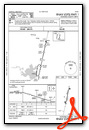
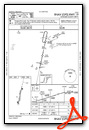
Instrument Approach Procedure (IAP) Charts
Nearby Airports with Instrument Procedures
| ID | Name | Heading / Distance | ||
|---|---|---|---|---|
 |
M18 | Hope Municipal Airport | 151° | 18.9 |
|
KDEQ | J Lynn Helms Sevier County Airport | 276° | 28.1 |
|
KTXK | Texarkana Regional-Webb Field Airport | 193° | 33.4 |
|
KMEZ | Mena Intermountain Municipal Airport | 331° | 37.5 |
|
KADF | Dexter B Florence Memorial Field Airport | 080° | 39.0 |
|
KHOT | Memorial Field Airport | 051° | 46.8 |
|
4O4 | Mc Curtain County Regional Airport | 264° | 51.2 |
|
KAGO | Ralph C Weiser Field Airport | 145° | 55.6 |
|
KATA | Hall-Miller Municipal Airport | 198° | 56.5 |
|
M78 | Malvern Municipal Airport | 069° | 57.3 |
|
KCDH | Harrell Field Airport | 112° | 58.2 |
|
KSPH | Springhill Airport | 160° | 64.4 |
Airport Images
Do you have a recent image of this airport? Upload it here!


