Login
Register


MAE
Madera Municipal Airport
Official FAA Data Effective 2024-04-18 0901Z
Chart Supplement

VFR Chart of KMAE
Sectional Charts at SkyVector.com
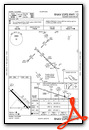
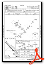
IFR Chart of KMAE
Enroute Charts at SkyVector.com
Location Information for KMAE
Coordinates: N36°59.32' / W120°6.75'Located 03 miles NW of Madera, California on 524 acres of land. View all Airports in California.
Surveyed Elevation is 255 feet MSL.
Operations Data
|
|
Airport Communications
| ASOS: | 134.725 Tel. 559-674-1781 |
|---|---|
| FRESNO APPROACH: | 119.45 |
| FRESNO DEPARTURE: | 119.45 |
| CLEARANCE DELIVERY: | 119.45 |
| UNICOM: | 122.800 |
| CTAF: | 122.800 |
| AWOS-3 at FCH (20.8 SE): | 135.225 559-488-1040 |
| ASOS at FAT (22.6 SE): | 559-255-3413 |
| ATIS at FAT (22.8 SE): | 121.35 |
Nearby Navigation Aids
|
| ||||||||||||||||||||||||||||||||||||||||||


Runway 12/30
OVERRUN 200 FT X 150 FT ASPH RY 12. OVERRUN 200 FT X 150 FT ASPH RY 30. | ||
| Dimensions: | 5545 x 150 feet / 1690 x 46 meters | |
|---|---|---|
| Surface: | Asphalt in Fair Condition | |
| Weight Limits: | S-30 | |
| Edge Lighting: | Medium Intensity | |
| Runway 12 | Runway 30 | |
| Coordinates: | N36°59.64' / W120°7.15' | N36°58.99' / W120°6.34' |
| Elevation: | 249.8 | 255.0 |
| Traffic Pattern: | Right | Left |
| Runway Heading: | 135° True | 315° True |
| Markings: | Non-Precision Instrument in good condition. | Non-Precision Instrument in poor condition. |
| Glide Slope Indicator | P2L (3.00° Glide Path Angle) | P2L (3.00° Glide Path Angle) |
| Approach Lights: | MALSF 1,400 Foot Medium-intensity Approach Lighting System with sequenced flashers. | |
| REIL: | Yes | |
Services Available
| Fuel: | 100LL (blue), Jet-A |
|---|---|
| Transient Storage: | Tiedowns |
| Airframe Repair: | MAJOR |
| Engine Repair: | MAJOR |
| Bottled Oxygen: | HIGH/LOW |
| Bulk Oxygen: | NONE |
| Other Services: | CROP DUSTING SERVICES,AVIONICS,PILOT INSTRUCTION,PARACHUTE JUMP ACTIVITY,AIRCRAFT SALES |
Ownership Information
| Ownership: | Publicly owned | |
|---|---|---|
| Owner: | CITY OF MADERA | |
| 205 WEST 4TH ST | ||
| MADERA, CA 93637 | ||
| (559) 661-5466 | ||
| Manager: | SERGIO MARTINEZ | MCHURCH@CITYOFMADERA.COM |
| 4020 AVIATION DR | ||
| MADERA, CA 93637 | ||
| 559-662-4951 | ||
Operational Statistics
| Single Engine Aircraft Based on Field: | 62 | Statistics collected for 12 month period ending 2020-01-06 | |
|---|---|---|---|
| Multi-Engine Aircraft Based on Field: | 6 | Annual Commercial Operations: | none |
| Jet Aircraft Based on Field: | 6 | Annual Commuter Operations: | none |
| Helicopters Based on Field: | 3 | Annual Air Taxi Operations: | 700 |
| Military Aircraft Based on Field: | none | Annual Military Operations: | 100 |
| Gliders Based on Field: | none | Annual GA Local Operations: | 37870 |
| Ultralights Based on Field: | none ULTRALIGHT ACTIVITY ON AND IN VICINITY OF ARPT; ULTRALIGHT FLY PATTERN 500' AGL NE OF RWY 12/30. |
Annual GA Itinerant Operations: | 12280 |
Other Remarks
- PARACHUTE JUMPING ON ARPT.
- FOR CD CTC FRESNO APCH AT 559-454-9828.
- RUBBER BUILD-UP OBSCS CNTRLN MRKG.
- 0LL FUEL AVBL 24 HRS WITH AUTOMATED CREDIT CARD.
- JET A SINGLE POINT PRESSURE REFUELING AVBL VIA TRUCK.
- ACTVT MIRL RY 12/30; PAPI RYS 12 & 30, REIL RY 12, MALSF RY 30 AND WIND TEE - CTAF.
Weather Minimums
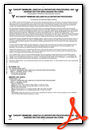
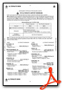
Instrument Approach Procedure (IAP) Charts
Nearby Airports with Instrument Procedures
| ID | Name | Heading / Distance | ||
|---|---|---|---|---|
 |
F34 | Firebaugh Airport | 245° | 18.6 |
|
KFCH | Fresno Chandler Exec Airport | 137° | 20.8 |
|
KFAT | Fresno Yosemite International Airport | 123° | 22.8 |
|
KMCE | Merced Yosemite Regional Airport | 312° | 26.2 |
|
KMPI | Mariposa-Yosemite Airport | 006° | 31.5 |
|
KMER | Castle Airport | 317° | 32.1 |
|
KLSN | Los Banos Municipal Airport | 277° | 36.7 |
|
O32 | Reedley Municipal Airport | 120° | 37.1 |
|
KHJO | Hanford Municipal Airport | 149° | 46.6 |
|
C80 | New Coalinga Municipal Airport | 190° | 50.3 |
|
E45 | Pine Mountain Lake Airport | 356° | 52.4 |
|
KVIS | Visalia Municipal Airport | 138° | 53.1 |
Airport Images
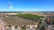
By: LawAviator


