Login
Register


MDD
Midland Airpark Airport
Official FAA Data Effective 2024-04-18 0901Z
Chart Supplement

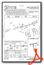
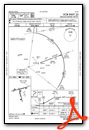
VFR Chart of KMDD
Sectional Charts at SkyVector.com
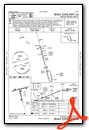
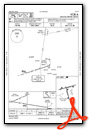
IFR Chart of KMDD
Enroute Charts at SkyVector.com
Location Information for KMDD
Coordinates: N32°2.19' / W102°6.09'Located 03 miles N of Midland, Texas on 816 acres of land. View all Airports in Texas.
Surveyed Elevation is 2805 feet MSL.
Operations Data
|
|
Airport Communications
| AWOS-3: | 118.125 Tel. 432-687-4605 |
|---|---|
| MIDLAND APPROACH: | 124.6 290.4 |
| MIDLAND DEPARTURE: | 124.6 290.4 |
| CLEARANCE DELIVERY: | 121.8 |
| CTAF: | 122.700 |
| UNICOM: | 122.700 |
| ASOS at MAF (7.6 SW): | 432-561-5935 |
| ATIS at MAF (7.6 SW): | 126.8 |
| ASOS at ODO (16.1 SW): | 119.275 432-363-9719 |
- APCH/DEP CTL SVC PRVDD BY FORT WORTH ARTCC (ZFW) ON FREQS 133.1/298.95 (MIDLAND/A RCAG) WHEN MIDLAND APCH CTL (MAF) CLSD.
Nearby Navigation Aids
|
| ||||||||||||||||||||||||||||||||||||||||||||||||||||||


Runway 07/25
| Dimensions: | 5571 x 75 feet / 1698 x 23 meters | |
|---|---|---|
| Surface: | Asphalt / Rubberized Friction Seal Coated in Good Condition | |
| Weight Limits: | S-18 | |
| Edge Lighting: | Medium Intensity | |
| Runway 07 | Runway 25 | |
| Coordinates: | N32°2.22' / W102°6.64' | N32°2.46' / W102°5.59' |
| Elevation: | 2803.4 | 2789.9 |
| Traffic Pattern: | Left | Right |
| Runway Heading: | 75° True | 255° True |
| Displaced Threshold: | 550 Feet | |
| Declared Distances: | TORA:5571 TODA:5571 ASDA:5571 LDA:5022 | |
| Markings: | Basic in good condition. | Non-Precision Instrument in good condition. |
| Glide Slope Indicator | P2L (3.00° Glide Path Angle) | V4L (3.00° Glide Path Angle) |
| Obstacles: | 33 ft Pole 705 ft from runway | 53 ft Pole 2010 ft from runway, 480 ft right of center |
Runway 16/34
| Dimensions: | 3977 x 75 feet / 1212 x 23 meters | |
|---|---|---|
| Surface: | Asphalt in Fair Condition | |
| Weight Limits: | S-18 | |
| Edge Lighting: | Medium Intensity | |
| Runway 16 | Runway 34 | |
| Coordinates: | N32°2.31' / W102°6.16' | N32°1.68' / W102°5.96' |
| Elevation: | 2799.8 | 2796.6 |
| Traffic Pattern: | Left | Right |
| Runway Heading: | 165° True | 345° True |
| Markings: | Basic in good condition. | Non-Precision Instrument in good condition. |
| Glide Slope Indicator | P2L (3.00° Glide Path Angle) | P2L (3.00° Glide Path Angle) |
| Obstacles: | 15 ft Road 495 ft from runway | 38 ft Trees 840 ft from runway, 219 ft right of center |
Services Available
| Fuel: | 100LL (blue), Jet-A |
|---|---|
| Transient Storage: | Hangars,Tiedowns |
| Airframe Repair: | MAJOR |
| Engine Repair: | MAJOR |
| Bottled Oxygen: | HIGH |
| Bulk Oxygen: | HIGH |
| Other Services: | AIR AMBULANCE SERVICES,AVIONICS,CHARTER SERVICE,PILOT INSTRUCTION,AIRCRAFT RENTAL,AIRCRAFT SALES |
Ownership Information
| Ownership: | Publicly owned | |
|---|---|---|
| Owner: | CITY OF MIDLAND | |
| PO BOX 60305 A.T.S. | ||
| MIDLAND, TX 79711 | ||
| 432-560-2200 | ||
| Manager: | JUSTINE RUFF | |
| PO BOX 60305 | ||
| MIDLAND, TX 79711 | ||
| 432-560-2200 | ||
Operational Statistics
| Single Engine Aircraft Based on Field: | 71 | Statistics collected for 12 month period ending 2018-01-04 | |
|---|---|---|---|
| Multi-Engine Aircraft Based on Field: | 7 | Annual Commercial Operations: | none |
| Jet Aircraft Based on Field: | 9 | Annual Commuter Operations: | none |
| Helicopters Based on Field: | 6 | Annual Air Taxi Operations: | 2000 |
| Military Aircraft Based on Field: | none | Annual Military Operations: | 10 |
| Gliders Based on Field: | none | Annual GA Local Operations: | 26000 |
| Ultralights Based on Field: | none | Annual GA Itinerant Operations: | 13000 |
Other Remarks
- THIS AIRPORT HAS BEEN SURVEYED BY THE NATIONAL GEODETIC SURVEY.
- BIRDS INVOF ARPT (SEASONAL).
- FOR CD WHEN 121.8 IS OTS CTC MIDLAND APCH AT 432-563-2123. WHEN APCH CLSD CTC FORT WORTH ARTCC AT 817-858-7584.
- OPRS ON NON-PAVED SURFACES ARE PROHIBITED WITHOUT 24 HR PPR.
- 0LL FOR FUEL AFT HRS, CALL 432-352-9011 DURG BUS HRS TO SCHED APPOINTMENT.
- MIRL RWYS 07/25 & 16/34 PRESET LOW INTST; TO INCR INTST & ACTVT VASI RWY 25; PAPI RWYS 07, 16 & 34 - CTAF.
Weather Minimums
Instrument Approach Procedure (IAP) Charts
Nearby Airports with Instrument Procedures
| ID | Name | Heading / Distance | ||
|---|---|---|---|---|
 |
KMAF | Midland International Air and Space Port Airport | 222° | 7.6 |
|
KODO | Odessa-Schlemeyer Field Airport | 244° | 16.1 |
|
E11 | Andrews County Airport | 309° | 28.0 |
|
KBPG | Big Spring Mc Mahon-Wrinkle Airport | 070° | 31.4 |
|
KLUV | Lamesa Municipal Airport | 012° | 44.1 |
|
KGNC | Gaines County Airport | 323° | 47.4 |
|
E01 | Roy Hurd Memorial Airport | 236° | 49.4 |
|
KINK | Winkler County Airport | 254° | 58.3 |
|
E41 | Reagan County Airport | 147° | 59.6 |
|
KBFE | Terry County Airport | 356° | 68.2 |
|
KHOB | Lea County Regional Airport | 304° | 68.8 |
|
KSNK | Winston Field Airport | 055° | 70.5 |
Airport Images
Do you have a recent image of this airport? Upload it here!


