Login
Register


MFI
Marshfield Municipal Airport
Official FAA Data Effective 2024-04-18 0901Z
Chart Supplement

VFR Chart of KMFI
Sectional Charts at SkyVector.com
IFR Chart of KMFI
Enroute Charts at SkyVector.com
Location Information for KMFI
Coordinates: N44°38.21' / W90°11.36'Located 01 miles S of Marshfield, Wisconsin on 552 acres of land. View all Airports in Wisconsin.
Surveyed Elevation is 1277 feet MSL.
Operations Data
|
|
Airport Communications
| ASOS: | 121.575 Tel. 715-384-3046 |
|---|---|
| CTAF: | 123.000 |
| UNICOM: | 123.000 |
| ASOS at ISW (22.4 SE): | 126.575 715-421-2120 |
| AWOS-3 at CWA (23.9 E): | 127.45 715-693-1116 |
| ATIS at CWA (23.9 E): | 127.45 |
- APCH/DEP SVC PRVDD BY MINNEAPOLIS ARTCC ON FREQS 124.4/317.7 (MOSINEE RCAG).
Nearby Navigation Aids
|
| ||||||||||||||||||||||||||||||||||||||||||||||||||||||||||||


Runway 16/34
| Dimensions: | 5002 x 100 feet / 1525 x 30 meters | |
|---|---|---|
| Surface: | Asphalt in Fair Condition | |
| Weight Limits: | S-35, D-50 | |
| Edge Lighting: | Medium Intensity | |
| Runway 16 | Runway 34 | |
| Coordinates: | N44°38.66' / W90°11.65' | N44°37.89' / W90°11.23' |
| Elevation: | 1277.8 | 1255.4 |
| Traffic Pattern: | Right | Left |
| Runway Heading: | 159° True | 339° True |
| Markings: | Non-Precision Instrument in good condition. | Non-Precision Instrument in good condition. |
| Glide Slope Indicator | V2L (3.00° Glide Path Angle) | V2L (3.00° Glide Path Angle) |
| Approach Lights: | MALSR 1,400 Foot Medium-intensity Approach Lighting System with runway alignment indicator lights. | |
| REIL: | Yes | |
| Obstacles: | 120 ft Trees 2280 ft from runway, 580 ft right of center | 15 ft Trees 230 ft from runway, 480 ft left of center |
Runway 05/23
| Dimensions: | 3597 x 100 feet / 1096 x 30 meters | |
|---|---|---|
| Surface: | Asphalt in Fair Condition | |
| Weight Limits: | S-35, D-45 | |
| Edge Lighting: | Medium Intensity | |
| Runway 05 | Runway 23 | |
| Coordinates: | N44°37.92' / W90°11.55' | N44°38.33' / W90°10.95' |
| Elevation: | 1252.6 | 1249.2 |
| Traffic Pattern: | Right | Left |
| Runway Heading: | 46° True | 227° True |
| Markings: | Non-Precision Instrument in good condition. | Non-Precision Instrument in good condition. |
| Glide Slope Indicator | P2L (3.00° Glide Path Angle) | |
| Obstacles: | 35 ft Trees 500 ft from runway, 200 ft left of center | |
Services Available
| Fuel: | 100LL (blue), Jet A+ |
|---|---|
| Transient Storage: | Hangars,Tiedowns |
| Airframe Repair: | MAJOR |
| Engine Repair: | MINOR |
| Bottled Oxygen: | NONE |
| Bulk Oxygen: | NONE |
| Other Services: | AIR AMBULANCE SERVICES,CHARTER SERVICE,PILOT INSTRUCTION,AIRCRAFT RENTAL |
Ownership Information
| Ownership: | Publicly owned | |
|---|---|---|
| Owner: | CITY OF MARSHFIELD | |
| P.O. BOX 727 | ||
| MARSHFIELD, WI 54449-0727 | ||
| 715-384-2919 | ||
| Manager: | JEFF GAIER | |
| 400 W 29TH ST | ||
| MARSHFIELD, WI 54449 | ||
| 715-387-2211 | ||
Operational Statistics
| Single Engine Aircraft Based on Field: | 11 | Statistics collected for 12 month period ending 2023-08-02 | |
|---|---|---|---|
| Multi-Engine Aircraft Based on Field: | 3 | Annual Commercial Operations: | none |
| Jet Aircraft Based on Field: | 1 | Annual Commuter Operations: | none |
| Helicopters Based on Field: | 1 | Annual Air Taxi Operations: | 2500 |
| Military Aircraft Based on Field: | none | Annual Military Operations: | 150 |
| Gliders Based on Field: | none | Annual GA Local Operations: | 10000 |
| Ultralights Based on Field: | none | Annual GA Itinerant Operations: | 10400 |
Other Remarks
- BIRDS, WATERFOWL & DEER ON & INVOF ARPT.
- RY 34 DEPARTING ACFT CLIMB TO 2000 FT MSL PRIOR TO INITIATING RIGHT TURN.
- FOR CD IF UNA TO CTC ON FSS FREQ, CTC MINNEAPOLIS ARTCC AT 651-463-5588.
- 0LL 24 HR FUEL AVBL WITH CREDIT CARD.
- MIRL RWY 16/34 & RWY 05/23 PRESET TO LOW SS-SR; TO INCR INTST AND ACTVT MALSR RWY 34; REIL RWY 16; VASI RWY 16 & 34; PAPI RWY 05 - CTAF.
Weather Minimums
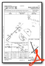
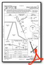
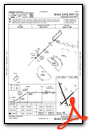
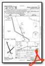
Instrument Approach Procedure (IAP) Charts
Nearby Airports with Instrument Procedures
| ID | Name | Heading / Distance | ||
|---|---|---|---|---|
 |
KVIQ | Neillsville Municipal Airport | 251° | 14.6 |
|
KISW | Alexander Field South Wood County Airport | 137° | 22.4 |
|
KCWA | Central Wisconsin Airport | 069° | 23.9 |
|
KMDZ | Taylor County Airport | 350° | 28.3 |
|
KSTE | Stevens Point Municipal Airport | 100° | 28.8 |
|
KAUW | Wausau Downtown Airport | 053° | 29.6 |
|
KDAF | Necedah Airport | 172° | 36.5 |
|
KBCK | Black River Falls Area Airport | 231° | 36.8 |
|
KRRL | Merrill Municipal Airport | 030° | 39.4 |
|
Y72 | Bloyer Field Airport | 197° | 41.6 |
|
KVOK | Volk Field Airport | 183° | 41.9 |
|
63C | Adams County Legion Field Airport | 156° | 44.1 |
Airport Images
Do you have a recent image of this airport? Upload it here!


