Login
Register


MGG
Maple Lake Municipal-Bill Mavencamp Sr Field Airport
Official FAA Data Effective 2024-03-21 0901Z
Chart Supplement

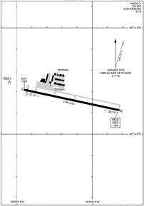
KMGG Airport Diagram
VFR Chart of KMGG
Sectional Charts at SkyVector.com
IFR Chart of KMGG
Enroute Charts at SkyVector.com
Location Information for KMGG
Coordinates: N45°14.16' / W93°59.14'Located 01 miles NE of Maple Lake, Minnesota on 56 acres of land. View all Airports in Minnesota.
Surveyed Elevation is 1028 feet MSL.
Operations Data
|
|
Airport Communications
| AWOS-3: | 128.325 Tel. 320-963-3300 |
|---|---|
| MINNEAPOLIS APPROACH: | 126.5 335.65 |
| MINNEAPOLIS DEPARTURE: | 126.5 335.65 |
| AGUDE STAR: | 335.5 |
| UNICOM: | 122.800 |
| CTAF: | 122.800 |
| AWOS-3PT at CFE (7.7 SE): | 120.45 763-684-0762 |
| ATIS at STC (18.9 N): | 119.375 |
| ASOS at STC (18.9 N): | 125.075 320-240-8781 |
Nearby Navigation Aids
|
| ||||||||||||||||||||||||||||||||||||||||||||||||||||||||||||


Runway 10/28
| Dimensions: | 2796 x 60 feet / 852 x 18 meters | |
|---|---|---|
| Surface: | Asphalt in Fair Condition | |
| Edge Lighting: | Non-Standard NSTD LIRL DUE TO 400 FT SPACING BTN LGTS, 20 FT FM EDGE. | |
| Runway 10 | Runway 28 | |
| Coordinates: | N45°14.21' / W93°59.45' | N45°14.11' / W93°58.82' |
| Elevation: | 1024.0 | 1028.0 |
| Traffic Pattern: | Left | Left |
| Runway Heading: | 102° True | 282° True |
| Displaced Threshold: | 100 Feet | |
| Markings: | Basic in good condition. | Basic in good condition. |
| Obstacles: | 39 ft Power Line 535 ft from runway, 143 ft left of center | 53 ft Trees 791 ft from runway, 126 ft right of center +8 FT RSG TRRN, 170 FT DIST, 80 FT R. |
Services Available
| Fuel: | 100LL (blue) |
|---|---|
| Transient Storage: | Tiedowns |
| Airframe Repair: | NONE |
| Engine Repair: | NONE |
| Bottled Oxygen: | NONE |
| Bulk Oxygen: | NONE |
Ownership Information
| Ownership: | Publicly owned | |
|---|---|---|
| Owner: | CITY OF MAPLE LAKE | |
| PO BOX 757, 10 MAPLE AVE S | ||
| MAPLE LAKE, MN 55358 | ||
| 320-963-3611 | ||
| Manager: | GERALD SAWATZKE | |
| PO BOX 757, 10 MAPLE AVE S | ||
| MAPLE LAKE, MN 55358 | ||
| 320-963-3738 | OR 612-490-8459. | |
Operational Statistics
| Single Engine Aircraft Based on Field: | 43 | Statistics collected for 12 month period ending 2018-07-30 | |
|---|---|---|---|
| Multi-Engine Aircraft Based on Field: | 5 | Annual Commercial Operations: | none |
| Jet Aircraft Based on Field: | none | Annual Commuter Operations: | none |
| Helicopters Based on Field: | none | Annual Air Taxi Operations: | 1000 |
| Military Aircraft Based on Field: | none | Annual Military Operations: | 800 |
| Gliders Based on Field: | none | Annual GA Local Operations: | 15000 |
| Ultralights Based on Field: | 5 | Annual GA Itinerant Operations: | 4000 |
Other Remarks
- THIS AIRPORT HAS BEEN SURVEYED BY THE NATIONAL GEODETIC SURVEY.
- ONE TKOF/LDG PER FLT OPRN, NO TGL OR TRG.
- MIGRATORY WATERFOWL ON & INVOF ARPT.
- FOR CD CTC MINNEAPOLIS APCH AT 612-726-9086.
- 0LL FUEL AVBL H24 SELF SER VIA CREDIT CARD. FUEL GRADE NOT MKD ON PUMP.
Weather Minimums
Standard Terminal Arrival (STAR) Charts
Instrument Approach Procedure (IAP) Charts
Nearby Airports with Instrument Procedures
| ID | Name | Heading / Distance | ||
|---|---|---|---|---|
 |
KCFE | Buffalo Municipal Airport | 127° | 7.6 |
|
KSTC | St Cloud Regional Airport | 350° | 18.9 |
|
KLJF | Litchfield Municipal Airport | 249° | 23.7 |
|
KPNM | Princeton Municipal Airport | 039° | 25.1 |
|
KHCD | Hutchinson Municipal/Butler Field Airport | 216° | 28.2 |
|
KMIC | Crystal Airport | 110° | 28.8 |
|
KGYL | Glencoe Municipal Airport | 188° | 29.1 |
|
KPEX | Paynesville Municipal Airport | 284° | 33.2 |
|
KFCM | Flying Cloud Airport | 137° | 33.2 |
|
KANE | Anoka County/Blaine (Janes Field) Airport | 099° | 33.4 |
|
KCBG | Cambridge Municipal Airport | 057° | 36.1 |
|
KMSP | Minneapolis-St Paul International/Wold-Chamberlain Airport | 122° | 38.8 |
Airport Images
Do you have a recent image of this airport? Upload it here!


