Login
Register


MGY
Dayton/Wright Brothers Airport
Official FAA Data Effective 2024-04-18 0901Z
Chart Supplement

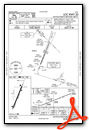
VFR Chart of KMGY
Sectional Charts at SkyVector.com
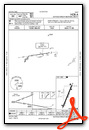
IFR Chart of KMGY
Enroute Charts at SkyVector.com
Location Information for KMGY
Coordinates: N39°35.34' / W84°13.49'Located 10 miles S of Dayton, Ohio on 541 acres of land. View all Airports in Ohio.
Surveyed Elevation is 956 feet MSL.
Operations Data
|
|
Airport Communications
| ASOS: | 118.375 Tel. 937-885-2171 |
|---|---|
| COLUMBUS APPROACH: | 118.85 269.275 |
| COLUMBUS DEPARTURE: | 118.85 269.275 |
| IC: | 269.275 |
| CLEARANCE DELIVERY: | 119.4 |
| CTAF: | 122.800 |
| UNICOM: | 122.800 |
| DANEI STAR: | 134.45 323.15 |
| AWOS-3PT at I68 (7.7 S): | 120.55 513-934-5500 |
| AWOS-3PT at MWO (8.7 SW): | 120.025 513-422-3505 |
| AWOS-3 at GDK (12.6 NE): | 118.525 937-372-4668 |
Nearby Navigation Aids
|
| ||||||||||||||||||||||||||||||||||||||||||||||||||||||||||||


Runway 02/20
| Dimensions: | 5000 x 100 feet / 1524 x 30 meters | |
|---|---|---|
| Surface: | Asphalt / Grooved in Good Condition | |
| Weight Limits: | S-50, D-60 | |
| Edge Lighting: | Medium Intensity | |
| Runway 02 | Runway 20 | |
| Coordinates: | N39°34.96' / W84°13.69' | N39°35.72' / W84°13.29' |
| Elevation: | 936.2 | 956.6 |
| Traffic Pattern: | Left | Left |
| Runway Heading: | 22° True | 202° True |
| Displaced Threshold: | 590 Feet | |
| Declared Distances: | TORA:5000 TODA:5000 ASDA:4700 LDA:4700 | TORA:5000 TODA:5000 ASDA:5000 LDA:4410 |
| Markings: | Non-Precision Instrument in fair condition. | Non-Precision Instrument in fair condition. |
| Glide Slope Indicator | P2L (3.00° Glide Path Angle) | P4L (3.00° Glide Path Angle) PAPI UNUSBL BYD 7 DEGS RIGHT OF CNTRLN. |
| Approach Lights: | MALS 1,400 Foot Medium-intensity Approach Lighting System. | |
| Obstacles: | 25 ft Road 540 ft from runway, 300 ft right of center APCH SLP 34:1 TO DTHR. |
|
Services Available
| Fuel: | 100LL (blue), Jet-A, Jet A+ |
|---|---|
| Transient Storage: | Hangars,Tiedowns PRIOR CDN RQRD. |
| Airframe Repair: | MAJOR |
| Engine Repair: | MAJOR |
| Bottled Oxygen: | HIGH/LOW |
| Bulk Oxygen: | NONE |
| Other Services: | AIR FREIGHT SERVICES,CARGO HANDLING SERVICES,CHARTER SERVICE,PILOT INSTRUCTION,AIRCRAFT RENTAL,AIRCRAFT SALES |
Ownership Information
| Ownership: | Publicly owned | |
|---|---|---|
| Owner: | CITY OF DAYTON | |
| 3600 TERMINAL DR STE 300 | ||
| VANDALIA, OH 45377-1095 | ||
| 937-885-4121 | ||
| Manager: | BRANDON ELLIS | |
| 10550 N SPRINGBORO PIKE | ||
| MIAMISBURG, OH 45342-4956 | ||
| 937-454-8230 | CELL 937-776-2194. | |
Operational Statistics
| Single Engine Aircraft Based on Field: | 60 | Statistics collected for 12 month period ending 2022-09-08 | |
|---|---|---|---|
| Multi-Engine Aircraft Based on Field: | 10 | Annual Commercial Operations: | none |
| Jet Aircraft Based on Field: | 7 | Annual Commuter Operations: | none |
| Helicopters Based on Field: | 5 | Annual Air Taxi Operations: | 937 |
| Military Aircraft Based on Field: | none | Annual Military Operations: | 21 |
| Gliders Based on Field: | none | Annual GA Local Operations: | 27008 |
| Ultralights Based on Field: | none | Annual GA Itinerant Operations: | 10885 |
Other Remarks
- THIS AIRPORT HAS BEEN SURVEYED BY THE NATIONAL GEODETIC SURVEY.
- DEER, BIRDS, & OTR WILDLIFE ON & INVOF ARPT.
- SFC CONDS UNMON 1530-0700 WKDAYS & ALL DAY WKENDS/HOLS.
- FULL PWR MAINT RUNUPS PROHIBITED IN THE HLDG APN AT THE NW CORNER OF TWY A 0800-1700 WKDAYS.
- ACTVT MALS RWY 20; PAPI RWY 02 & 20; MIRL RWY 02/20 - CTAF. TWY LGTS OPR CONSLY SS-SR.
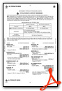
Weather Minimums

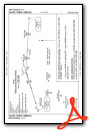
Standard Terminal Arrival (STAR) Charts
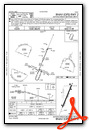
Instrument Approach Procedure (IAP) Charts
Nearby Airports with Instrument Procedures
| ID | Name | Heading / Distance | ||
|---|---|---|---|---|
 |
I73 | Moraine Air Park Airport | 352° | 5.6 |
|
I68 | Warren County/John Lane Field Airport | 189° | 7.7 |
|
KMWO | Middletown Regional/Hook Field Airport | 246° | 8.7 |
|
KGDK | Greene County/Lewis A Jackson Regional Airport | 060° | 12.4 |
|
KFFO | Wright-Patterson AFB Airport | 030° | 16.4 |
|
I66 | Clinton Field Airport | 107° | 17.6 |
|
KDAY | James M Cox Dayton International Airport | 000° | 18.8 |
|
KHAO | Butler County Regional/Hogan Field Airport | 225° | 19.3 |
|
3I7 | Dayton/Phillipsburg Airport | 337° | 21.1 |
|
KILN | Wilmington Air Park Airport | 115° | 22.3 |
|
KSGH | Springfield/Beckley Municipal Airport | 049° | 23.3 |
|
KOXD | Miami University Airport | 258° | 26.5 |
Airport Images
Do you have a recent image of this airport? Upload it here!


