Login
Register


MHE
Mitchell Municipal Airport
Official FAA Data Effective 2024-04-18 0901Z
Chart Supplement

VFR Chart of KMHE
Sectional Charts at SkyVector.com
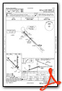
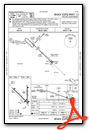
IFR Chart of KMHE
Enroute Charts at SkyVector.com
Location Information for KMHE
Coordinates: N43°46.49' / W98°2.32'Located 03 miles N of Mitchell, South Dakota on 1376 acres of land. View all Airports in South Dakota.
Surveyed Elevation is 1304 feet MSL.
Operations Data
|
|
Airport Communications
| ASOS: | 124.175 Tel. 605-995-5803 |
|---|---|
| UNICOM: | 122.800 |
| CTAF: | 122.800 |
| ASOS at HON (37.6 N): | 118.125 605-352-7531 |
| AWOS-3 at MDS (43.7 E): | 118.35 605-427-9380 |
| AWOS-3P at 6E5 (44.6 NE): | 118.150 605-860-2233 |
- COMMUNICATIONS PRVDD BY HURON RADIO FREQ 122.3 (MITCHELL RCO).
- APCH/DEP SVC PRVDD BY MINNEAPOLIS ARTCC (ZMP) ON FREQ 126.25/339.8 (HURON RCAG).
Nearby Navigation Aids
|
| ||||||||||||||||||||||||||||||||||||||||||||||||||||||||||||


Runway 13/31
| Dimensions: | 6701 x 100 feet / 2042 x 30 meters | |
|---|---|---|
| Surface: | Asphalt in Good Condition | |
| Weight Limits: | S-55, D-90, ST-120 | |
| Edge Lighting: | High Intensity | |
| Runway 13 | Runway 31 | |
| Coordinates: | N43°46.86' / W98°3.09' | N43°46.09' / W98°2.00' |
| Elevation: | 1296.1 | 1303.6 |
| Traffic Pattern: | Left | Left |
| Runway Heading: | 134° True | 314° True |
| Markings: | Precision Instrument in good condition. | Precision Instrument in good condition. |
| Glide Slope Indicator | P4L (3.00° Glide Path Angle) | P4L (3.00° Glide Path Angle) |
| Approach Lights: | MALSR 1,400 Foot Medium-intensity Approach Lighting System with runway alignment indicator lights. | |
| REIL: | Yes | |
Runway 18/36
| Dimensions: | 5513 x 100 feet / 1680 x 30 meters | |
|---|---|---|
| Surface: | Asphalt / Porous Friction Course in Fair Condition | |
| Weight Limits: | S-35, D-90, ST-110 | |
| Edge Lighting: | Medium Intensity | |
| Runway 18 | Runway 36 | |
| Coordinates: | N43°46.97' / W98°2.04' | N43°46.06' / W98°2.03' |
| Elevation: | 1282.8 | 1303.0 |
| Traffic Pattern: | Left | Left |
| Runway Heading: | 180° True | 360° True |
| Markings: | Non-Precision Instrument in fair condition. | Non-Precision Instrument in fair condition. |
| Glide Slope Indicator | P4L (3.00° Glide Path Angle) | P4L (3.00° Glide Path Angle) |
| REIL: | Yes | |
Services Available
| Fuel: | 100LL (blue), Jet-A |
|---|---|
| Transient Storage: | Hangars,Tiedowns |
| Airframe Repair: | MAJOR |
| Engine Repair: | MAJOR |
| Bottled Oxygen: | NONE |
| Bulk Oxygen: | NONE |
| Other Services: | AIR FREIGHT SERVICES,CROP DUSTING SERVICES,CHARTER SERVICE,PILOT INSTRUCTION,AIRCRAFT RENTAL,AIRCRAFT SALES |
Ownership Information
| Ownership: | Publicly owned | |
|---|---|---|
| Owner: | CITY OF MITCHELL | |
| 612 N MAIN ST. | ||
| MITCHELL, SD 57301 | ||
| 605-995-8420 | ||
| Manager: | MIKE SCHERSCHLIGT | |
| 621 WEST 5TH | ||
| MITCHELL, SD 57301 | ||
| 605-770-4594 | ||
Operational Statistics
| Single Engine Aircraft Based on Field: | 24 | Statistics collected for 12 month period ending 2023-09-27 | |
|---|---|---|---|
| Multi-Engine Aircraft Based on Field: | 3 | Annual Commercial Operations: | none |
| Jet Aircraft Based on Field: | 2 | Annual Commuter Operations: | none |
| Helicopters Based on Field: | 2 | Annual Air Taxi Operations: | 580 |
| Military Aircraft Based on Field: | none | Annual Military Operations: | 60 |
| Gliders Based on Field: | none | Annual GA Local Operations: | 9100 |
| Ultralights Based on Field: | none | Annual GA Itinerant Operations: | 5200 |
Other Remarks
- MIGRATORY BIRDS ON & INVOF ARPT.
- ULTRALGT ACTVT ON & INVOF ARPT.
- FOR CD IF UNA TO CTC ON FSS FREQ, CTC MINNEAPOLIS ARTCC AT 651-463-5588.
- 0LL FUEL AVBL 24 HRS A DAY.
- ACTVT MALSR RWY 31, REIL RWY 13 & 18, PAPI RWY 13, 31, 18 & 36 , HIRL RWY 13/31; MIRL RWY 18/36 - CTAF.
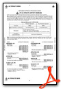
Weather Minimums
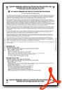
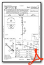
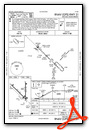
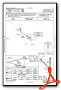
Instrument Approach Procedure (IAP) Charts

Nearby Airports with Instrument Procedures
| ID | Name | Heading / Distance | ||
|---|---|---|---|---|
 |
8V3 | Parkston Municipal Airport | 174° | 23.9 |
|
4X4 | Wessington Springs Airport | 308° | 27.5 |
|
KHON | Huron Regional Airport | 347° | 37.5 |
|
KMDS | Madison Municipal Airport | 070° | 43.8 |
|
KAGZ | Wagner Municipal Airport | 194° | 44.1 |
|
9V9 | Chamberlain Municipal Airport | 269° | 55.8 |
|
KFSD | Joe Foss Field Airport | 101° | 57.6 |
|
KYKN | Chan Gurney Municipal Airport | 150° | 58.9 |
|
KMKA | Miller Municipal Airport | 318° | 60.0 |
|
KBKX | Brookings Regional Airport | 058° | 61.6 |
|
9D1 | Gregory Municipal - Flynn Field Airport | 241° | 68.2 |
|
8D7 | Clark County Airport | 011° | 68.7 |
Airport Images
Do you have a recent image of this airport? Upload it here!


