Login
Register


MIT
Shafter-Minter Field Airport
Official FAA Data Effective 2024-04-18 0901Z
Chart Supplement

VFR Chart of KMIT
Sectional Charts at SkyVector.com
IFR Chart of KMIT
Enroute Charts at SkyVector.com
Location Information for KMIT
Coordinates: N35°30.45' / W119°11.53'Located 04 miles E of Shafter, California on 1206 acres of land. View all Airports in California.
Surveyed Elevation is 424 feet MSL.
Operations Data
|
|
Airport Communications
| AWOS-3: | 121.125 Tel. 661-393-8596 |
|---|---|
| BAKERSFIELD APPROACH: | 126.45 270.3 |
| BAKERSFIELD DEPARTURE: | 126.45 270.3 |
| CTAF: | 122.900 |
| ATIS at BFL (7.9 SE): | 118.6 |
| ASOS at BFL (8.0 SE): | 661-393-3766 |
| AWOS-3P at DLO (14.4 N): | 119.55 661-721-2668 |
- APCH/DEP CTL SVC PRVDD BY LOS ANGELES ARTCC (ZLA) ON FREQS 127.1/317.7 (BAKERSFIELD RCAG) WHEN BAKERSFIELD APCH CTL (BFL) CLSD.
Nearby Navigation Aids
|
| ||||||||||||||||||||||||||||||||||||||||||||||||


Runway 12/30
| Dimensions: | 4501 x 100 feet / 1372 x 30 meters | |
|---|---|---|
| Surface: | Asphalt in Good Condition | |
| Weight Limits: | S-22 | |
| Edge Lighting: | Medium Intensity | |
| Runway 12 | Runway 30 | |
| Coordinates: | N35°30.64' / W119°12.06' | N35°30.13' / W119°11.40' |
| Elevation: | 412.5 | 412.2 |
| Traffic Pattern: | Right | Left |
| Runway Heading: | 133° True | 313° True |
| Markings: | Non-Precision Instrument in good condition. | Non-Precision Instrument in good condition. |
| Glide Slope Indicator | P4L (3.00° Glide Path Angle) | |
| REIL: | Yes | Yes |
Runway 08/26
| Dimensions: | 3680 x 60 feet / 1122 x 18 meters | |
|---|---|---|
| Surface: | Asphalt in Good Condition | |
| Weight Limits: | S-125 | |
| Runway 08 | Runway 26 | |
| Coordinates: | N35°30.63' / W119°11.95' | N35°30.63' / W119°11.21' |
| Elevation: | 413.7 | 424.6 |
| Traffic Pattern: | Right | |
| Runway Heading: | 90° True | 270° True |
| Displaced Threshold: | 140 Feet | 166 Feet |
| Markings: | Basic in good condition. | Basic in good condition. |
| Obstacles: | 60 ft Trees 1896 ft from runway, 190 ft right of center 33:1 TO DSPLCD THLD. |
20 ft Building 411 ft from runway 28:1 TO THE DSPLCD THLD. |
Runway 17/35
| Dimensions: | 2972 x 100 feet / 906 x 30 meters | |
|---|---|---|
| Surface: | Concrete in Good Condition | |
| Weight Limits: | S-25, D-30 | |
| Runway 17 | Runway 35 | |
| Coordinates: | N35°30.56' / W119°11.16' | N35°30.07' / W119°11.16' |
| Elevation: | 423.1 | 414.3 |
| Traffic Pattern: | Right | Left |
| Runway Heading: | 180° True | 0 |
| Markings: | Basic in good condition. | Basic in good condition. |
| Obstacles: | 15 ft Road 850 ft from runway, 190 ft left of center | 15 ft Road 470 ft from runway |
Services Available
| Fuel: | 100LL (blue), Jet-A |
|---|---|
| Transient Storage: | Tiedowns |
| Airframe Repair: | MAJOR |
| Engine Repair: | MAJOR |
| Bottled Oxygen: | NONE |
| Bulk Oxygen: | NONE |
| Other Services: | CROP DUSTING SERVICES,PILOT INSTRUCTION |
Ownership Information
| Ownership: | Publicly owned | |
|---|---|---|
| Owner: | MINTER FIELD AIRPORT DISTRICT | |
| 201 AVIATION ST | ||
| SHAFTER, CA 93263 | ||
| 661-393-0402 | AFTER HOURS 661-303-6996 | |
| Manager: | JONATHAN HUDSON | |
| 201 AVIATION ST | ||
| SHAFTER, CA 93263 | ||
| (661) 303-6996 | ||
Operational Statistics
| Single Engine Aircraft Based on Field: | 91 | Statistics collected for 12 month period ending 2023-12-05 | |
|---|---|---|---|
| Multi-Engine Aircraft Based on Field: | 7 | Annual Commercial Operations: | none |
| Jet Aircraft Based on Field: | 7 | Annual Commuter Operations: | none |
| Helicopters Based on Field: | 2 | Annual Air Taxi Operations: | none |
| Military Aircraft Based on Field: | none | Annual Military Operations: | none |
| Gliders Based on Field: | 1 | Annual GA Local Operations: | 20000 |
| Ultralights Based on Field: | none | Annual GA Itinerant Operations: | 25000 |
Other Remarks
- HEAVY CROP DUSTER ACTIVITY INVOF ARPT.
- FUEL 24 HR CREDIT CARD SVC AVBL.
- ULTRALIGHT ACTIVITY ON & INVOF ARPT.
- RY 30 PREFERRED CALM WIND RY.
- RYS 26 AND 08 USED EXTENSIVELY BY AERIAL APPLICATOR ACFT. RECOMMEND EXTENSIVE USAGE OF CTAF FOR POSITION REPORTING.
- FOR CD CTC LOS ANGELES ARTCC AT 661-575-2079.
- ACTVT REIL RWY 12 & 30; PAPI RWY 30; MIRL RWY 12/30 - CTAF.
Weather Minimums
Instrument Approach Procedure (IAP) Charts
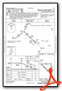
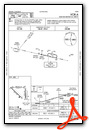
Nearby Airports with Instrument Procedures
| ID | Name | Heading / Distance | ||
|---|---|---|---|---|
 |
KBFL | Meadows Field Airport | 123° | 7.9 |
|
KDLO | Delano Municipal Airport | 351° | 14.4 |
|
L45 | Bakersfield Municipal Airport | 138° | 14.6 |
|
KPTV | Porterville Municipal Airport | 011° | 31.9 |
|
KTLR | Mefford Field Airport | 350° | 39.4 |
|
KVIS | Visalia Municipal Airport | 348° | 49.6 |
|
KHJO | Hanford Municipal Airport | 336° | 52.9 |
|
KMHV | Mojave Air & Space Port/Rutan Field Airport | 117° | 57.8 |
|
L71 | California City Municipal Airport | 109° | 61.5 |
|
KWJF | General Wm J Fox Airfield Airport | 133° | 66.4 |
|
C80 | New Coalinga Municipal Airport | 306° | 66.6 |
|
KIYK | Inyokern Airport | 081° | 67.3 |


