Login
Register


MLT
Millinocket Municipal Airport
Official FAA Data Effective 2024-04-18 0901Z
Chart Supplement

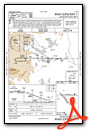
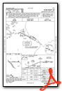
VFR Chart of KMLT
Sectional Charts at SkyVector.com
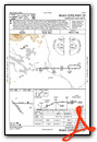
IFR Chart of KMLT
Enroute Charts at SkyVector.com
Location Information for KMLT
Coordinates: N45°38.87' / W68°41.13'Located 01 miles SE of Millinocket, Maine on 322 acres of land. View all Airports in Maine.
Surveyed Elevation is 408 feet MSL.
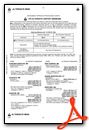
Operations Data
|
|
Airport Communications
| ASOS: | 135.225 Tel. 207-723-8396 |
|---|---|
| UNICOM: | 122.800 |
| CTAF: | 122.800 |
| AWOS-A at 3B1 (38.2 W): | 124.175 207-695-2581 |
| ASOS at HUL (46.8 NE): | 132.025 207-532-1584 |
| ASOS at BGR (50.8 S): | 127.75 207-561-2515 |
- APCH/DEP SVC PRVDD BY BOSTON ARTCC ON FREQS 120.25/346.4 (BANGOR RCAG).
Nearby Navigation Aids
|
| ||||||||||||||||||||||||||||||||||||||||||||||||


Runway 11/29
| Dimensions: | 4713 x 99 feet / 1437 x 30 meters | |
|---|---|---|
| Surface: | Asphalt in Fair Condition | |
| Weight Limits: | S-30, D-44 | |
| Edge Lighting: | Medium Intensity | |
| Runway 11 | Runway 29 | |
| Coordinates: | N45°38.96' / W68°41.57' | N45°38.96' / W68°40.46' |
| Elevation: | 400.9 | 395.1 |
| Traffic Pattern: | Left | Left |
| Runway Heading: | 90° True | 270° True |
| Markings: | Non-Precision Instrument in poor condition. | Non-Precision Instrument in poor condition. |
| Glide Slope Indicator | V4R (3.00° Glide Path Angle) | |
| REIL: | Yes | |
| Obstacles: | 27 ft Building 465 ft from runway, 240 ft right of center | 16 ft Trees 451 ft from runway, 35 ft left of center SCRUB TREES 80 FT FM END OF RWY, 144 FT L. |
Runway 16/34
| Dimensions: | 4000 x 100 feet / 1219 x 30 meters | |
|---|---|---|
| Surface: | Asphalt in Fair Condition | |
| Weight Limits: | S-30, D-44 | |
| Runway 16 | Runway 34 | |
| Coordinates: | N45°39.01' / W68°41.58' | N45°38.52' / W68°40.96' |
| Elevation: | 400.3 | 379.9 |
| Traffic Pattern: | Left | Left |
| Runway Heading: | 139° True | 319° True |
| Markings: | Basic in poor condition. | Basic in poor condition. |
| Obstacles: | 62 ft Trees 1180 ft from runway, 45 ft right of center | 15 ft Road 255 ft from runway, 130 ft left of center |
Services Available
| Fuel: | 100LL (blue), Jet-A |
|---|---|
| Transient Storage: | Hangars,Tiedowns CALL 207-723-6649 FOR AVBL. |
| Airframe Repair: | NONE |
| Engine Repair: | NONE |
| Bottled Oxygen: | NONE |
| Bulk Oxygen: | NONE |
| Other Services: | PILOT INSTRUCTION,PARACHUTE JUMP ACTIVITY PAJA TO 10500 FT 0700 - SS DLY. |
Ownership Information
| Ownership: | Publicly owned | |
|---|---|---|
| Owner: | TOWN OF MILLINOCKET | |
| 197 PENOBSCOT AVE | ||
| MILLINOCKET, ME 04462 | ||
| 207-723-6649 | ||
| Manager: | TOWN OF MILLINOCKET | |
| MILLINOCKET MUNICIPAL ARPT.,, 16 MEDWAY RD. | ||
| MILLINOCKET, ME 04462 | ||
| 207-723-6649 | ||
Operational Statistics
| Single Engine Aircraft Based on Field: | 16 | Statistics collected for 12 month period ending 2020-08-24 | |
|---|---|---|---|
| Multi-Engine Aircraft Based on Field: | 1 | Annual Commercial Operations: | none |
| Jet Aircraft Based on Field: | none | Annual Commuter Operations: | none |
| Helicopters Based on Field: | none | Annual Air Taxi Operations: | 400 |
| Military Aircraft Based on Field: | none | Annual Military Operations: | 1000 |
| Gliders Based on Field: | 1 | Annual GA Local Operations: | 6000 |
| Ultralights Based on Field: | none | Annual GA Itinerant Operations: | 1000 |
Other Remarks
- FOR CD IF UNA TO CTC ON FSS FREQ, CTC BOSTON ARTCC AT 603-879-6859 .
- RWY 16/34 CLSD WINTER MONTHS EXCP SKI ACFT; SNOWBANK CROSSES INTXN RWY 16/34 AT RWY 11/29 & ALONG 1000 FT TWY PLOWED CNTR OF RWY 16/34 FM INTXN TO SOUTH TWY TO RAMP.
- WILDLIFE ON AND INVOF ARPT.
- +782 FT MSL COM/AIR QLTY MNT TWR LCTD APRXLY 5200 FT FM THR OF RWY 11 AT 247 DEGS.
- FADED.
- FADED.
- FADED.
- FADED.
- 0LL FUEL AVBL 24 HRS WITH CREDIT CARD. JET A AVBL AFT HRS 207-723-4375 OR 207-723-6649.
- ACTVT REIL RWY 29; VASI RWY 29; MIRL RWY 11/29 - CTAF.
Weather Minimums
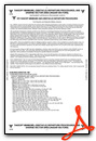
Instrument Approach Procedure (IAP) Charts
Nearby Airports with Instrument Procedures
| ID | Name | Heading / Distance | ||
|---|---|---|---|---|
 |
KLRG | Lincoln Regional Airport | 159° | 18.3 |
|
3B1 | Greenville Municipal Airport | 253° | 38.2 |
|
52B | Moosehead Aero Marine Seaplane Base | 255° | 40.1 |
|
KOLD | Dewitt Field/Old Town Municipal Airport | 179° | 41.7 |
|
1B0 | Dexter Regional Airport | 211° | 45.1 |
|
KHUL | Houlton International Airport | 052° | 47.1 |
|
KBGR | Bangor International Airport | 186° | 50.8 |
|
KPNN | Princeton Municipal Airport | 119° | 54.4 |
|
2B7 | Pittsfield Municipal Airport | 209° | 60.3 |
|
43B | Deblois Flight Strip Airport | 151° | 62.6 |
|
59B | Newton Field Airport | 269° | 65.8 |
|
KPQI | Presque Isle International Airport | 022° | 68.0 |
Airport Images
Do you have a recent image of this airport? Upload it here!


