Login
Register


MPO
Pocono Mountains Regional Airport
Official FAA Data Effective 2024-03-21 0901Z
Chart Supplement

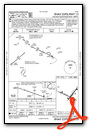
VFR Chart of KMPO
Sectional Charts at SkyVector.com
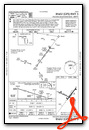
IFR Chart of KMPO
Enroute Charts at SkyVector.com
Location Information for KMPO
Coordinates: N41°8.26' / W75°22.80'Located 02 miles NW of Mount Pocono, Pennsylvania on 275 acres of land. View all Airports in Pennsylvania.
Surveyed Elevation is 1915 feet MSL.
Operations Data
|
|
Airport Communications
| ASOS: | 120.275 Tel. 570-839-1584 |
|---|---|
| WILKES-BARRE APPROACH: | 126.3 256.7 |
| WILKES-BARRE DEPARTURE: | 126.3 256.7 |
| CLEARANCE DELIVERY: | 125.3 |
| CTAF: | 122.700 |
| UNICOM: | 122.700 |
| ASOS at AVP (19.4 NW): | 570-655-0748 |
| ATIS at AVP (19.6 NW): | 135.75 |
| AWOS-3PT at 22N (26.2 SW): | 119.350 570-386-3423 |
Nearby Navigation Aids
|
| ||||||||||||||||||||||||||||||||||||||||||||||||||||||||||||


Runway 13/31
| Dimensions: | 5001 x 75 feet / 1524 x 23 meters | |
|---|---|---|
| Surface: | Asphalt in Excellent Condition | |
| Weight Limits: | S-30, D-45 | |
| Edge Lighting: | Medium Intensity | |
| Runway 13 | Runway 31 | |
| Coordinates: | N41°8.40' / W75°23.43' | N41°8.05' / W75°22.45' |
| Elevation: | 1884.9 | 1878.2 |
| Traffic Pattern: | Left | Left |
| Runway Heading: | 115° True | 295° True |
| Displaced Threshold: | 501 Feet | |
| Markings: | Non-Precision Instrument in good condition. | Non-Precision Instrument in good condition. |
| Glide Slope Indicator | P2L (3.00° Glide Path Angle) | P2L (3.50° Glide Path Angle) VGSI AND RNAV GLIDEPATH NOT COINCIDENT. |
| REIL: | Yes | Yes |
| Obstacles: | 42 ft Trees 663 ft from runway, 295 ft right of center RWY 13 27:1 SLOPE TO DTHR |
|
Runway 05/23
| Dimensions: | 3999 x 100 feet / 1219 x 30 meters | |
|---|---|---|
| Surface: | Asphalt in Good Condition | |
| Weight Limits: | S-30, D-45, ST-70 | |
| Edge Lighting: | Medium Intensity | |
| Runway 05 | Runway 23 | |
| Coordinates: | N41°8.04' / W75°22.89' | N41°8.57' / W75°22.37' |
| Elevation: | 1874.7 | 1915.2 |
| Traffic Pattern: | Left | Left |
| Runway Heading: | 37° True | 217° True |
| Markings: | Non-Precision Instrument in good condition. | Non-Precision Instrument in good condition. |
| Glide Slope Indicator | P2L (4.00° Glide Path Angle) | P2L (4.00° Glide Path Angle) |
| REIL: | Yes | Yes |
| Obstacles: | 23 ft Trees 593 ft from runway, 148 ft left of center | 37 ft Road 733 ft from runway |
Services Available
| Fuel: | 100LL (blue), Jet-A |
|---|---|
| Transient Storage: | Hangars,Tiedowns |
| Airframe Repair: | MAJOR |
| Engine Repair: | MAJOR |
| Bottled Oxygen: | NONE |
| Bulk Oxygen: | NONE |
| Other Services: | CHARTER SERVICE,PILOT INSTRUCTION,AIRCRAFT RENTAL |
Ownership Information
| Ownership: | Publicly owned | |
|---|---|---|
| Owner: | POCONO MTNS MUNI ARPT AUTH | |
| 188 AIRPORT DR | ||
| TOBYHANNA, PA 18466 | ||
| 570-839-0258 | ||
| Manager: | JUSTIN KLEIN | |
| 188 AIRPORT DR | ||
| TOBYHANNA, PA 18466 | ||
| (570) 839-0258 | ||
Operational Statistics
| Single Engine Aircraft Based on Field: | 40 | Statistics collected for 12 month period ending 2022-10-14 | |
|---|---|---|---|
| Multi-Engine Aircraft Based on Field: | 6 | Annual Commercial Operations: | none |
| Jet Aircraft Based on Field: | 1 | Annual Commuter Operations: | none |
| Helicopters Based on Field: | 4 | Annual Air Taxi Operations: | none |
| Military Aircraft Based on Field: | none | Annual Military Operations: | 300 |
| Gliders Based on Field: | none | Annual GA Local Operations: | 15500 |
| Ultralights Based on Field: | none | Annual GA Itinerant Operations: | 6500 |
Other Remarks
- BIRDS, DEER & OTHER WILDLIFE ON & INVOF ARPT.
- RWY 31 VFR DEP: FLY HDG 310 TILL CROSSING INTERSTATE 380, THEN PROCEED ON CRS AVOIDING OVERFLIGHT OF HOMES SW OF RWY 13-31.
- FOR SVC AFT HRS CALL 570-807-8966.
- 0LL 24 HR SELF SVC 100LL AVAIL.
- ACTVT REIL RWY 05, 13, 23 & 31; PAPI RWY 05, 13, 23 & 31; MIRL RWY 05/23 & 13/31 - CTAF.
- UNICOM 0800-DUSK DLY.
Weather Minimums
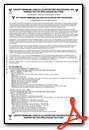
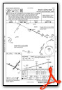
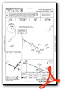
Instrument Approach Procedure (IAP) Charts
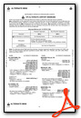
Nearby Airports with Instrument Procedures
| ID | Name | Heading / Distance | ||
|---|---|---|---|---|
 |
KAVP | Wilkes-Barre/Scranton International Airport | 307° | 19.7 |
|
1N7 | Blairstown Airport | 119° | 20.0 |
|
KWBW | Wilkes-Barre Wyoming Valley Airport | 294° | 23.4 |
|
N30 | Cherry Ridge Airport | 014° | 23.4 |
|
N43 | Braden Airpark Airport | 165° | 24.5 |
|
22N | Jake Arner Memorial Airport | 221° | 26.2 |
|
KHZL | Hazleton Regional Airport | 252° | 29.3 |
|
KABE | Lehigh Valley International Airport | 185° | 29.2 |
|
12N | Aeroflex/Andover Airport | 104° | 30.1 |
|
9N3 | Seamans Field Airport | 328° | 32.0 |
|
KFWN | Sussex Airport | 083° | 34.5 |
|
KXLL | Allentown Queen City Municipal Airport | 188° | 34.4 |
Airport Images
Do you have a recent image of this airport? Upload it here!


