Login
Register


MQJ
Indianapolis Regional Airport
Official FAA Data Effective 2024-04-18 0901Z
Chart Supplement

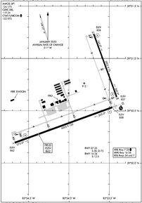
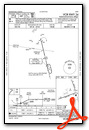
KMQJ Airport Diagram
VFR Chart of KMQJ
Sectional Charts at SkyVector.com
IFR Chart of KMQJ
Enroute Charts at SkyVector.com
Location Information for KMQJ
Coordinates: N39°50.59' / W85°53.86'Located 12 miles E of Indianapolis, Indiana on 1805 acres of land. View all Airports in Indiana.
Surveyed Elevation is 862 feet MSL.
Operations Data
|
|
Airport Communications
| AWOS-3PT: | 124.175 Tel. 317-335-3037 |
|---|---|
| INDIANAPOLIS APPROACH: | 127.15 317.8 |
| INDIANAPOLIS DEPARTURE: | 127.15 317.8 |
| CLEARANCE DELIVERY: | 119.25 |
| UNICOM: | 122.975 |
| CLANG STAR: | 128.175 317.8 |
| RACYR STAR: | 128.175 317.8 |
| CTAF: | 122.975 |
| AWOS-3PT at UMP (8.9 NW): | 119.375 317-842-3911 |
| AWOS-3 at 8A4 (12.5 W): | 135.525 317-955-3160 |
| AWOS-3 at 22L (12.6 W): | 127.075 317-964-9799 |
Nearby Navigation Aids
|
| ||||||||||||||||||||||||||||||||||||||||||||||||||||||||||||


Runway 07/25
| Dimensions: | 6005 x 100 feet / 1830 x 30 meters | |
|---|---|---|
| Surface: | Asphalt / Grooved in Excellent Condition | |
| Weight Limits: | S-30, D-75 | |
| Edge Lighting: | High Intensity | |
| Runway 07 | Runway 25 | |
| Coordinates: | N39°50.20' / W85°54.67' | N39°50.53' / W85°53.46' |
| Elevation: | 862.2 | 858.0 |
| Traffic Pattern: | Left | Left |
| Runway Heading: | 70° True | 250° True |
| Markings: | Non-Precision Instrument in good condition. | Precision Instrument in good condition. |
| Glide Slope Indicator | P4L (3.00° Glide Path Angle) | P4L (3.00° Glide Path Angle) |
| Approach Lights: | MALSR 1,400 Foot Medium-intensity Approach Lighting System with runway alignment indicator lights. | |
| REIL: | Yes | |
Runway 16/34
| Dimensions: | 3902 x 75 feet / 1189 x 23 meters | |
|---|---|---|
| Surface: | Concrete in Good Condition | |
| Weight Limits: | S-12 | |
| Edge Lighting: | Medium Intensity | |
| Runway 16 | Runway 34 | |
| Coordinates: | N39°51.24' / W85°53.69' | N39°50.63' / W85°53.41' |
| Elevation: | 857.7 | 856.9 |
| Runway Heading: | 160° True | 340° True |
| Markings: | Non-Precision Instrument in good condition. | Non-Precision Instrument in good condition. |
| Glide Slope Indicator | P2L (3.00° Glide Path Angle) | P2L (3.00° Glide Path Angle) |
| REIL: | Yes | |
Services Available
| Fuel: | 100LL (blue), Jet-A, Jet A+ |
|---|---|
| Transient Storage: | Hangars,Tiedowns |
| Airframe Repair: | MAJOR |
| Engine Repair: | MAJOR |
| Bottled Oxygen: | HIGH/LOW |
| Bulk Oxygen: | NOT AVAILABLE |
| Other Services: | AIR FREIGHT SERVICES,CARGO HANDLING SERVICES,CHARTER SERVICE,PILOT INSTRUCTION,AIRCRAFT RENTAL,AIRCRAFT SALES |
Ownership Information
| Ownership: | Publicly owned | |
|---|---|---|
| Owner: | INDIANAPOLIS ARPT AUTHORITY | |
| 7800 COL. H. WEIR COOK MEMORIAL DR. | ||
| INDIANAPOLIS, IN 46241 | ||
| 317-487-5022 | ||
| Manager: | KEITH BERLEN | |
| 7800 COL. H. WEIR COOK MEMORIAL DR. | ||
| INDIANAPOLIS, IN 46241 | ||
| 317-487-5022 | ||
Operational Statistics
| Single Engine Aircraft Based on Field: | 127 | Statistics collected for 12 month period ending 2019-12-31 | |
|---|---|---|---|
| Multi-Engine Aircraft Based on Field: | 16 | Annual Commercial Operations: | none |
| Jet Aircraft Based on Field: | 26 | Annual Commuter Operations: | none |
| Helicopters Based on Field: | 1 | Annual Air Taxi Operations: | 7623 |
| Military Aircraft Based on Field: | none | Annual Military Operations: | none |
| Gliders Based on Field: | none | Annual GA Local Operations: | 16200 |
| Ultralights Based on Field: | 1 | Annual GA Itinerant Operations: | 23825 |
Other Remarks
- RWY 16/34 & TWY B NOT AVBL TO ACR WITH MORE THAN 30 PAX SEATS.
- FOR FUEL & SVC - 131.5
- FOR CD CTC INDIANAPOLIS APCH AT 317-227-5743.
- DUSK-DAWN; ACTVT MALSR RWY 25; HIRL RWY 07/25 - CTAF.
Weather Minimums

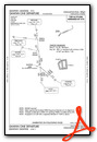
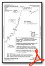
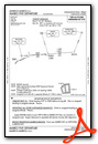
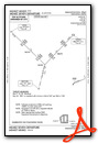
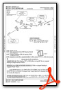
Standard Terminal Arrival (STAR) Charts
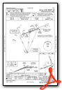
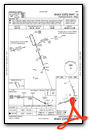
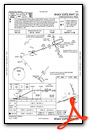
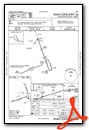
Instrument Approach Procedure (IAP) Charts
Departure Procedure (DP) Charts
Nearby Airports with Instrument Procedures
| ID | Name | Heading / Distance | ||
|---|---|---|---|---|
 |
KUMP | Indianapolis Metro Airport | 309° | 8.8 |
 |
8A4 | Indianapolis Downtown Heliport | 248° | 12.5 |
|
KHFY | Indy South Greenwood Airport | 214° | 15.6 |
|
KGEZ | Shelbyville Municipal Airport | 164° | 16.2 |
|
KEYE | Eagle Creek Airpark Airport | 267° | 18.3 |
|
KTYQ | Indianapolis Exec Airport | 304° | 19.8 |
|
KIND | Indianapolis International Airport | 247° | 19.8 |
|
KAID | Anderson Municipal-Darlington Field Airport | 039° | 20.6 |
|
5I4 | Sheridan Airport | 323° | 24.9 |
|
KUWL | New Castle Henry County Marlatt Field Airport | 085° | 26.5 |
|
2R2 | Hendricks County-Gordon Graham Field Airport | 257° | 27.3 |
|
KMIE | Delaware County Regional Airport | 043° | 33.3 |
Airport Images

By: 2flaps

By: flytripper


