Login
Register


MQW
Telfair-Wheeler Airport
Official FAA Data Effective 2024-04-18 0901Z
Chart Supplement

VFR Chart of KMQW
Sectional Charts at SkyVector.com
IFR Chart of KMQW
Enroute Charts at SkyVector.com
Location Information for KMQW
Coordinates: N32°5.82' / W82°52.76'Located 03 miles NE of Mc Rae, Georgia on 104 acres of land. View all Airports in Georgia.
Surveyed Elevation is 202 feet MSL.
Operations Data
|
|
Airport Communications
| AWOS-3PT: | 120.000 Tel. 229-868-7472 |
|---|---|
| CTAF: | 122.900 |
| AWOS-3 at EZM (14.5 NW): | 119.425 478-374-9979 |
| ATIS at EZM (14.6 NW): | 119.425 |
| AWOS-3 at AZE (17.7 SE): | 119.125 (912) 375-0650 |
- APCH/DEP SVC PRVDD BY JACKSONVILLE ARTCC ON FREQS 127.575/269.025 (ALMA RCAG).
Nearby Navigation Aids
|
| ||||||||||||||||||||||||||||||||||||||||||||||||||||||||||||


Runway 03/21
| Dimensions: | 5001 x 75 feet / 1524 x 23 meters | |
|---|---|---|
| Surface: | Asphalt in Fair Condition | |
| Weight Limits: | S-30 | |
| Edge Lighting: | Medium Intensity | |
| Runway 03 | Runway 21 | |
| Coordinates: | N32°5.44' / W82°52.95' | N32°6.20' / W82°52.58' |
| Elevation: | 201.9 | 192.6 |
| Traffic Pattern: | Left | Left |
| Runway Heading: | 23° True | 203° True |
| Markings: | Non-Precision Instrument in good condition. | Non-Precision Instrument in good condition. |
| Glide Slope Indicator | P2L (3.00° Glide Path Angle) | P2L (3.00° Glide Path Angle) |
| REIL: | Yes | |
| Obstacles: | 53 ft Trees 677 ft from runway, 307 ft left of center | 66 ft Trees 926 ft from runway, 310 ft left of center |
Services Available
| Fuel: | 100LL (blue), Jet A+ |
|---|---|
| Transient Storage: | Tiedowns |
| Airframe Repair: | NONE |
| Engine Repair: | NONE |
| Bottled Oxygen: | NONE |
| Bulk Oxygen: | NONE |
| Other Services: | CROP DUSTING SERVICES,PILOT INSTRUCTION |
Ownership Information
| Ownership: | Publicly owned | |
|---|---|---|
| Owner: | TELFAIR-WHEELER AIRPORT AUTH | |
| P.O. BOX 192 | ||
| MC RAE, GA 30411 | ||
| 229-315-1227 | ||
| Manager: | JIMMY RAY | |
| P.O. BOX 192 | ||
| MCRAE, GA 31055 | ||
| 229-315-1227 | ||
Operational Statistics
| Single Engine Aircraft Based on Field: | 11 | Statistics collected for 12 month period ending 2023-12-31 | |
|---|---|---|---|
| Multi-Engine Aircraft Based on Field: | 2 | Annual Commercial Operations: | none |
| Jet Aircraft Based on Field: | none | Annual Commuter Operations: | none |
| Helicopters Based on Field: | none | Annual Air Taxi Operations: | none |
| Military Aircraft Based on Field: | none | Annual Military Operations: | none |
| Gliders Based on Field: | none | Annual GA Local Operations: | 2200 |
| Ultralights Based on Field: | none | Annual GA Itinerant Operations: | 3500 |
Other Remarks
- FOR CD CTC JACKSONVILLE ARTCC AT 904-845-1592.
- WEATHER DATA SOURCES: AWOS 3PT 120.000 (229) 868-7472
- ACTVT REIL RWY 21; PAPI RWYS 03 & 21, MIRL RWY 03/21 - CTAF.
Weather Minimums

Instrument Approach Procedure (IAP) Charts
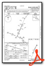
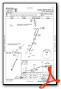
Nearby Airports with Instrument Procedures
| ID | Name | Heading / Distance | ||
|---|---|---|---|---|
 |
KEZM | Heart of Georgia Regional Airport | 299° | 14.6 |
|
KAZE | Hazlehurst Airport | 136° | 17.3 |
|
KVDI | Vidalia Regional Airport | 077° | 26.5 |
|
48A | Cochran Airport | 311° | 27.3 |
|
KDBN | W H 'Bud' Barron Airport | 349° | 28.5 |
|
KFZG | Fitzgerald Municipal Airport | 219° | 31.8 |
|
KBHC | Baxley Municipal Airport | 132° | 33.8 |
|
KRVJ | Swinton Smith Field At Reidsville Municipal Airport | 093° | 37.1 |
|
KDQH | Douglas Municipal Airport | 178° | 37.1 |
|
KAMG | Bacon County Airport | 150° | 38.6 |
|
KSBO | East Georgia Regional Airport | 040° | 40.1 |
|
KMHP | John Edwin Jones Sr Field/Metter Municipal Airport | 067° | 43.9 |
Airport Images
Do you have a recent image of this airport? Upload it here!


