Login
Register


MRT
Union County Airport
Official FAA Data Effective 2024-04-18 0901Z
Chart Supplement

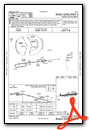
VFR Chart of KMRT
Sectional Charts at SkyVector.com
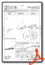
IFR Chart of KMRT
Enroute Charts at SkyVector.com
Location Information for KMRT
Coordinates: N40°13.47' / W83°21.10'Located 01 miles SE of Marysville, Ohio on 70 acres of land. View all Airports in Ohio.
Surveyed Elevation is 1020 feet MSL.
Operations Data
|
|
Airport Communications
| AWOS-3: | 119.275 Tel. 937-644-2967 |
|---|---|
| COLUMBUS APPROACH: | 125.95 317.775 |
| COLUMBUS DEPARTURE: | 125.95 317.775 |
| IC: | 125.95 317.775 |
| CTAF: | 122.800 |
| UNICOM: | 122.800 |
| AWOS-3 at DLZ (11.3 E): | 119.025 740-203-1878 |
| ASOS at OSU (15.3 SE): | 121.35 614-451-2465 |
| ATIS at OSU (15.5 SE): | 121.35 |
Nearby Navigation Aids
|
| ||||||||||||||||||||||||||||||||||||||||||||||||||||||||||||


Runway 09/27
| Dimensions: | 4218 x 75 feet / 1286 x 23 meters | |
|---|---|---|
| Surface: | Asphalt in Fair Condition | |
| Weight Limits: | S-17 | |
| Edge Lighting: | Medium Intensity | |
| Runway 09 | Runway 27 | |
| Coordinates: | N40°13.44' / W83°21.55' | N40°13.52' / W83°20.65' |
| Elevation: | 1020.6 | 996.8 |
| Traffic Pattern: | Left | Left CK NOTAMS FOR STS OF AEROBATIC BOX SOUTH OF RWY 09/27 & 08/26 - RP RWY 27 & 26 WHEN ACTV. |
| Runway Heading: | 83° True | 263° True |
| Displaced Threshold: | 123 Feet | |
| Markings: | Non-Precision Instrument in good condition. | Non-Precision Instrument in good condition. |
| Glide Slope Indicator | P4L (3.00° Glide Path Angle) | P4L (3.00° Glide Path Angle) |
| REIL: | Yes | Yes |
| Obstacles: | 20 ft Railroad 425 ft from runway, 260 ft right of center APCH RATIO 27:1 TO DTHR DUE TO +20 FT RR, 425 FT DIST, 260 FT R. |
|
Runway 08/26
| Dimensions: | 2702 x 81 feet / 824 x 25 meters | |
|---|---|---|
| Surface: | Turf in Good Condition | |
| Runway 08 | Runway 26 | |
| Coordinates: | N40°13.43' / W83°21.39' | N40°13.48' / W83°20.81' |
| Elevation: | 1015.2 | 993.9 |
| Runway Heading: | 83° True | 263° True |
Services Available
| Fuel: | 100LL (blue), Jet A-1, Jet A-1+ |
|---|---|
| Transient Storage: | Hangars,Tiedowns PRIOR CDN RQRD. |
| Airframe Repair: | MAJOR |
| Engine Repair: | MAJOR |
| Bottled Oxygen: | NONE |
| Bulk Oxygen: | NONE |
| Other Services: | PILOT INSTRUCTION,AIRCRAFT RENTAL |
Ownership Information
| Ownership: | Publicly owned | |
|---|---|---|
| Owner: | UNION COUNTY ARPT AUTH | |
| COUNTY COURTHOUSE, 215 W 5TH ST | ||
| MARYSVILLE, OH 43040 | ||
| 937-644-2055 | ||
| Manager: | DAVID HOLDEN | SKYVISTAAVIATION@GMAIL.COM. |
| 760 CLYMER RD | ||
| MARYSVILLE, OH 43040-9502 | ||
| 937-644-2055 | AFT HRS & EMERG 937-741-3120. | |
Operational Statistics
| Single Engine Aircraft Based on Field: | 54 | Statistics collected for 12 month period ending 2023-06-05 | |
|---|---|---|---|
| Multi-Engine Aircraft Based on Field: | 1 | Annual Commercial Operations: | none |
| Jet Aircraft Based on Field: | 1 | Annual Commuter Operations: | none |
| Helicopters Based on Field: | none | Annual Air Taxi Operations: | 675 |
| Military Aircraft Based on Field: | none | Annual Military Operations: | 2675 |
| Gliders Based on Field: | 1 | Annual GA Local Operations: | 19560 |
| Ultralights Based on Field: | none | Annual GA Itinerant Operations: | 9875 |
Other Remarks
- DEER, BIRDS, & OTR WILDLIFE ON & INVOF ARPT.
- FOR CD CTC COLUMBUS APCH AT 614-338-8537.
- RAMP FEE FOR COML ACFT.
- CALM WIND RWY.
- THR & EDGES MKD WITH CONES.
- THR & EDGES MKD WITH CONES.
- 0LL FUEL AVBL H24 SELF SVC VIA CREDIT CARD.
- ACTVT REIL RWY 09 & 27; PAPI RWY 09 & 27; MIRL RWY 09/27 - CTAF.
Weather Minimums

Instrument Approach Procedure (IAP) Charts
Nearby Airports with Instrument Procedures
| ID | Name | Heading / Distance | ||
|---|---|---|---|---|
 |
KDLZ | Delaware Municipal/Jim Moore Field Airport | 073° | 11.4 |
|
KOSU | Ohio State University Airport | 124° | 15.5 |
|
KUYF | Madison County Airport | 196° | 18.2 |
|
I74 | Grimes Field Airport | 253° | 19.3 |
|
KTZR | Bolton Field Airport | 152° | 21.8 |
|
KEDJ | Bellefontaine Regional Airport | 292° | 23.2 |
|
KCMH | John Glenn Columbus International Airport | 122° | 25.2 |
|
I95 | Hardin County Airport | 329° | 26.7 |
|
KMNN | Marion Municipal Airport | 029° | 26.9 |
|
4I9 | Morrow County Airport | 051° | 29.2 |
|
KLCK | Rickenbacker International Airport | 141° | 31.4 |
|
KSGH | Springfield/Beckley Municipal Airport | 224° | 32.2 |
Airport Images
Do you have a recent image of this airport? Upload it here!


