Login
Register


MTN
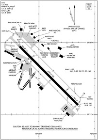
Martin State Airport
Official FAA Data Effective 2024-04-18 0901Z
Chart Supplement

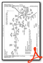
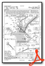
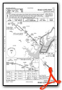
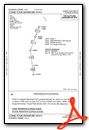
KMTN Airport Diagram
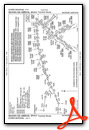
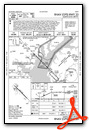
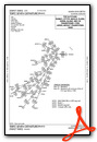
VFR Chart of KMTN
Sectional Charts at SkyVector.com
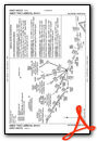
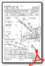
IFR Chart of KMTN
Enroute Charts at SkyVector.com
Location Information for KMTN
Coordinates: N39°19.54' / W76°24.83'Located 09 miles E of Baltimore, Maryland on 747 acres of land. View all Airports in Maryland.
Surveyed Elevation is 21 feet MSL.
TPA RECIPROCATING ENG ACFT 978 FT AGL; TURBOPROP & CIVIL JET ACFT 1478 FT AGL; MIL JET ACFT 1978 FT AGL.
Operations Data
|
|
Airport Communications
| ATIS: | 124.925 |
|---|---|
| AWOS-3PT: | 124.925 Tel. 410-682-8848 |
| MARTIN TOWER: | 121.3 254.425 |
| MARTIN GROUND: | 121.8 253.4 |
| POTOMAC APPROACH: | 119.0 119.7 282.275 290.475 |
| POTOMAC DEPARTURE: | 119.0 119.7 282.275 290.475 |
| CTAF: | 121.300 |
| EMERG: | 121.5 243.0 |
| COMD POST: | 139.6 ;175 WG 275.7 ;175 WG |
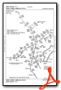
| WESTMINSTER STAR: | 126.825 ;10000 FT & BLW 133.85 ;11000 FT & ABV 239.025 ;10000 FT & BLW 254.25 ;11000 FT & ABV |
| RAVNN STAR: | 128.35 270.275 |
| TRISH STAR: | 125.525 291.625 |
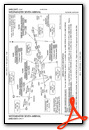
| TERPZ DP: | 119.7 290.475 |
| ANTHM STAR: | 133.85 254.25 |
| MIIDY STAR: | 133.75 254.35 |
| UNICOM: | 122.950 |
| ATIS at APG (14.1 NE): | 124.425 |
| ASOS at BWI (14.9 SW): | 410-691-1278 |
| D-ATIS at BWI (14.9 SW): | 127.8 |
- ATCT OWNED BY STATE AND OPERD BY BARTON ATC INC.
- ATIS FREQ 124.925 USED TO TMT AWOS WX DATA WHEN ATCT CLOSES.
Nearby Navigation Aids
|
| ||||||||||||||||||||||||||||||||||||||||||||||||||||||||||||


Runway 15/33
8100 FT AVBL FOR TKOF RWY 15 AND LNDG RWY 33 FOR MIL ACFT ONLY. | ||
| Dimensions: | 6997 x 180 feet / 2133 x 55 meters | |
|---|---|---|
| Surface: | Asphalt / Grooved in Good Condition | |
| Weight Limits: | S-65, D-82, ST-140 | |
| Edge Lighting: | High Intensity | |
| Runway 15 | Runway 33 | |
| Coordinates: | N39°19.95' / W76°25.35' | N39°19.13' / W76°24.30' |
| Elevation: | 21.3 | 9.2 |
| Traffic Pattern: | Left | Left |
| Runway Heading: | 135° True | 315° True |
| Markings: | Non-Precision Instrument in good condition. | Precision Instrument in good condition. |
| Glide Slope Indicator | PSIL (4.01° Glide Path Angle) UNUSBL BYD 5 DEGS EITHER SIDE OF CENTERLINE. | PSIL (2.91° Glide Path Angle) |
| REIL: | Yes | Yes |
| Obstacles: | 84 ft Trees 2224 ft from runway, 77 ft left of center BOAT MAST |
|
Services Available
| Fuel: | 100LL (blue), Jet A+ |
|---|---|
| Transient Storage: | Hangars,Tiedowns |
| Airframe Repair: | MINOR |
| Engine Repair: | MINOR |
| Bottled Oxygen: | NONE |
| Bulk Oxygen: | NONE |
| Other Services: | AIR AMBULANCE SERVICES,AVIONICS,CHARTER SERVICE,PILOT INSTRUCTION,AIRCRAFT RENTAL |
Ownership Information
| Ownership: | Publicly owned | |
|---|---|---|
| Owner: | MAA | MARYLAND AVN ADMIN. |
| BOX 1 701 WILSON PT RD | ||
| BALTIMORE, MD 21220 | ||
| 410-682-8800 | ||
| Manager: | HAROLD A. FOWLER | |
| BOX 1, 701 WILSON POINT RD | ||
| BALTIMORE, MD 21220 | ||
| 410-682-8800 | ||
Operational Statistics
| Single Engine Aircraft Based on Field: | 161 | Statistics collected for 12 month period ending 2023-10-13 | |
|---|---|---|---|
| Multi-Engine Aircraft Based on Field: | 14 | Annual Commercial Operations: | 6 |
| Jet Aircraft Based on Field: | 19 | Annual Commuter Operations: | none |
| Helicopters Based on Field: | 21 | Annual Air Taxi Operations: | 2846 |
| Military Aircraft Based on Field: | 21 | Annual Military Operations: | 2689 |
| Gliders Based on Field: | 1 | Annual GA Local Operations: | 48397 |
| Ultralights Based on Field: | none | Annual GA Itinerant Operations: | 40827 |
Other Remarks
- NOISE ABATEMENT PROCS IN EFCT. WHEN ATCT CLSD NO PRACTICE LNDGS OR APCHS.
- BEARING STRENGTH RWY 15/33: ST175.
- CAUTION: BASH II IN EFFECT AUG-JAN.
- RMKS-ANG: CALL COMD POST/RAVEN OPS 275.500 OR 139.900 10 MIN PRIOR TO LNDG.
- RMKS-ANG: NO SPACE A, FLEET SVC, OR TRAN QTRS AVBL. PPR AFTER DUTY HR RQR OG/CC APVL.
- RMKS-ANG: C-5/C-17 ACFT RSTRD TO TWY A.
- RMKS-ANG: PPR FOR SVC AND USE OF ANG PRK RAMP ONLY, DSN 243-6630/6637/6444, C410-918-6630/6637/6444; AFTER DUTY HR CTC C410-698-8947.
- FOR CD WHEN TWR CLSD CTC POTOMAC APCH AT 866-429-5882.
- ARFF SVCS AVBL 24 HRS DAILY. FOR ARFF SVCS WHEN ATCT CLSD CTC ARFF STATION; CTAF OR 410-918-6257 / 410-918-6911.
- NO ACFT ACCESS TO TWY S FM STRAWBERRY POINT RAMP.
- SEAGULLS ON & INVOF ARPT.
- ARPT CONDS UNMON 2300-0600.
- MOWING OPS CONDUCTED DURG DALGT.
- PPR FOR PRACTICE TKOFS & LNDGS FOR ACFT WEIGHING MORE THAN 12500 LBS.
- RECREATIONAL SAILBOAT MASTS TO +50 FT & MOTOR BOATS IN WATERWAY AT AER 33 813 FT FM THR ON CNTRLN.
- FOR ADDL INFO CTC AMGR 410-682-8800.
- 0LL 24 HR SELF SERVE 100LL AVBL WITH CREDIT CARD. HELIS NOT AUTH TO ACES THE 100-LL SELF SVC STN UNDER OWN PWR.
- DUSK-DAWN. WHEN ATCT CLSD ACTVT REIL RWYS 15 & 33; HIRL RWY 15/33 - CTAF. WHEN ATCT CLSD ACTVT TWY F LGTS - UNICOM.
- TPA RECIPROCATING ENG ACFT 978 FT AGL; TURBOPROP & CIVIL JET ACFT 1478 FT AGL; MIL JET ACFT 1978 FT AGL.
Weather Minimums
Standard Terminal Arrival (STAR) Charts

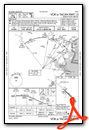
Instrument Approach Procedure (IAP) Charts
Departure Procedure (DP) Charts
Nearby Airports with Instrument Procedures
| ID | Name | Heading / Distance | ||
|---|---|---|---|---|
 |
KBWI | Baltimore/Washington International Thurgood Marshall Airport | 233° | 14.9 |
|
0W3 | Harford County Airport | 033° | 17.5 |
|
W29 | Bay Bridge Airport | 169° | 21.3 |
|
KFME | Tipton Airport | 228° | 21.6 |
|
KANP | Lee Airport | 197° | 24.1 |
|
W00 | Freeway Airport | 216° | 28.5 |
|
2W2 | Clearview Airpark Airport | 286° | 29.3 |
|
58M | Claremont Airport | 059° | 29.3 |
|
KCGS | College Park Airport | 229° | 31.5 |
|
KDMW | Carroll County Regional/Jack B Poage Field Airport | 301° | 32.4 |
|
KRJD | Gooden Airpark Airport | 129° | 33.3 |
|
KEVY | Summit Airport | 069° | 34.2 |


