Login
Register


MXA
Manila Municipal Airport
Official FAA Data Effective 2024-04-18 0901Z
Chart Supplement

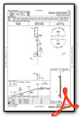
VFR Chart of KMXA
Sectional Charts at SkyVector.com
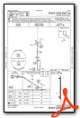
IFR Chart of KMXA
Enroute Charts at SkyVector.com
Location Information for KMXA
Coordinates: N35°53.67' / W90°9.27'Located 02 miles NE of Manila, Arkansas on 630 acres of land. View all Airports in Arkansas.
Surveyed Elevation is 242 feet MSL.
Operations Data
|
|
Airport Communications
| CTAF: | 122.800 |
|---|---|
| UNICOM: | 122.800 |
| ASOS at HKA (15.9 E): | 135.025 870-763-8206 |
| AWOS-3PT at TKX (20.5 N): | 119.05 573-888-9640 |
| ASOS at JBR (24.1 W): | 118.525 870-932-4010 |
- APCH/DEP SVC PRVDD BY MEMPHIS ARTCC ON FREQS 120.075/289.4 (WALNUT RIDGE RCAG).
Nearby Navigation Aids
|
| ||||||||||||||||||||||||||||||||||||||||||||||||||||||||||||


Runway 18/36
| Dimensions: | 4201 x 75 feet / 1280 x 23 meters | |
|---|---|---|
| Surface: | Asphalt in Good Condition | |
| Weight Limits: | S-15 | |
| Edge Lighting: | Medium Intensity | |
| Runway 18 | Runway 36 | |
| Coordinates: | N35°54.01' / W90°9.27' | N35°53.32' / W90°9.28' |
| Elevation: | 240.8 | 242.7 |
| Traffic Pattern: | Left | Right |
| Runway Heading: | 180° True | 0 |
| Displaced Threshold: | 60 Feet | |
| Markings: | Non-Precision Instrument in good condition. | Non-Precision Instrument in good condition. |
| Glide Slope Indicator | P2R (4.00° Glide Path Angle) | P2L (4.00° Glide Path Angle) |
| REIL: | Yes | Yes |
| Obstacles: | 75 ft Tree 2300 ft from runway | 14 ft Road 495 ft from runway APCH SLOPE 34:1 TO DSPLCD THLD. |
Services Available
| Fuel: | 100LL (blue) |
|---|---|
| Transient Storage: | Tiedowns |
| Airframe Repair: | MAJOR |
| Engine Repair: | MAJOR |
| Bottled Oxygen: | NONE |
| Bulk Oxygen: | NONE |
| Other Services: | CROP DUSTING SERVICES,PILOT INSTRUCTION |
Ownership Information
| Ownership: | Publicly owned | |
|---|---|---|
| Owner: | CITY OF MANILA | |
| PO BOX 895 | ||
| MANILA, AR 72442 | ||
| 870-561-4437 | ||
| Manager: | JOHN GEARHART | |
| PO BOX 895 | ||
| MANILA, AR 72442 | ||
| 479-757-0722 | ||
Operational Statistics
| Single Engine Aircraft Based on Field: | 20 | Statistics collected for 12 month period ending 2019-03-31 | |
|---|---|---|---|
| Multi-Engine Aircraft Based on Field: | 3 | Annual Commercial Operations: | none |
| Jet Aircraft Based on Field: | none | Annual Commuter Operations: | none |
| Helicopters Based on Field: | none | Annual Air Taxi Operations: | none |
| Military Aircraft Based on Field: | none | Annual Military Operations: | 100 |
| Gliders Based on Field: | none | Annual GA Local Operations: | 30000 |
| Ultralights Based on Field: | none | Annual GA Itinerant Operations: | 1000 |
Other Remarks
- NUMEROUS AGRICULTURAL ACFT OPNS FM FEB-NOV 500 FT AGL & BLO.
- FOR CD CTC MEMPHIS ARTCC AT 901-368-8453/8449.
- 0LL FOR SVC AFT HRS CALL 901-605-1094 OUR 479-757-0722 NO FEE. FUEL AVBL WITH CREDIT CARD 8AM TO 5PM.
- ACTVT REIL RWYS 18 & 36; MIRL RWY 18/36; AND PAPI RWYS 18 & 36 - CTAF. LOCAL ARPT WX 4 CLICKS
- 4 CLICKS FOR TEMP, WIND, AND DENSITY ALT.
Weather Minimums

Instrument Approach Procedure (IAP) Charts
Nearby Airports with Instrument Procedures
| ID | Name | Heading / Distance | ||
|---|---|---|---|---|
 |
KBYH | Arkansas International Airport | 067° | 11.1 |
|
7M4 | Osceola Municipal Airport | 149° | 14.1 |
|
KHKA | Blytheville Municipal Airport | 080° | 16.0 |
|
M12 | Steele Municipal Airport | 049° | 18.8 |
|
KPGR | Kirk Field Airport | 300° | 20.0 |
|
KTKX | Kennett Memorial Airport | 016° | 20.7 |
|
KJBR | Jonesboro Municipal Airport | 261° | 24.3 |
|
M05 | Caruthersville Memorial Airport | 054° | 28.5 |
|
M04 | Covington Municipal Airport | 123° | 33.4 |
|
KNQA | Millington/Memphis Airport | 156° | 35.1 |
|
M85 | Gideon Memorial Airport | 020° | 35.1 |
|
KDYR | Dyersburg Regional Airport | 080° | 37.0 |
Airport Images
Do you have a recent image of this airport? Upload it here!


