Login
Register


MXO
Monticello Regional Airport
Official FAA Data Effective 2024-04-18 0901Z
Chart Supplement

VFR Chart of KMXO
Sectional Charts at SkyVector.com
IFR Chart of KMXO
Enroute Charts at SkyVector.com
Location Information for KMXO
Coordinates: N42°13.22' / W91°9.80'Located 02 miles SE of Monticello, Iowa on 300 acres of land. View all Airports in Iowa.
Surveyed Elevation is 833 feet MSL.
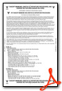
Operations Data
|
|
Airport Communications
| AWOS-3: | 119.275 Tel. 319-465-6155 |
|---|---|
| CEDAR RAPIDS APPROACH: | 134.05 266.8 |
| CEDAR RAPIDS DEPARTURE: | 134.05 266.8 |
| UNICOM: | 122.800 |
| CTAF: | 122.800 |
| ASOS at DBQ (22.9 NE): | 563-557-2579 |
| ATIS at DBQ (22.9 NE): | 127.25 |
| ASOS at CID (31.7 SW): | 319-558-5153 |
- APCH/DEP SVC PRVDD BY CHICAGO ARTCC ON FREQS 132.8/328.4 (CEDAR RAPIDS RCAG) WHEN CEDAR RAPIDS APCH CTL CLSD.
Nearby Navigation Aids
|
| ||||||||||||||||||||||||||||||||||||||||||||||||


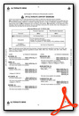
Runway 15/33
| Dimensions: | 4400 x 75 feet / 1341 x 23 meters | |
|---|---|---|
| Surface: | Concrete in Good Condition | |
| Weight Limits: | 6 /R/C/W/U, S-12 | |
| Edge Lighting: | Medium Intensity | |
| Runway 15 | Runway 33 | |
| Coordinates: | N42°13.59' / W91°10.06' | N42°12.94' / W91°9.63' |
| Elevation: | 825.7 | 829.8 |
| Runway Heading: | 154° True | 334° True |
| Markings: | Non-Precision Instrument in good condition. | Non-Precision Instrument in good condition. |
| Glide Slope Indicator | P2L (3.00° Glide Path Angle) | P2L (3.00° Glide Path Angle) |
| REIL: | Yes | Yes |
| Obstacles: | 61 ft Road 1601 ft from runway, 171 ft right of center | 97 ft Trees 3000 ft from runway, 137 ft right of center |
Runway 09/27
| Dimensions: | 2300 x 90 feet / 701 x 27 meters | |
|---|---|---|
| Surface: | Turf in Fair Condition | |
| Runway 09 | Runway 27 | |
| Coordinates: | N42°13.14' / W91°9.96' | N42°13.14' / W91°9.45' |
| Elevation: | 823.5 | 832.7 |
| Runway Heading: | 90° True | 270° True |
| Markings: | Non-Standard in fair condition. | Non-Standard in fair condition. |
| Obstacles: | 23 ft Trees 429 ft from runway, 99 ft right of center | 23 ft Road 513 ft from runway |
Services Available
| Fuel: | 100LL (blue), Jet-A |
|---|---|
| Transient Storage: | Hangars,Tiedowns |
| Airframe Repair: | MAJOR |
| Engine Repair: | MAJOR |
| Bottled Oxygen: | LOW |
| Bulk Oxygen: | NONE |
| Other Services: | PILOT INSTRUCTION,AIRCRAFT RENTAL |
Ownership Information
| Ownership: | Publicly owned | |
|---|---|---|
| Owner: | CITY OF MONTICELLO | |
| 102 W. 1ST ST. | ||
| MONTICELLO, IA 52310 | ||
| 319-465-3526 | ||
| Manager: | BRIAN OSTWINKLE...FBO | |
| BOX 168 20373 HWY 38 S | ||
| MONTICELLO, IA 52310 | ||
| 319-465-5488 | HOME PHONE 563-543-0503 | |
Operational Statistics
| Single Engine Aircraft Based on Field: | 25 | Statistics collected for 12 month period ending 2022-06-07 | |
|---|---|---|---|
| Multi-Engine Aircraft Based on Field: | 5 | Annual Commercial Operations: | none |
| Jet Aircraft Based on Field: | 1 | Annual Commuter Operations: | none |
| Helicopters Based on Field: | none | Annual Air Taxi Operations: | 813 |
| Military Aircraft Based on Field: | none | Annual Military Operations: | none |
| Gliders Based on Field: | none | Annual GA Local Operations: | 6067 |
| Ultralights Based on Field: | none | Annual GA Itinerant Operations: | 5720 |
Other Remarks
- RY 33 IS CALM WIND RY.
- FOR CD CTC CHICAGO ARTCC AT 630-906-8921.
- 0LL 24 HR SELF SVC FUEL.
- ACTVT MIRL RY 15/33; REIL AND PAPI RYS 15 & 33- CTAF.
Weather Minimums
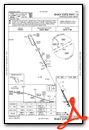
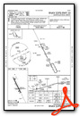
Instrument Approach Procedure (IAP) Charts
Nearby Airports with Instrument Procedures
| ID | Name | Heading / Distance | ||
|---|---|---|---|---|
 |
C17 | Marion Airport | 235° | 20.0 |
|
KOQW | Maquoketa Municipal Airport | 118° | 21.5 |
|
KDBQ | Dubuque Regional Airport | 061° | 23.0 |
|
8C4 | Mathews Memorial Airport | 179° | 27.4 |
|
KCID | The Eastern Iowa Airport | 230° | 31.7 |
|
KIIB | James H Connell Field At Independence Municipal Airport | 292° | 37.7 |
|
KVTI | Vinton Veterans Memorial Airpark Airport | 270° | 38.5 |
|
KIOW | Iowa City Municipal Airport | 206° | 38.9 |
|
KPVB | Platteville Municipal Airport | 048° | 42.6 |
|
KCWI | Clinton Municipal Airport | 121° | 44.0 |
|
KDVN | Davenport Municipal Airport | 144° | 44.7 |
|
KOLZ | Oelwein Municipal Airport | 307° | 45.4 |
Airport Images

By: bryjguy


