Login
Register


MYJ
Mexico Memorial Airport
Official FAA Data Effective 2024-04-18 0901Z
Chart Supplement

VFR Chart of KMYJ
Sectional Charts at SkyVector.com
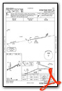
IFR Chart of KMYJ
Enroute Charts at SkyVector.com
Location Information for KMYJ
Coordinates: N39°9.45' / W91°49.10'Located 03 miles E of Mexico, Missouri on 290 acres of land. View all Airports in Missouri.
Surveyed Elevation is 822 feet MSL.
Operations Data
|
|
Airport Communications
| AWOS-3PT: | 120.575 Tel. 573-581-7868 |
|---|---|
| MIZZU APPROACH: | 124.375 |
| MIZZU DEPARTURE: | 124.375 |
| CTAF: | 122.900 |
| ATIS at COU (27.6 SW): | 128.45 |
| ASOS at COU (27.7 SW): | 128.45 573-499-1400 |
| AWOS-3PT at MBY (33.6 NW): | 120.025 660-269-8028 |
Nearby Navigation Aids
|
| ||||||||||||||||||||||||||||||||||||||||||||||||||||||||||||


Runway 06/24
| Dimensions: | 5501 x 100 feet / 1677 x 30 meters | |
|---|---|---|
| Surface: | Concrete in Good Condition | |
| Weight Limits: | S-30, D-37 | |
| Edge Lighting: | Medium Intensity | |
| Runway 06 | Runway 24 | |
| Coordinates: | N39°9.26' / W91°49.53' | N39°9.63' / W91°48.47' |
| Elevation: | 822.6 | 808.4 |
| Traffic Pattern: | Left | Left |
| Runway Heading: | 66° True | 246° True |
| Displaced Threshold: | 200 Feet | 371 Feet |
| Markings: | Non-Precision Instrument in good condition. | Non-Precision Instrument in good condition. |
| Glide Slope Indicator | P4L (3.00° Glide Path Angle) | |
| Approach Lights: | MALS 1,400 Foot Medium-intensity Approach Lighting System. | |
| Obstacles: | 59 ft Trees 1770 ft from runway, 278 ft right of center RWY 24 36:1 BASED ON DSPLCD THR. |
|
Runway 18/36
| Dimensions: | 3200 x 50 feet / 975 x 15 meters | |
|---|---|---|
| Surface: | Asphalt-Concrete in Fair Condition | |
| Weight Limits: | S-10 | |
| Edge Lighting: | Medium Intensity | |
| Runway 18 | Runway 36 | |
| Coordinates: | N39°9.73' / W91°49.25' | N39°9.20' / W91°49.27' |
| Elevation: | 811.6 | 817.9 |
| Traffic Pattern: | Left | Left |
| Runway Heading: | 182° True | 2° True |
| Markings: | Basic in good condition. | Basic in good condition. |
| REIL: | Yes | |
Services Available
| Fuel: | 100LL (blue), Jet-A, Automotive Gasoline |
|---|---|
| Transient Storage: | Tiedowns |
| Airframe Repair: | MAJOR |
| Engine Repair: | MAJOR |
| Bottled Oxygen: | NONE |
| Bulk Oxygen: | NONE |
| Other Services: | CROP DUSTING SERVICES,PILOT INSTRUCTION,AIRCRAFT RENTAL |
Ownership Information
| Ownership: | Publicly owned | |
|---|---|---|
| Owner: | CITY OF MEXICO | |
| 300 N. COAL | ||
| MEXICO, MO 65265 | ||
| 573-581-2100 | ||
| Manager: | JAY JACOBI | |
| 5720 HWY 54 EAST | ||
| MEXICO, MO 65265 | ||
| 573-581-0162 | ||
Operational Statistics
| Single Engine Aircraft Based on Field: | 18 | Statistics collected for 12 month period ending 2021-12-31 | |
|---|---|---|---|
| Multi-Engine Aircraft Based on Field: | 6 | Annual Commercial Operations: | none |
| Jet Aircraft Based on Field: | none | Annual Commuter Operations: | none |
| Helicopters Based on Field: | none | Annual Air Taxi Operations: | 1650 |
| Military Aircraft Based on Field: | none | Annual Military Operations: | 56 |
| Gliders Based on Field: | none | Annual GA Local Operations: | 2682 |
| Ultralights Based on Field: | none | Annual GA Itinerant Operations: | 12820 |
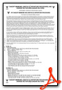
Other Remarks
- CROP DUSTING ACFT ON & INVOF ARPT.
- FOR CD CTC MIZZOU APCH AT 417-868-5620/5619.
- 0LL 100LL 24 HR CREDIT CARD FUEL SYSTEM. FOR JET A FUEL AFTER HRS CALL AIRPORT MGR 573-473-7758.
- ACTVT MALS RWY 24; REIL RWY 18; PAPI RWY 24 - CTAF. MIRL RWY 06/24 & 18/36 SS-SR LOW INTST; INCR INTST - CTAF.
Weather Minimums
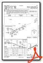
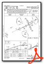
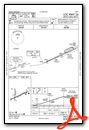
Instrument Approach Procedure (IAP) Charts
Nearby Airports with Instrument Procedures
| ID | Name | Heading / Distance | ||
|---|---|---|---|---|
 |
KFTT | Elton Hensley Memorial Airport | 204° | 21.0 |
|
KCOU | Columbia Regional Airport | 222° | 27.6 |
|
K52 | Cpt Ben Smith Airfield - Monroe City Airport | 008° | 28.9 |
|
H19 | Bowling Green Municipal Airport | 065° | 30.7 |
|
KMBY | Omar N Bradley Airport | 303° | 33.7 |
|
KJEF | Jefferson City Memorial Airport | 205° | 37.5 |
|
KHAE | Hannibal Regional Airport | 026° | 38.2 |
|
KVER | Jesse Viertel Memorial Airport | 252° | 42.3 |
|
K89 | Macon-Fower Memorial Airport | 319° | 45.4 |
|
KFYG | Washington Regional Airport | 131° | 51.6 |
|
KUIN | Quincy Regional-Baldwin Field Airport | 031° | 55.3 |
|
KPPQ | Pittsfield Penstone Municipal Airport | 058° | 56.3 |
Airport Images

By: Big Orange Bird


