Login
Register


N79
Northumberland County Airport
Official FAA Data Effective 2024-03-21 0901Z
Chart Supplement

VFR Chart of N79
Sectional Charts at SkyVector.com
IFR Chart of N79
Enroute Charts at SkyVector.com
Location Information for N79
Coordinates: N40°50.22' / W76°33.15'Located 03 miles N of Shamokin, Pennsylvania on 125 acres of land. View all Airports in Pennsylvania.
Surveyed Elevation is 880 feet MSL.
Operations Data
|
|
Airport Communications
| AWOS-3: | 119.175 Tel. 570-672-0389 |
|---|---|
| HARRISBURG APPROACH: | 118.25 269.45 |
| HARRISBURG DEPARTURE: | 118.25 269.45 |
| UNICOM: | 122.800 |
| CTAF: | 122.800 |
| AWOS-3 at 79PN (8.2 N): | 118.075 570-271-8192 |
| AWOS-3 at ZER (11.3 SE): | 127.575 570-544-2778 |
| ASOS at SEG (14.2 W): | 123.975 570-374-4099 |
Nearby Navigation Aids
|
| ||||||||||||||||||||||||||||||||||||||||||||||||


Runway 08/26
| Dimensions: | 3297 x 75 feet / 1005 x 23 meters | |
|---|---|---|
| Surface: | Asphalt in Fair Condition | |
| Weight Limits: | S-12 | |
| Edge Lighting: | Medium Intensity | |
| Runway 08 | Runway 26 | |
| Coordinates: | N40°50.13' / W76°33.49' | N40°50.30' / W76°32.81' |
| Elevation: | 852.5 | 880.5 |
| Traffic Pattern: | Left | Left |
| Runway Heading: | 72° True | 252° True |
| Markings: | Non-Precision Instrument in fair condition. | Non-Precision Instrument in fair condition. |
| Glide Slope Indicator | P2L (3.00° Glide Path Angle) | P2L (3.00° Glide Path Angle) |
| REIL: | Yes | Yes |
| Obstacles: | 18 ft Trees 395 ft from runway, 257 ft left of center RWY 08 TREES/BRUSH 165 L OF CNTRLN PARL TO RWY FROM THLD OUT TO 200 FT. |
|
Services Available
| Fuel: | 100LL (blue), Jet-A |
|---|---|
| Transient Storage: | Tiedowns |
| Airframe Repair: | MAJOR |
| Engine Repair: | MAJOR |
| Bottled Oxygen: | NONE |
| Bulk Oxygen: | NONE |
Ownership Information
| Ownership: | Publicly owned | |
|---|---|---|
| Owner: | NORTHUMBERLAND CO APT AUTH | |
| PO BOX 94 | ||
| PAXINOS, PA 17860 | ||
| 570-898-8588 | AFTER HOURS 570-898-8588 | |
| Manager: | RON SMITH | |
| PO BOX 94 | ||
| PAXINOS, PA 17860 | ||
| 570-898-8588 | ||
Operational Statistics
| Single Engine Aircraft Based on Field: | 13 | Statistics collected for 12 month period ending 2023-02-21 | |
|---|---|---|---|
| Multi-Engine Aircraft Based on Field: | 2 | Annual Commercial Operations: | none |
| Jet Aircraft Based on Field: | none | Annual Commuter Operations: | none |
| Helicopters Based on Field: | 1 | Annual Air Taxi Operations: | none |
| Military Aircraft Based on Field: | none | Annual Military Operations: | 150 |
| Gliders Based on Field: | none | Annual GA Local Operations: | 15000 |
| Ultralights Based on Field: | none | Annual GA Itinerant Operations: | 8000 |
Other Remarks
- FOR CD CTC HARRISBURG APCH AT 800-932-0712.
- ACTVT PAPI RY 08/26; MIRL RY 08/26 - 121.8.
Weather Minimums
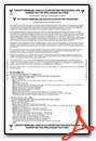
Instrument Approach Procedure (IAP) Charts
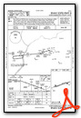
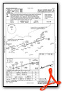
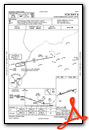
Nearby Airports with Instrument Procedures
| ID | Name | Heading / Distance | ||
|---|---|---|---|---|
 |
8N8 | Danville Airport | 328° | 7.9 |
|
N13 | Bloomsburg Municipal Airport | 028° | 11.0 |
|
KZER | Schuylkill County/Joe Zerbey Airport | 133° | 11.3 |
|
KSEG | Penn Valley Airport | 266° | 14.2 |
|
74N | Bendigo Airport | 181° | 16.7 |
|
KHZL | Hazleton Regional Airport | 070° | 26.9 |
|
KIPT | Williamsport Regional Airport | 325° | 29.5 |
|
9D4 | Deck Airport | 160° | 30.8 |
|
58N | Reigle Field Airport | 181° | 33.0 |
|
08N | Keller Brothers Airport | 162° | 34.3 |
|
22N | Jake Arner Memorial Airport | 092° | 36.1 |
|
KRDG | Reading Regional/Carl A Spaatz Field Airport | 135° | 38.4 |

")


