Login
Register


OAJ
Albert J Ellis Airport
Official FAA Data Effective 2024-03-21 0901Z
Chart Supplement

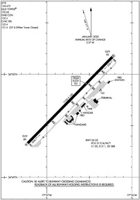
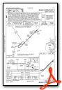
KOAJ Airport Diagram
VFR Chart of KOAJ
Sectional Charts at SkyVector.com
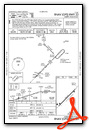
IFR Chart of KOAJ
Enroute Charts at SkyVector.com
Location Information for KOAJ
Coordinates: N34°49.75' / W77°36.73'Located 10 miles NW of Jacksonville, North Carolina on 675 acres of land. View all Airports in North Carolina.
Surveyed Elevation is 92 feet MSL.
Operations Data
|
|
Airport Communications
| ATIS: | 124.475 (910 324-5233) |
|---|---|
| AWOS-3PT: | Tel. 910-324-5233 |
| ELLIS TOWER TOWER: | 132.65 |
| ELLIS TOWER GROUND: | 125.4 |
| WILMINGTON APPROACH: | 135.75 317.425 ;344-163 |
| WILMINGTON DEPARTURE: | 135.75 317.425 ;344-163 |
| CLEARANCE DELIVERY: | 125.4 121.4 ;WHEN TWR CLSD 257.6 ;WHEN TWR CLSD |
| CTAF: | 132.650 |
| UNICOM: | 122.950 |
| ASOS at NCA (11.2 SE): | 288.325 |
| ATIS at NCA (11.2 SE): | 288.325 |
| AWOS-3P at ACZ (20.5 W): | 121.07 910-285-0419 |
- APCH/DEP SVC PRVDD BY WASHINGTON ARTCC ON FREQS 135.75/269.15 (WILMINGTON RCAG) WHEN WILMINGTON APCH CTL CLSD.
Nearby Navigation Aids
|
| ||||||||||||||||||||||||||||||||||||||||||||||||||||||||||||


Runway 05/23
| Dimensions: | 7100 x 150 feet / 2164 x 46 meters | |
|---|---|---|
| Surface: | Asphalt / Grooved in Good Condition | |
| Weight Limits: | 51 /F/A/W/T, S-120, D-211, ST-388 | |
| Edge Lighting: | High Intensity | |
| Runway 05 | Runway 23 | |
| Coordinates: | N34°49.33' / W77°37.22' | N34°50.17' / W77°36.23' |
| Elevation: | 88.9 | 90.4 |
| Traffic Pattern: | Left | Left |
| Runway Heading: | 44° True | 224° True |
| Markings: | Precision Instrument in good condition. | Precision Instrument in good condition. |
| Glide Slope Indicator | P4L (3.00° Glide Path Angle) | P4L (3.00° Glide Path Angle) |
| Approach Lights: | MALSR 1,400 Foot Medium-intensity Approach Lighting System with runway alignment indicator lights. | |
| REIL: | Yes | |
Services Available
| Fuel: | 100LL (blue), Jet-A |
|---|---|
| Transient Storage: | Hangars,Tiedowns |
| Airframe Repair: | MAJOR |
| Engine Repair: | MAJOR |
| Bottled Oxygen: | NONE |
| Bulk Oxygen: | NONE |
| Other Services: | PILOT INSTRUCTION,AIRCRAFT RENTAL,AIRCRAFT SALES |
Ownership Information
| Ownership: | Publicly owned | |
|---|---|---|
| Owner: | ONSLOW COUNTY | |
| 234 NW CORRIDOR BLVD | ||
| JACKSONVILLE, NC 28540 | ||
| 910-347-4717 | ||
| Manager: | CHRISTOPHER WHITE | |
| 264 ELLIS AIRPORT RD | ||
| RICHLANDS, NC 28574 | ||
| 910-324-1100 | ||
Operational Statistics
| Single Engine Aircraft Based on Field: | 22 | Statistics collected for 12 month period ending 2023-07-31 | |
|---|---|---|---|
| Multi-Engine Aircraft Based on Field: | 1 | Annual Commercial Operations: | 3720 |
| Jet Aircraft Based on Field: | none | Annual Commuter Operations: | none |
| Helicopters Based on Field: | 3 | Annual Air Taxi Operations: | 2799 |
| Military Aircraft Based on Field: | none | Annual Military Operations: | 9672 |
| Gliders Based on Field: | none | Annual GA Local Operations: | 4110 |
| Ultralights Based on Field: | none | Annual GA Itinerant Operations: | 3890 |
Other Remarks
- 180 DEG TURNS ON RWY 05/23 NA FOR ACFT 60000 LBS AND OVER.
- CLSD TO ALL MIL ACFT OVER 17000 LBS FOR ACR RAMP OPNS EXCP 24 HR PPR. CALL AMGR 910-324-1100 OR 910-989-3168.
- INDEX B ARFF COVERAGE PROVIDED DURING COMMERCIAL AIR TRC OPS. INDEX C AVAILABLE UPON REQ.
- FIELD CONDITIONS NOT MONITORED 0000LCL-0500LCL DAILY.
- FOR CD WHEN ATCT CLSD, CTC WILMINGTON APCH AT 910-815-4676, OR WHEN APCH CLSD CTC WASHINGTON ARTCC AT 703-771-3587.
- 0LL FOR FUEL OTHER HRS CALL 910-347-8366.
- ACTVT MALSR RWY 05; REIL RWY 23; PAPI RWY 05 & 23; HIRL RWY 05/23 - CTAF.
Weather Minimums
Instrument Approach Procedure (IAP) Charts
Nearby Airports with Instrument Procedures
| ID | Name | Heading / Distance | ||
|---|---|---|---|---|
 |
KNCA | New River MCAS (Mccutcheon Field) Airport | 130° | 11.2 |
|
KACZ | Wallace-Pender Airport | 251° | 20.5 |
|
KDPL | Duplin County Airport | 299° | 20.9 |
|
KISO | Kinston Regional Jetport At Stallings Field Airport | 000° | 30.1 |
|
W40 | Mount Olive Municipal Airport | 318° | 31.5 |
|
KEWN | Coastal Carolina Regional Airport | 062° | 31.6 |
|
KGSB | Seymour Johnson AFB Airport | 330° | 35.1 |
|
KNKT | Cherry Point MCAS (Cunningham Field) Airport | 082° | 36.4 |
|
KILM | Wilmington International Airport | 203° | 36.4 |
|
KCTZ | Clinton-Sampson County Airport | 283° | 38.2 |
|
KGWW | Wayne Exec Jetport Airport | 335° | 41.6 |
|
KMRH | Michael J Smith Field Airport | 096° | 47.4 |
Fuel Providers

Airport Images
Do you have a recent image of this airport? Upload it here!


