Login
Register


OCF
Ocala International-Jim Taylor Field Airport
Official FAA Data Effective 2024-04-18 0901Z
Chart Supplement

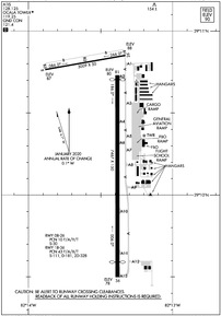
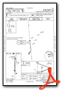
KOCF Airport Diagram
VFR Chart of KOCF
Sectional Charts at SkyVector.com
IFR Chart of KOCF
Enroute Charts at SkyVector.com
Location Information for KOCF
Coordinates: N29°10.31' / W82°13.45'Located 04 miles W of Ocala, Florida on 1532 acres of land. View all Airports in Florida.
Surveyed Elevation is 89 feet MSL.
Operations Data
|
|
Airport Communications
| ATIS: | 128.125 |
|---|---|
| AWOS-3PT: | 128.125 Tel. 352-237-8525 |
| OCALA TOWER: | 119.25 |
| OCALA GROUND: | 121.4 |
| JACKSONVILLE APPROACH: | 118.6 251.15 |
| JACKSONVILLE DEPARTURE: | 118.6 251.15 |
| CTAF: | 119.250 |
| AWOS-3T at X60 (17.0 NW): | 118.425 352-528-9949 |
| AWOS-3 at INF (22.5 S): | 119.975 352-560-6012 |
| AWOS-3 at CGC (25.9 SW): | 118.325 352-563-6600 |
Nearby Navigation Aids
|
| ||||||||||||||||||||||||||||||||||||||||||||||||


Runway 18/36
| Dimensions: | 7467 x 150 feet / 2276 x 46 meters | |
|---|---|---|
| Surface: | Asphalt / Grooved in Good Condition | |
| Weight Limits: | 43 /F/A/X/T, S-111, D-181, ST-328 | |
| Edge Lighting: | High Intensity | |
| Runway 18 | Runway 36 | |
| Coordinates: | N29°10.73' / W82°13.38' | N29°9.50' / W82°13.38' |
| Elevation: | 80.1 | 78.0 |
| Traffic Pattern: | Left | Left |
| Runway Heading: | 180° True | 360° True |
| Displaced Threshold: | 160 Feet | 561 Feet |
| Declared Distances: | TORA:7467 TODA:7467 ASDA:6717 LDA:6557 | TORA:7195 TODA:7195 ASDA:6907 LDA:6347 |
| Markings: | Precision Instrument in fair condition. | Precision Instrument in fair condition. |
| Glide Slope Indicator | P4L (3.00° Glide Path Angle) | P4L (3.00° Glide Path Angle) |
| Approach Lights: | MALSR 1,400 Foot Medium-intensity Approach Lighting System with runway alignment indicator lights. | |
| Obstacles: | 60 ft Trees 2600 ft from runway, 530 ft right of center | 46 ft Tree 2530 ft from runway, 410 ft right of center |
Runway 08/26
RWY 8/26 NOT AVBL FOR SKED ACR OPNS WITH MORE THAN 9 PAX SEATS OR UNSKED ACR AT LEAST 31 PAX SEATS. | ||
| Dimensions: | 3009 x 50 feet / 917 x 15 meters | |
|---|---|---|
| Surface: | Asphalt in Good Condition | |
| Weight Limits: | 10 /F/A/Y/T, S-30 | |
| Runway 08 | Runway 26 | |
| Coordinates: | N29°10.76' / W82°13.88' | N29°10.85' / W82°13.33' |
| Elevation: | 86.9 | 87.8 |
| Traffic Pattern: | Left | Left |
| Runway Heading: | 80° True | 260° True |
| Markings: | Basic in fair condition. | Basic in fair condition. |
| Obstacles: | 50 ft Trees 1205 ft from runway, 105 ft left of center | 25 ft Power Line 1045 ft from runway, 170 ft left of center |
Services Available
| Fuel: | 100LL (blue), Jet A-1+ |
|---|---|
| Transient Storage: | Hangars,Tiedowns |
| Airframe Repair: | MAJOR |
| Engine Repair: | MAJOR |
| Bottled Oxygen: | HIGH |
| Bulk Oxygen: | HIGH/LOW |
| Other Services: | AVIONICS,CHARTER SERVICE,PILOT INSTRUCTION,AIRCRAFT RENTAL,AIRCRAFT SALES |
Ownership Information
| Ownership: | Publicly owned | |
|---|---|---|
| Owner: | CITY OF OCALA | |
| 1770 SW 60TH AVENUE, SUITE 600 | ||
| OCALA, FL 34474 | ||
| 352-629-8377 | ||
| Manager: | MATTHEW GROW | |
| 1770 SW 60TH AVE, SUITE 600 | ||
| OCALA, FL 34474 | ||
| 352-629-8377 | ||
Operational Statistics
| Single Engine Aircraft Based on Field: | 141 | Statistics collected for 12 month period ending 2023-11-30 | |
|---|---|---|---|
| Multi-Engine Aircraft Based on Field: | 21 | Annual Commercial Operations: | 4 |
| Jet Aircraft Based on Field: | 21 | Annual Commuter Operations: | none |
| Helicopters Based on Field: | 9 | Annual Air Taxi Operations: | 2389 |
| Military Aircraft Based on Field: | none | Annual Military Operations: | 916 |
| Gliders Based on Field: | 1 | Annual GA Local Operations: | 28056 |
| Ultralights Based on Field: | none | Annual GA Itinerant Operations: | 55315 |
Other Remarks
- TWY A1 RSTRD TO ACFT WITH WINGSPAN 60 FT OR LESS.
- OBJECT 2.5 FT AGL LCTD 39 FT NORTH OF TWY A1 CNTRLN.
- RWY 36 RTHL NOT STD.
- RWY 18/36 REDL NOT STD.
- RWY 18 RENL NOT STD.
- RWY 18/36 SAFETY AREA NONSTD IRG SFC FM ONGOING WILDLIFE BURROW MITIGATATION.
- RWY 08/26 SAFETY AREA NONSTD IREG SFC FM ONGOING WILDLIFE BURROW MITIGATATION.
- ACFT DEP RWY 18 MNTN RWY HDG TO 800 FT AGL OR TIL RCHG END OF RWY WHICHEVER OCRS LTR BFR MAKING LEFT TURNS.
- TWY A1, A8, A9 & A12 E OF TWY A; TWY A NORTH OF TWY A2; CLSD TO ACR.
- CUSTOM SVC UNAVBL.
- SFC CONDS NOT RPRTD 1700-0700L.
- FOR CD IF UNA TO CTC ON FSS FREQ, CTC JACKSONVILLE APCH AT 904-741-0284.
- FEE FOR ACR OPS ONLY.
- CALM WIND RWY.
- WHEN ATCT CLSD ACTVT MALSR RWY 36; PAPI RWY 18 & 36; HIRL RWY 18/36 - CTAF.
Weather Minimums


Instrument Approach Procedure (IAP) Charts
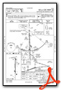
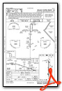
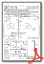
Nearby Airports with Instrument Procedures
| ID | Name | Heading / Distance | ||
|---|---|---|---|---|
 |
X35 | Marion County Airport | 230° | 10.4 |
|
X60 | Williston Municipal Airport | 310° | 16.9 |
|
KINF | Inverness Airport | 192° | 22.6 |
|
KCGC | Crystal River-Capt Tom Davis Field Airport | 225° | 25.9 |
|
KLEE | Leesburg International Airport | 133° | 30.2 |
|
KGNV | Gainesville Regional Airport | 355° | 31.1 |
|
X23 | Umatilla Municipal Airport | 116° | 33.5 |
|
28J | Palatka Municipal - Lt Kay Larkin Field Airport | 043° | 40.4 |
|
42J | Keystone Heights Airport | 012° | 41.3 |
|
KBKV | Brooksville-Tampa Bay Regional Airport | 196° | 43.5 |
|
X04 | Orlando Apopka Airport | 129° | 43.8 |
|
KDED | Deland Municipal-Sidney H Taylor Field Airport | 097° | 49.8 |
Airport Images
Do you have a recent image of this airport? Upload it here!


