Login
Register


OGB
Orangeburg Municipal Airport
Official FAA Data Effective 2024-04-18 0901Z
Chart Supplement

VFR Chart of KOGB
Sectional Charts at SkyVector.com
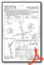
IFR Chart of KOGB
Enroute Charts at SkyVector.com
Location Information for KOGB
Coordinates: N33°27.42' / W80°51.56'Located 02 miles S of Orangeburg, South Carolina on 982 acres of land. View all Airports in South Carolina.
Surveyed Elevation is 195 feet MSL.
Operations Data
|
|
Airport Communications
| ASOS: | 118.525 Tel. 803-536-3901 |
|---|---|
| COLUMBIA APPROACH: | 124.15 338.2 |
| COLUMBIA DEPARTURE: | 124.15 338.2 |
| CTAF: | 122.700 |
| UNICOM: | 122.700 |
| ATIS at MMT (28.0 N): | 327.05 |
| AWOS-3 at BNL (29.1 SW): | 119.775 803-259-4536 |
| ASOS at CUB (31.6 N): | 118.675 803-929-0665 |
- APCH/DEP SVC PRVDD BY CAE (COLUMBIA METROPOLITAN, COLUMBIA SC) 124.15/338.2.
Nearby Navigation Aids
|
| ||||||||||||||||||||||||||||||||||||||||||||||||||||||||||||


Runway 17/35
| Dimensions: | 5399 x 100 feet / 1646 x 30 meters | |
|---|---|---|
| Surface: | Asphalt in Good Condition | |
| Weight Limits: | S-30, D-72 | |
| Edge Lighting: | Medium Intensity | |
| Runway 17 | Runway 35 | |
| Coordinates: | N33°27.65' / W80°51.71' | N33°26.78' / W80°51.47' |
| Elevation: | 172.7 | 186.0 |
| Traffic Pattern: | Left | |
| Runway Heading: | 167° True | 347° True |
| Markings: | Non-Precision Instrument in good condition. | Non-Precision Instrument in good condition. |
| Glide Slope Indicator | P2L (3.00° Glide Path Angle) | P2L (3.00° Glide Path Angle) |
| Approach Lights: | ODALS Omnidirectional Approach Lighting System | ODALS Omnidirectional Approach Lighting System |
| REIL: | Yes | Yes |
| Obstacles: | 84 ft Tree 2457 ft from runway, 287 ft left of center | |
Runway 05/23
| Dimensions: | 4508 x 100 feet / 1374 x 30 meters | |
|---|---|---|
| Surface: | Asphalt in Good Condition | |
| Weight Limits: | S-30, D-50 | |
| Edge Lighting: | Medium Intensity | |
| Runway 05 | Runway 23 | |
| Coordinates: | N33°27.38' / W80°51.83' | N33°27.93' / W80°51.24' |
| Elevation: | 170.3 | 195.1 |
| Traffic Pattern: | Right | Left |
| Runway Heading: | 42° True | 222° True |
| Markings: | Non-Precision Instrument in good condition. | Non-Precision Instrument in good condition. |
| Glide Slope Indicator | V4L (3.00° Glide Path Angle) RWY 5 VASI OTS INDEFINITELY | |
| REIL: | Yes | |
Services Available
| Fuel: | 100LL (blue), Jet-A |
|---|---|
| Transient Storage: | Tiedowns |
| Airframe Repair: | MINOR |
| Engine Repair: | MINOR |
| Bottled Oxygen: | NONE |
| Bulk Oxygen: | NONE |
| Other Services: | AVIONICS,PILOT INSTRUCTION |
Ownership Information
| Ownership: | Publicly owned | |
|---|---|---|
| Owner: | CITY OF ORANGEBURG | |
| PO BOX 387 | ||
| ORANGEBURG, SC 29115 | ||
| (803) 533-6010 | ||
| Manager: | BETTY BAKER | |
| 1811 AIRPORT ROAD | ||
| ORANGEBURG, SC 29115 | ||
| 803-534-5545 | ||
Operational Statistics
| Single Engine Aircraft Based on Field: | 26 | Statistics collected for 12 month period ending 2021-06-10 | |
|---|---|---|---|
| Multi-Engine Aircraft Based on Field: | 9 | Annual Commercial Operations: | none |
| Jet Aircraft Based on Field: | 3 | Annual Commuter Operations: | none |
| Helicopters Based on Field: | none | Annual Air Taxi Operations: | 197 |
| Military Aircraft Based on Field: | none | Annual Military Operations: | 41 |
| Gliders Based on Field: | none | Annual GA Local Operations: | 2678 |
| Ultralights Based on Field: | none | Annual GA Itinerant Operations: | 3584 |
Other Remarks
- RY 05 HAS MKD PLINES 1000 FT FROM THLD.
- GCO AVBL ON FREQ 125.675 MONITORED BY COLUMBIA APCH CTL.
- FOR CD IF UNA VIA GCO CTC JACKSONVILLE ARTCC AT 904-845-1592.
- ACTVT ODALS RY 17/35, REIL RY 23 & RY 17/35; MIRL RY 05/23 & RY 17/35 - CTAF. PAPI RYS 17 AND 35 OPER CONT.
Weather Minimums

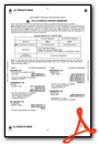
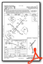
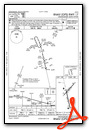
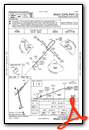
Instrument Approach Procedure (IAP) Charts
Nearby Airports with Instrument Procedures
| ID | Name | Heading / Distance | ||
|---|---|---|---|---|
 |
99N | Bamberg County Airport | 233° | 15.5 |
|
6J2 | St George Airport | 131° | 23.6 |
|
KMMT | Mc Entire Jngb Airport | 005° | 27.9 |
|
6J0 | Lexington County Airport | 316° | 28.0 |
|
KBNL | Barnwell Regional Airport | 245° | 29.1 |
|
KCUB | Jim Hamilton L B Owens Airport | 347° | 31.5 |
|
KCAE | Columbia Metro Airport | 335° | 31.7 |
|
KRBW | Lowcountry Regional Airport | 160° | 33.9 |
|
KAQX | Allendale County Airport | 216° | 34.5 |
|
KSSC | Shaw AFB Airport | 032° | 36.5 |
|
KDYB | Summerville Airport | 128° | 37.5 |
|
KSMS | Sumter Airport | 037° | 40.7 |
Airport Images
Do you have a recent image of this airport? Upload it here!


