Login
Register


OKB
Bob Maxwell Memorial Airfield Airport
Official FAA Data Effective 2024-04-18 0901Z
Chart Supplement

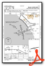
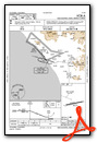
VFR Chart of KOKB
Sectional Charts at SkyVector.com
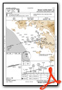
IFR Chart of KOKB
Enroute Charts at SkyVector.com
Location Information for KOKB
Coordinates: N33°13.08' / W117°21.09'Located 02 miles NE of Oceanside, California on 43 acres of land. View all Airports in California.
Surveyed Elevation is 28 feet MSL.
Operations Data
|
|
Airport Communications
| ASOS: | 127.8 Tel. 760-439-9683 |
|---|---|
| SOCAL APPROACH: | 127.3 323.0 |
| SOCAL DEPARTURE: | 127.3 323.0 |
| CTAF: | 122.725 |
| CLASS B: | 127.3 ;294-332 SAN BLW 7,000 FT 323.0 ;294-332 SAN BLW 7,000 FT |
| UNICOM: | 122.725 |
| ATIS at NFG (5.0 N): | 285.45 |
| ATIS at CRQ (6.5 SE): | 120.15 |
| ASOS at CRQ (6.5 SE): | 760-930-0864 |
- COMMUNICATIONS PRVDD BY SAN DIEGO RADIO ON FREQS 122.1R/115.3T (OCEANSIDE RCO).
Nearby Navigation Aids
|
| ||||||||||||||||||||||||||||||||||||||||||


Runway 07/25
| Dimensions: | 2712 x 75 feet / 827 x 23 meters | |
|---|---|---|
| Surface: | Asphalt in Good Condition | |
| Weight Limits: | S-12 | |
| Edge Lighting: | Medium Intensity | |
| Runway 07 | Runway 25 | |
| Coordinates: | N33°13.04' / W117°21.35' | N33°13.12' / W117°20.83' |
| Elevation: | 24.5 | 28.0 |
| Traffic Pattern: | Left | Right |
| Runway Heading: | 80° True | 260° True |
| Markings: | Non-Precision Instrument in good condition. | Non-Precision Instrument in good condition. |
| REIL: | Yes | |
| Obstacles: | 15 ft Road 420 ft from runway 8 FT FENCE, ROAD, AND 8+ FT TFC SIGNAL AT 345 FT. |
210 ft Hill 5300 ft from runway |
Services Available
| Fuel: | 100LL (blue), Jet-A |
|---|---|
| Transient Storage: | Tiedowns |
| Airframe Repair: | MINOR |
| Engine Repair: | MAJOR |
| Bottled Oxygen: | NONE |
| Bulk Oxygen: | NONE |
| Other Services: | AIR AMBULANCE SERVICES,PILOT INSTRUCTION,PARACHUTE JUMP ACTIVITY,AIRCRAFT RENTAL |
Ownership Information
| Ownership: | Publicly owned | |
|---|---|---|
| Owner: | CITY OF OCEANSIDE | |
| 300 NORTH COAST HIGHWAY | ||
| OCEANSIDE, CA 92054 | ||
| (760) 435-5012 | ||
| Manager: | ANDREW WIGNOT | |
| 480 AIRPORT ROAD, SUITE 715 | ||
| OCEANSIDE, CA 92058 | ||
| (760) 901-4260 | ||
Operational Statistics
| Single Engine Aircraft Based on Field: | 62 | Statistics collected for 12 month period ending 2023-12-31 | |
|---|---|---|---|
| Multi-Engine Aircraft Based on Field: | 2 | Annual Commercial Operations: | none |
| Jet Aircraft Based on Field: | none | Annual Commuter Operations: | none |
| Helicopters Based on Field: | 4 | Annual Air Taxi Operations: | none |
| Military Aircraft Based on Field: | none | Annual Military Operations: | none |
| Gliders Based on Field: | 1 | Annual GA Local Operations: | 12033 |
| Ultralights Based on Field: | none | Annual GA Itinerant Operations: | 14066 |
Other Remarks
- FENCE & ROAD WITHIN PRIMARY SFC NORTH SIDE.
- FOR CD CTC SOCAL APCH AT 800-448-3724.
- MTS W, NW, SW RWY 07 UP TO 280 FT MSL.
- UNLGTD MT APRX 160 FT MSL IN APCH ZONE AT 3500 FT FROM W END OF PVMT RWY 07.
- NOISE ABATEMENT IN EFCT: FLW RIVERBED ALL THE WAY TO COAST PRIOR TO MAKING ANY TURNS. DO NOT FLY OVER ANY HOUSES ALG RIVER BANKS. NO EARLY TURNOUTS PRIOR TO THE OCEAN. SKYDIVING OPS IN EFCT SR-SS DLY. PRCHT LNDG NORTH SIDE OF RWY BTW DOWNWIND AND RWY; NO EFCT ON ACFT TKOF/LNDG THAT FLW TFC PAT. USE CTN WHILE IN THE PAT.
- DO NOT CONFUSE ROAD SOUTH OF ARPT WITH THE RWY.
- BIRDS ON AND INVOF ARPT.
- 0LL FUEL AVBL 24 HRS 100LL SELF SVC, FULL SVC 0900-1630; JET A 0900-1700.
- MIRL RWY 07/25 PRESET LOW INTST; TO INCR INTST ACTVT - CTAF.
Weather Minimums
Instrument Approach Procedure (IAP) Charts
Nearby Airports with Instrument Procedures
| ID | Name | Heading / Distance | ||
|---|---|---|---|---|
 |
KNFG | Camp Pendleton MCAS (Munn Field) Airport | 357° | 5.0 |
|
KCRQ | Mc Clellan-Palomar Airport | 146° | 6.5 |
|
KNKX | Miramar MCAS (Joe Foss Field) Airport | 153° | 23.4 |
|
F70 | French Valley Airport | 027° | 24.1 |
|
KRNM | Ramona Airport | 115° | 24.5 |
|
KMYF | Montgomery-Gibbs Exec Airport | 156° | 26.4 |
|
KSAN | San Diego International Airport | 164° | 30.1 |
|
KSEE | Gillespie Field Airport | 140° | 30.3 |
|
KNZY | North Island NAS (Halsey Field) Airport | 167° | 31.9 |
|
KHMT | Hemet-Ryan Airport | 028° | 35.0 |
|
KSNA | John Wayne/Orange County Airport | 316° | 37.7 |
|
KRIV | March Arb Airport | 006° | 40.0 |
Airport Images
Do you have a recent image of this airport? Upload it here!


