Login
Register


OLF
L M Clayton Airport
Official FAA Data Effective 2024-04-18 0901Z
Chart Supplement

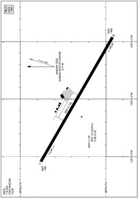
KOLF Airport Diagram
VFR Chart of KOLF
Sectional Charts at SkyVector.com
IFR Chart of KOLF
Enroute Charts at SkyVector.com
Location Information for KOLF
Coordinates: N48°5.67' / W105°34.50'Located 03 miles NE of Wolf Point, Montana on 290 acres of land. View all Airports in Montana.
Surveyed Elevation is 1988 feet MSL.
Operations Data
|
|
Airport Communications
| ASOS: | 118.325 Tel. 406-653-3865 |
|---|---|
| UNICOM: | 122.800 |
| CTAF: | 122.800 |
| AWOS-3PT at PO1 (16.7 E): | 135.325 406-448-2453 |
| AWOS-2 at 4U6 (40.5 S): | 119.025 406-485-3760 |
| ASOS at GGW (42.2 W): | 135.175 406-228-8294 |
- APCH/DEP CTL SVC PRVDD BY SALT LAKE ARTCC (ZLC) ON FREQS 126.85/305.2 (GLASGOW RCAG).
Nearby Navigation Aids
|
| ||||||||||||||||||||||||||||||

Runway 11/29
| Dimensions: | 5091 x 100 feet / 1552 x 30 meters | |
|---|---|---|
| Surface: | Asphalt / Grooved in Good Condition | |
| Weight Limits: | 14 /F/D/X/U, S-38, D-50 | |
| Edge Lighting: | Medium Intensity | |
| Runway 11 | Runway 29 | |
| Coordinates: | N48°5.88' / W105°35.04' | N48°5.46' / W105°33.96' |
| Elevation: | 1986.8 | 1985.3 |
| Traffic Pattern: | Left | Left |
| Runway Heading: | 120° True | 300° True |
| Markings: | Non-Precision Instrument in good condition. | Non-Precision Instrument in good condition. |
| Glide Slope Indicator | P2L (3.00° Glide Path Angle) | P2L (3.00° Glide Path Angle) |
| REIL: | Yes | Yes |
Services Available
| Fuel: | 100LL (blue) |
|---|---|
| Transient Storage: | Hangars,Tiedowns |
| Airframe Repair: | NONE |
| Engine Repair: | NONE |
| Bottled Oxygen: | NONE |
| Bulk Oxygen: | NONE |
| Other Services: | AIR FREIGHT SERVICES,CROP DUSTING SERVICES,AIR AMBULANCE SERVICES |
Ownership Information
| Ownership: | Publicly owned | |
|---|---|---|
| Owner: | CITY OF WOLF POINT-ROOSEVELT COUNTY | |
| 201 4TH AVE SOUTH | ||
| WOLF POINT, MT 59201 | ||
| 406-653-1852 | ||
| Manager: | ED BACH | ALTN MGR TOM ROMO WITH SAME CTC INFO AS ED BACH. |
| WOLF POINT AIRPORT, 201 4TH AVE SOUTH | ||
| WOLF POINT, MT 59201 | ||
| (406) 650-8305 | ||
Operational Statistics
| Single Engine Aircraft Based on Field: | 3 | Statistics collected for 12 month period ending 2019-06-04 | |
|---|---|---|---|
| Multi-Engine Aircraft Based on Field: | none | Annual Commercial Operations: | none |
| Jet Aircraft Based on Field: | none | Annual Commuter Operations: | none |
| Helicopters Based on Field: | none | Annual Air Taxi Operations: | 1568 |
| Military Aircraft Based on Field: | none | Annual Military Operations: | 4 |
| Gliders Based on Field: | none | Annual GA Local Operations: | 2100 |
| Ultralights Based on Field: | none | Annual GA Itinerant Operations: | 930 |
Other Remarks
- WILDLIFE HAZ; WATERFOWL IN VCNTY.
- FOR CD IF UNA TO CTC ON FSS FREQ, CTC SALT LAKE ARTCC AT 801-320-2568.
- FOR SVC AFT NML BUS HRS CALL AMGR 406-688-8308 OR 406-650-8305.
- 0LL 24 HR SELF SVC CREDIT CARD FUEL FAC. JET A FUEL NOT AVBL.
- ACTVT REIL RWY 11 & 29; PAPI RWY 11 & 29; MIRL RWY 11/29 - CTAF.
Weather Minimums
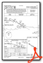
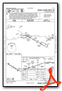
Instrument Approach Procedure (IAP) Charts
Nearby Airports with Instrument Procedures
| ID | Name | Heading / Distance | ||
|---|---|---|---|---|
 |
PO1 | Poplar Municipal Airport | 081° | 16.8 |
|
4U6 | Circle Town County Airport | 179° | 40.6 |
|
KGGW | Wokal Field/Glasgow-Valley County Airport | 280° | 42.4 |
|
9S2 | Scobey Airport | 007° | 43.2 |
|
KPWD | Sher-Wood Airport | 044° | 59.2 |
|
KSDY | Sidney-Richland Regional Airport | 112° | 60.5 |
|
KGDV | Dawson Community Airport | 151° | 65.3 |
|
KXWA | Williston Basin International Airport | 081° | 73.9 |
|
M75 | Malta Airport | 280° | 95.4 |
|
S25 | Watford City Municipal Airport | 100° | 95.5 |
|
20U | Beach Airport | 136° | 95.5 |
|
KMLS | Frank Wiley Field Airport | 187° | 100.9 |
Airport Images
Do you have a recent image of this airport? Upload it here!


