Login
Register


OQU
Quonset State Airport
Official FAA Data Effective 2024-04-18 0901Z
Chart Supplement

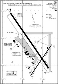
KOQU Airport Diagram
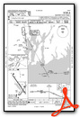
VFR Chart of KOQU
Sectional Charts at SkyVector.com
IFR Chart of KOQU
Enroute Charts at SkyVector.com
Location Information for KOQU
Coordinates: N41°35.83' / W71°24.73'Located 03 miles NE of North Kingstown, Rhode Island on 754 acres of land. View all Airports in Rhode Island.
Surveyed Elevation is 18 feet MSL.
MIL TFC PAT ROTARY WING 700 FT; FIXED WING 1000 FT AGL.
Operations Data
|
|
Airport Communications
| ATIS: | 118.6 |
|---|---|
| QUONSET TOWER: | 126.35 252.9 |
| QUONSET GROUND: | 134.5 226.675 |
| PROVIDENCE APPROACH: | 123.675 244.875 |
| PROVIDENCE DEPARTURE: | 123.675 244.875 |
| CLEARANCE DELIVERY: | 134.5 |
| EMERG: | 121.5 243.0 |
| CTAF: | 126.350 |
| COMD POST: | 335.95 ;QUAHOG |
| OPS: | 372.175 ;RHODY OPS |
| ARNG OPS: | 233.15 36.8 |
| WIPOR STAR: | 123.675 244.875 |
| UNICOM: | 122.950 |
| ASOS at UUU (7.0 SE): | 132.075 401-846-5910 |
| D-ATIS at PVD (7.5 N): | 124.2 |
| ASOS at PVD (7.6 N): | 124.2 401-734-2818 |
- APCH/DEP SVC PRVDD BY BOSTON ARTCC ON FREQS 124.85/307.9(WOODSTOCK RCAG) WHEN PROVIDENCE APCH CTL CLSD.
Nearby Navigation Aids
|
| ||||||||||||||||||||||||||||||||||||||||||||||||||||||||||||


Runway 16/34
| Dimensions: | 7504 x 150 feet / 2287 x 46 meters | |
|---|---|---|
| Surface: | Asphalt / Grooved in Fair Condition RWY 34 UNEVEN PAVEMENT APRXLY 1000-2000 FT FM AER 34 THR. RCMD TWY A-2 INTXN DEP FOR RWY 34, 5500 FT RMNG. CTC AMGR 401-295-5020. | |
| Weight Limits: | D-175 | |
| Edge Lighting: | High Intensity | |
| Runway 16 | Runway 34 | |
| Coordinates: | N41°36.46' / W71°25.30' | N41°35.45' / W71°24.36' |
| Elevation: | 18.3 | 9.9 |
| Traffic Pattern: | Left | Left |
| Runway Heading: | 145° True | 325° True |
| Displaced Threshold: | 403 Feet | |
| Declared Distances: | TORA:7100 TODA:7100 ASDA:7100 LDA:7100 | TORA:7500 TODA:7500 ASDA:7500 LDA:7100 |
| Markings: | Precision Instrument in fair condition. | Precision Instrument in good condition. |
| Glide Slope Indicator | P4L (3.00° Glide Path Angle) | P4L (3.00° Glide Path Angle) |
| Approach Lights: | MALSR 1,400 Foot Medium-intensity Approach Lighting System with runway alignment indicator lights. | |
| Obstacles: | 45 ft Trees 1400 ft from runway, 300 ft right of center | APCH RATIO 50:1 TO DTHR. |
Runway 05/23
| Dimensions: | 4000 x 75 feet / 1219 x 23 meters | |
|---|---|---|
| Surface: | Asphalt in Good Condition RWY 23 UNEVEN PAVEMENT APRXLY 100-400 FT FM AER 23 THR. CTC AMGR 401-295-5020. | |
| Weight Limits: | S-12 | |
| Edge Lighting: | Medium Intensity | |
| Runway 05 | Runway 23 | |
| Coordinates: | N41°35.32' / W71°24.79' | N41°35.86' / W71°24.29' |
| Elevation: | 10.8 | 9.3 |
| Traffic Pattern: | Left | Left |
| Runway Heading: | 34° True | 214° True |
| Markings: | Basic in fair condition. | Basic in fair condition. |
| Glide Slope Indicator | P4L (3.00° Glide Path Angle) | P4R (3.00° Glide Path Angle) |
| REIL: | Yes | Yes |
| Obstacles: | 12 ft Pole 360 ft from runway, 100 ft right of center | |
Services Available
| Fuel: | 100LL (blue), Jet-A |
|---|---|
| Transient Storage: | Tiedowns |
| Airframe Repair: | NOT AVAILABLE |
| Engine Repair: | NOT AVAILABLE |
| Bottled Oxygen: | NONE |
| Bulk Oxygen: | NONE |
| Other Services: | PILOT INSTRUCTION,AIRCRAFT RENTAL |
Ownership Information
| Ownership: | Publicly owned | |
|---|---|---|
| Owner: | RHODE ISLAND AIRPORT CORP | |
| T.F. GREEN STATE AIRPORT, 2000 POST RD | ||
| WARWICK, RI 02806 | ||
| 401-691-2000 | ||
| Manager: | IFTIKHAR AHMAD | |
| RHODE ISLAND AIRPORT CORP, 2000 POST RD | ||
| WARWICK, RI 02886 | ||
| 401-691-2000 | ||
Operational Statistics
| Single Engine Aircraft Based on Field: | 8 | Statistics collected for 12 month period ending 2023-07-31 | |
|---|---|---|---|
| Multi-Engine Aircraft Based on Field: | none | Annual Commercial Operations: | none |
| Jet Aircraft Based on Field: | 1 | Annual Commuter Operations: | none |
| Helicopters Based on Field: | none | Annual Air Taxi Operations: | 1104 |
| Military Aircraft Based on Field: | 12 | Annual Military Operations: | 7820 |
| Gliders Based on Field: | none | Annual GA Local Operations: | 5980 |
| Ultralights Based on Field: | none | Annual GA Itinerant Operations: | 2944 |
Other Remarks
- THIS AIRPORT HAS BEEN SURVEYED BY THE NATIONAL GEODETIC SURVEY.
- DEER, BIRDS & WATERFOWL ON & INVOF ARPT.
- MILITARY: ARNG: OPR 1200-2230Z++ TUE-FRI, EXC HOL. PPR FOR TSNT MIL ACFT LDG, PRKG ARNG RAMP & FUEL CTC DSN 247-4539, C401-275-4539. LTD PRKG, FUEL & MAINT AVBL, PRKG PAD 3 CLSD UFN. CALL HOPE OPS 233.15 (PRI), 36.80 (ALTN). PPR TO USE LCL TRG AREA.
- MILITARY: ANG: PPR FOR SVCG & USE OF ANG PRKG RAMP ONLY. AMOPS OPS 1200-2230Z++ TUES-FRI, EXCP HOL, DSN 476-3404/3405. TSNT ACFT INBD TO ANG PRKG RAMP CTC QUAHOG, COMD POST, 15 MIN PRIOR TO LDG.
- MILITARY: ANG: BASH PROGRAM IN EFF. 1 APR-31 MAY AND 1 AUG-31 OCT ARE DSGND PHASE II PERIODS FOR MIGRATORY BIRD ACT. INCRD HAZ FM CANADIAN GEESE FLYING EAST TO WEST OVER RWY. INBD ACFT CTC QUAHOG/RHODY OPS FOR LATEST BIRD WATCH CONDS.
- MILITARY: ANG: TMPRY STORAGE OF CLASSIFIED MTRLS UP TO SECRET AT COMD POST. ACFT REQ CUST/AG CTC AMOPS 7 DAYS PRIOR TO ARR.
- FUEL: A++ AVBL.
- FOR CD WHEN APCH CLSD CTC BOSTON ARTCC AT 603-879-6859.
- NMRS CRANES ON & INVOF ARPT.
- CIVIL ACFT USE CTN, HEIGHTENED SCTY MEASURES IN EFCT ON ANG AND ARMY RAMPS UFN.
- TWY R & TWY E CLSD INDEFLY.
- RWY CONDS MAY NOT BE MNT OR RPRTD WHEN ARPT IS UNATNDD. CTC RI ARPT CORPORATION OPS AT 401-691-2265.
- LGTD CRANES 125 FT HIGH AT PIER 1000 FT SE OF RWY 05.
- FUEL: J8(MIL) A+ (FBO OPR 1100-0200Z++. PPR MANDATORY DUR NON-DUTY HR. CTC C401-295-5020) (NC-100LL, A).
- MILITARY: RSTD: 180 DEG TURNS FOR ACFT OVER 12500 LB GWT PROH ON RWY 16/34.
- LDG FEE COML & NON RHODE ISLAND REGISTERED ACFT/OVNGT PRKG FEE.
- 8000 FT AVBL FOR MIL ACFT ONLY.
- ACTVT MALSR RWY 16; REIL RWY 05 & 23; PAPI RWY 05 & 23; MIRL RWY 05/23; HIRL RWY 16/34; TWY LGTS - CTAF.
- MIL TFC PAT ROTARY WING 700 FT; FIXED WING 1000 FT AGL.
Weather Minimums
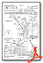
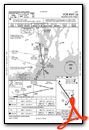
Standard Terminal Arrival (STAR) Charts
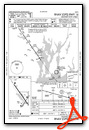
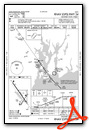
Instrument Approach Procedure (IAP) Charts
Nearby Airports with Instrument Procedures
| ID | Name | Heading / Distance | ||
|---|---|---|---|---|
 |
KUUU | Newport State Airport | 123° | 7.0 |
|
KPVD | Rhode Island Tf Green International Airport | 354° | 7.5 |
|
KSFZ | North Central State Airport | 349° | 19.7 |
|
KEWB | New Bedford Regional Airport | 076° | 21.0 |
|
KWST | Westerly State Airport | 230° | 23.1 |
|
KTAN | Taunton Municipal - King Field Airport | 046° | 24.3 |
|
1B9 | Mansfield Municipal Airport | 021° | 26.0 |
|
KBID | Block Island State Airport | 196° | 26.8 |
|
1B6 | Hopedale Industrial Park Airport | 351° | 30.9 |
|
KGON | Groton-New London Airport | 240° | 32.7 |
|
0B8 | Elizabeth Field Airport | 233° | 34.8 |
|
KIJD | Windham Airport | 284° | 35.6 |
Fuel Providers

Airport Images

By: jrns

By: thetwelfthfret


